METAR & TAF C44
C44 does not publish a METAR.
Showing the nearest reporting station: KIJD (WINDHAM) · 13.9 NM away. Conditions at C44 may differ.
METAR · KIJD
Observed 00:52Z
KIJD 270052Z AUTO 00000KT 10SM CLR 19/15 A2985 RMK AO2 SLP108 T01940150
- Wind
- 000° @ 0 kt
- Visibility
- 10 SM
- Temp / Dew
- 19°C / 15°C
- Altimeter
- 29.85 inHg
- Clouds
- CLR
- Density alt
- 1,522 ft
- Ceiling
- Unlimited
- Rules
- VFR
Airport info & contacts
Manager on record, flight service, ARTCC, attendance schedule and pattern altitude — published by the FAA and refreshed every 28 days.
Location
- From city
- 6 NM NW
- VFR sectional
- NEW YORK
- ARTCC
- ZBW · BOSTON
- NOTAM facility
- BDR (NOTAM-D)
Airport manager
- Name
- ROLAND J. TOUTANT
- Phone
- 860-974-2099
- Address
- 80 BUNGAY HILL ROAD, WEST WOODSTOCK CT 06281
Flight service · Hours
- FSS BDR
- BRIDGEPORT1-800-WX-BRIEF
- Attendance
- IREG
Frequencies
Tap any row to copy the frequency to your clipboard.
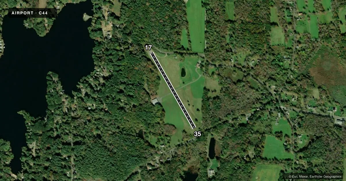
Runways & pattern
Full pagePattern entry · RWY 17
LEFT TRAFFICRunway end performance
| End | TORA | TODA | ASDA | LDA | VGSI | Approach lights | Obstruction |
|---|---|---|---|---|---|---|---|
| 17 | — | — | — | — | — | — | 70', trees, 201' from thr, 120' R of cntrln, slope 1 |
| 35 | — | — | — | — | — | — | 42', trees, 263' from thr, 22' R of cntrln, slope 1 |
Declared distances in feet. TORA = takeoff run available, TODA = takeoff distance, ASDA = accelerate-stop, LDA = landing distance.
Airport sketch
Runways drawn to scale from FAA survey coordinates, rendered over satellite imagery. Not for navigation.
Approaches & charts
Services on the field
Fuel grades, oxygen, maintenance, ramp storage and lighting — as declared to the FAA by the airport operator.
Fuel & services
- Fuel
- Not available
- Airframe repair
- Not available
- Power plant repair
- Not available
Ramp & ground
- Transient storage
- Tie-down
- Landing fee
- No fee published
- Wind indicator
- Yes
- Segmented circle
- No
Fuel & FBOs
Cheapest 100LL and Jet A on the field and nearby. Always confirm with the FBO before taxi.
Airport notes
Surface conditions, obstructions, local procedures, lighting outages and other notes published with each FAA cycle.
General notes
- ACFT BACK TAXI ON RWY.
- FOR CD CTC BRADLEY APCH AT 860-386-3597
- 40 FT DROP OFF AT EACH RWY END.
- ARPT CLSD SS-SR, NO LIGHTS.
Runway surface & condition
- 17/35NOT PLOWED; NO SKI OPNS.
Approach & departure obstructions
- 1770 FT TREES, 0-199 FT DSTC, 113 R; 10 FT PLINE, 0-199 FT DSTC, 113 L.
- 3525 FT TREE, 100 FT DSTC, 94 FT L.
Other notes
- VFR USE ONLY.
VFR map & nearby airports
VFR sectional. Tap any ICAO chip to open that airport.
Key facts · C44
Answer card- ICAO
- C44
- Name
- TOUTANT
- Location
- PUTNAM, CONNECTICUT
- Elevation
- 770 ft MSL
- Traffic pattern altitude
- 1,770 ft MSL (1,000 AGL)
- Control tower
- Non-towered (use CTAF)
- Total runways
- 1
- Longest runway
- 17/35 · 1,756 ft
- Published ILS approaches
- 0
- Published frequencies
- 1
- Magnetic variation
- 15°
- Current flight rules
- VFR
- Current wind
- 000° at 0 kt
- Favored runway now
- –
Toutant Airport sits in Putnam, Connecticut. Field elevation is 770 ft MSL. It has one runway, 17/35, which is 1,756 ft long and asphalt. The airport is not towered. CTAF is 122.9. No ILS approaches are published here. Pattern altitude is not published, so use the standard 1,000 ft AGL for light piston operations unless the current Chart Supplement says otherwise.
This is a VFR-only field. The published remarks also say the airport is closed from sunset to sunrise with no lights. That matters for any late arrival or departure planning. There are trees and a power line close to the approach end of runway 17. There is also a tree near runway 35. The runway has a 40 ft drop-off at each end. The field is not plowed, so no ski operations are published.
No on-field FBOs are listed. If you need fuel or ramp details, contact the airport operator or the FBO directly by phone before you go. For clearance delivery, the published contact is Bradley Approach at 860-386-3597. Expect back taxi on the runway. If you are planning a first visit, review the current Chart Supplement before departure so you have the latest notes on runway condition, obstructions and any operational limits.