METAR & TAF 7B6
7B6 does not publish a METAR.
Showing the nearest reporting station: KBDL (BRADLEY INTL) · 4.9 NM away. Conditions at 7B6 may differ.
METAR · KBDL
Observed 00:51Z
KBDL 250051Z 31004KT 10SM FEW200 SCT250 22/12 A2996 RMK AO2 SLP144 T02170117 $
- Wind
- 310° @ 4 kt
- Visibility
- 10 SM
- Temp / Dew
- 22°C / 12°C
- Altimeter
- 29.96 inHg
- Clouds
- SCT
- Density alt
- 939 ft
- Ceiling
- Unlimited
- Rules
- VFR
Airport info & contacts
Manager on record, flight service, ARTCC, attendance schedule and pattern altitude — published by the FAA and refreshed every 28 days.
Location
- From city
- 2 NM E
- VFR sectional
- NEW YORK
- ARTCC
- ZBW · BOSTON
- NOTAM facility
- BDR (NOTAM-D)
Airport manager
- Name
- WILLIAM KULLE
- Phone
- (413) 537-5121
- Address
- 54 WELLS RD, BROADBROOK CT 06016
Flight service · Hours
- FSS BDR
- BRIDGEPORT1-800-WX-BRIEF
- Attendance
- DALGT
Frequencies
Tap any row to copy the frequency to your clipboard.
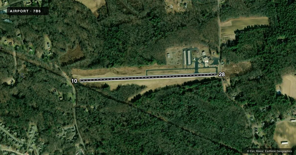
Runways & pattern
Full pagePattern entry · RWY 28
LEFT TRAFFICRunway end performance
| End | TORA | TODA | ASDA | LDA | VGSI | Approach lights | Obstruction |
|---|---|---|---|---|---|---|---|
| 10 | — | — | — | — | — | — | 30', pline, 250' from thr, 150' R of cntrln, slope 1 |
| 28 | — | — | — | — | — | — | 67', trees, 266' from thr, 152' R of cntrln, slope 1 |
Declared distances in feet. TORA = takeoff run available, TODA = takeoff distance, ASDA = accelerate-stop, LDA = landing distance.
Airport sketch
Runways drawn to scale from FAA survey coordinates, rendered over satellite imagery. Not for navigation.
Approaches & charts
Services on the field
Fuel grades, oxygen, maintenance, ramp storage and lighting — as declared to the FAA by the airport operator.
Fuel & services
- Fuel
- 100LL
- Oxygen (bottled)
- Not available
- Oxygen (bulk)
- Not available
- Airframe repair
- Major
- Power plant repair
- Major
- Other services
- INSTR,RNTL,SALES
Ramp & ground
- Transient storage
- Tie-down
- Hangar
- Landing fee
- No fee published
- Customs
- Not available
- Lighting schedule
- SEE RMK
- Wind indicator
- Yes
- Segmented circle
- No
Fuel & FBOs
Cheapest 100LL and Jet A on the field and nearby. Always confirm with the FBO before taxi.
Airport notes
Surface conditions, obstructions, local procedures, lighting outages and other notes published with each FAA cycle.
General notes
- ARPT LGTS OTS INDEFLY.
- NO NGT TGL.
- BRING TIEDOWN ROPES
- FOR CD CTC BRADLEY APCH AT 860-386-3597.
Lighting notes
- ACTIVATE LIRL RWY 10/28 - 122.8.
Fuel notes
- 100LLCALL FIRST FOR AVAILABILITY OF FUEL.
Runway surface & condition
- 10/28RY 10/28 FIRST 175 FT EAST END UNLGTD.
Approach & departure obstructions
- 28+4 FT FENCE 55 FT FM RY END; +15 FT ROADWAY 65 FT FM RY END.
- 10RY 10 APCH RATIO 11:1 TO 100 FT TREES 1119 FT FM DSPLCD THLD 100 FT R OF CNTRLN.
- 28RY 28 APCH RATIO 6:1 TO 63 FT TREE 577 FT FM DSPLCD THLD 170 FT L OF CNTRLN.
Other notes
- EXISTED PRIOR TO 1959.
VFR map & nearby airports
VFR sectional. Tap any ICAO chip to open that airport.
Key facts · 7B6
Answer card- ICAO
- 7B6
- Name
- SKYLARK AIRPARK
- Location
- WAREHOUSE POINT, CONNECTICUT
- Elevation
- 120 ft MSL
- Traffic pattern altitude
- 1,120 ft MSL (1,000 AGL)
- Control tower
- Non-towered (use CTAF)
- Total runways
- 1
- Longest runway
- 10/28 · 3,242 ft
- Published ILS approaches
- 0
- Published frequencies
- 2
- Magnetic variation
- 14°
- Current flight rules
- VFR
- Current wind
- 310° at 4 kt
- Favored runway now
- RWY 28
Skylark Airpark (7B6) sits in Warehouse Point, Connecticut. Field elevation is 120 ft MSL. The airport has one runway. Runway 10/28 is 3,242 ft of asphalt, which makes the runway length the main planning item here. There is no control tower. CTAF and UNICOM are both 122.8.
No ILS approaches are published for 7B6. Pattern altitude is not published, so use the standard 1,000 ft AGL for light piston aircraft unless the current Chart Supplement says otherwise. The published remarks matter here. Runway 10/28 is unlighted for the first 175 ft at the east end. Airport lights are out of service indefinitely. Night touch-and-go operations are not allowed. For clearance delivery, Bradley Approach is listed at 860-386-3597. Low intensity runway lights for 10/28 are activated on 122.8.
First-time arrivals should pay close attention to the runway 10 and 28 obstacle notes. There are trees near both approaches, plus a fence and roadway close to the runway end on 28. No on-field FBOs are listed, so call the airport operator directly or the field on CTAF for current fuel and service availability. 100LL availability is by call first. Bring tiedown ropes if you plan to park for any length of time.