METAR & TAF 4B9
4B9 does not publish a METAR.
Showing the nearest reporting station: KBDL (BRADLEY INTL) · 4.4 NM away. Conditions at 4B9 may differ.
METAR · KBDL
Observed 12:51Z
KBDL 271251Z VRB03KT 10SM FEW100 FEW250 21/14 A2985 RMK AO2 SLP108 T02060139 $
- Wind
- VAR @ 3 kt
- Visibility
- 10 SM
- Temp / Dew
- 21°C / 14°C
- Altimeter
- 29.85 inHg
- Clouds
- FEW
- Density alt
- 1,049 ft
- Ceiling
- Unlimited
- Rules
- VFR
Airport info & contacts
Manager on record, flight service, ARTCC, attendance schedule and pattern altitude — published by the FAA and refreshed every 28 days.
Location
- From city
- 3 NM NE
- VFR sectional
- NEW YORK
- ARTCC
- ZBW · BOSTON
- NOTAM facility
- BDR (NOTAM-D)
Airport manager
- Name
- BRAD GRISWOLD
- Phone
- 860-459-1575
- Address
- 119 PARK RD, PLEASANT VALLEY CT 06063
Flight service · Hours
- FSS BDR
- BRIDGEPORT1-800-WX-BRIEF
- Attendance
- 0830-1700
Frequencies
Tap any row to copy the frequency to your clipboard.
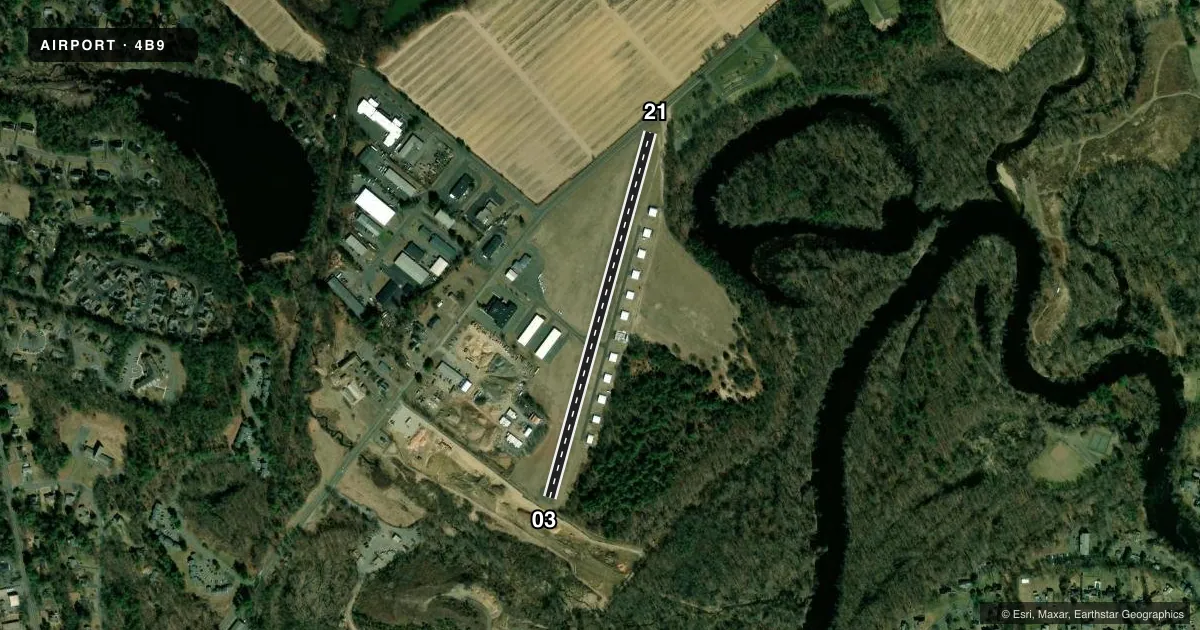
Runways & pattern
Full pagePattern entry · RWY 03
LEFT TRAFFICRunway end performance
| End | TORA | TODA | ASDA | LDA | VGSI | Approach lights | Obstruction |
|---|---|---|---|---|---|---|---|
| 03 | — | — | — | — | — | — | 75', trees, 780' from thr, 75' R of cntrln, slope 7 |
| 21 | — | — | — | — | — | — | 60', trees, 201' from thr, 77' R of cntrln, slope 1 |
Declared distances in feet. TORA = takeoff run available, TODA = takeoff distance, ASDA = accelerate-stop, LDA = landing distance.
Airport sketch
Runways drawn to scale from FAA survey coordinates, rendered over satellite imagery. Not for navigation.
Approaches & charts
Services on the field
Fuel grades, oxygen, maintenance, ramp storage and lighting — as declared to the FAA by the airport operator.
Fuel & services
- Fuel
- 100LL
- Oxygen (bottled)
- Not available
- Oxygen (bulk)
- Not available
- Airframe repair
- Major
- Power plant repair
- Major
- Other services
- INSTR
Ramp & ground
- Transient storage
- Tie-down
- Landing fee
- No fee published
- Customs
- Not available
- Lighting schedule
- SEE RMK
- Wind indicator
- Lighted
- Segmented circle
- Yes
Fuel & FBOs
Cheapest 100LL and Jet A on the field and nearby. Always confirm with the FBO before taxi.
Airport notes
Surface conditions, obstructions, local procedures, lighting outages and other notes published with each FAA cycle.
General notes
- DEER & BIRDS ON & INVOF ARPT - BIRDS PARTICULARLY IN APCH TO RWY 03.
- RWY 03 HAS AN UP-HILL GRADE.
- FOR CD CTC BRADLEY APCH AT 860-386-3597.
Lighting notes
- DUSK-DAWN. ACTVT MIRL RWY 03/21 - CTAF.
Runway surface & condition
- 03/21RWY 3/21 SAFETY BARRIER 15 FT NE THR BARRICADE NOT LGTD.
- 03/21NSTD THLD LIGHTS GREEN/GREEN.
Approach & departure obstructions
- 0370 FT TREES, 25-50 FT DSTC, 123 FT R.
- 2140 FT TREES, 0 FT DSTC, 123 FT L.
- 21APCH RATIO 21:1 TO DTHR.
Other notes
- EXISTED PRIOR TO 1959.
VFR map & nearby airports
VFR sectional. Tap any ICAO chip to open that airport.
Key facts · 4B9
Answer card- ICAO
- 4B9
- Name
- SIMSBURY
- Location
- SIMSBURY, CONNECTICUT
- Elevation
- 195 ft MSL
- Traffic pattern altitude
- 1,195 ft MSL (1,000 AGL)
- Control tower
- Non-towered (use CTAF)
- Total runways
- 1
- Longest runway
- 03/21 · 2,205 ft
- Published ILS approaches
- 0
- Published frequencies
- 2
- Magnetic variation
- 14°
- Current flight rules
- VFR
- Current wind
- 000° at 3 kt
- Favored runway now
- RWY 03
Simsbury Airport sits in Simsbury, Connecticut. Field elevation is 195 ft MSL. It has one runway, 03/21, at 2,205 ft asphalt. There is no control tower. CTAF and UNICOM are both 122.7. No ILS approaches are published here. Pattern altitude is not published, so use the standard 1,000 ft AGL for light piston traffic unless the current Chart Supplement says otherwise.
Simsbury Airport has one on-field FBO. Simsbury Airport carries AVGAS 100LL. Call (860) 459-1575 before you go if you need current field details. Published remarks matter here. Runway 03 has an uphill grade. Runway 03/21 also has medium intensity lights that come on from dusk to dawn through the CTAF. The threshold lighting is nonstandard with green over green. There are trees close to both runway ends. Deer and birds are also reported on and near the airport. Birds are a bigger concern on the approach to runway 03.
This is a non-towered field, so plan your self-announce calls carefully. The runway is short enough that performance planning matters. The published remarks also note a displaced threshold issue on runway 21, so brief your landing distance and go-around plan before arrival. If you need clearance delivery, contact Bradley Approach at 860-386-3597.