METAR & TAF 4B8
Current METAR
Observed 13:35Z
K4B8 271335Z AUTO VRB03KT 9SM CLR 22/17 A2984 RMK AO2 T02230173 $
- Wind
- VAR @ 3 kt
- Visibility
- 9 SM
- Temp / Dew
- 22°C / 17°C
- Altimeter
- 29.84 inHg
- Clouds
- CLR
- Density alt
- 1,189 ft
- Ceiling
- Unlimited
- Rules
- VFR
Airport info & contacts
Manager on record, flight service, ARTCC, attendance schedule and pattern altitude — published by the FAA and refreshed every 28 days.
Location
- From city
- 2 NM N
- VFR sectional
- NEW YORK
- Pattern altitude
- 800 ft AGL · 1,002 ft MSL
- ARTCC
- ZBW · BOSTON
- NOTAM facility
- BDR (NOTAM-D)
Airport manager
- Name
- NICHOLAS SCATA
- Phone
- 860-747-5519
- Address
- 62 JOHNSON AVE, PLAINVILLE CT 06062
Flight service · Hours
- FSS BDR
- BRIDGEPORT1-800-WX-BRIEF
- Attendance
- MON-FRI · 0800-1900
- SAT-SUN · 0800-1800
Frequencies
Tap any row to copy the frequency to your clipboard.
Runways & pattern
Full pagePattern entry · RWY 02
LEFT TRAFFICRunway end performance
| End | TORA | TODA | ASDA | LDA | VGSI | Approach lights | Obstruction |
|---|---|---|---|---|---|---|---|
| 02 | — | — | — | — | PAPI 2-box left(3°) | — | 17', trees, 250' from thr, 67' R of cntrln, slope 2 |
| 20 | — | — | — | — | PAPI 2-box right(3.5°) | — | 50', trees, 240' from thr, 105' R of cntrln, slope 1 |
Declared distances in feet. TORA = takeoff run available, TODA = takeoff distance, ASDA = accelerate-stop, LDA = landing distance.
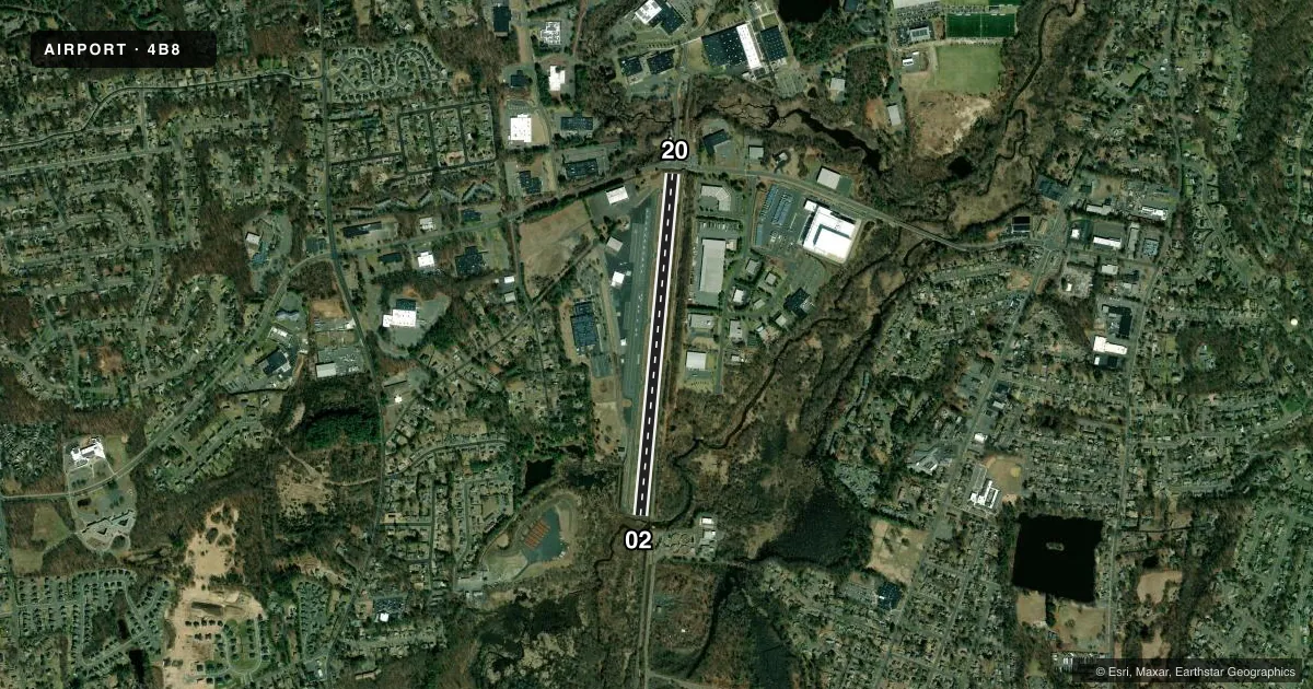
Airport sketch
Runways drawn to scale from FAA survey coordinates, rendered over satellite imagery. Not for navigation.
Approaches & charts
Services on the field
Fuel grades, oxygen, maintenance, ramp storage and lighting — as declared to the FAA by the airport operator.
Fuel & services
- Fuel
- 100LLA
- Oxygen (bottled)
- HIGH/LOW
- Oxygen (bulk)
- Not available
- Airframe repair
- Major
- Power plant repair
- Major
- Other services
- CHTR,INSTR,RNTL
Ramp & ground
- Transient storage
- Tie-down
- Hangar
- Landing fee
- No fee published
- Customs
- Not available
- Lighting schedule
- SEE RMK
- Beacon schedule
- SS-SR
- Beacon
- White / Green (civil land)(WG)
- Wind indicator
- Lighted
- Segmented circle
- No
Fuel & FBOs
Cheapest 100LL and Jet A on the field and nearby. Always confirm with the FBO before taxi.
Airport notes
Surface conditions, obstructions, local procedures, lighting outages and other notes published with each FAA cycle.
General notes
- NOISE ABATEMENT PROCS IN EFCT. CTC 1-800-573-5519 OR 860-747-5519 FOR DTLS.
- FOR CD CTC BRADLEY APCH AT 860-386-3597.
- CTN DEER & BIRDS ON & INVOF ARPT.
Lighting notes
- ACTVT REIL RWY 02 & 20; MIRL RWY 02/20 - CTAF. PAPI RWY 02 & 20 OPR CONSLY.
Approach & departure obstructions
- 0210 FT BRUSH, 15 FT DSTC, 90 FT L.
Other notes
- EXISTED PRIOR TO 1959.
- LDG FEE FOR COML AND CORPORATE ACFT ONLY.
- TPA: 800 FT FOR ACFT LESS THAN 12500 LBS, 1300 FT FOR ACFT 12500 LBS & ABV.
VFR map & nearby airports
VFR sectional. Tap any ICAO chip to open that airport.
Key facts · 4B8
Answer card- ICAO
- 4B8
- Name
- ROBERTSON FLD
- Location
- PLAINVILLE, CONNECTICUT
- Elevation
- 201.8 ft MSL
- Traffic pattern altitude
- 1,001.8 ft MSL (800 AGL)
- Control tower
- Non-towered (use CTAF)
- Total runways
- 1
- Longest runway
- 02/20 · 3,666 ft
- Published ILS approaches
- 0
- Published frequencies
- 5
- Magnetic variation
- 14°
- Current flight rules
- VFR
- Current wind
- 000° at 3 kt
- Favored runway now
- RWY 02
Robertson Fld is in Plainville, Connecticut. The field elevation is 201.8 ft MSL. It has one runway, 02/20, which is 3,666 ft long and paved with asphalt. There is no control tower. The pattern altitude is 800 ft AGL, which is 1,001.8 ft MSL for aircraft under 12,500 lb. Aircraft 12,500 lb and above use 1,300 ft AGL.
No ILS approaches are published here. The airport uses CTAF 122.8 for local traffic. Bradley Approach handles clearance delivery and approach or departure services. Noise abatement procedures are in effect, so check the current Chart Supplement before you go. There is also a brush obstruction near the left side of runway 02. Deer and birds are a known issue on and near the airport.
Interstate Aviation is on the field. It carries 100LL and Jet A. Runway lighting is pilot-controlled on CTAF. REILs are installed on runways 02 and 20. PAPI is available on both ends and operates continuously. For a first-time arrival, pay close attention to the pattern altitude, the noise procedures and the wildlife risk. The runway length is workable for many GA aircraft. The published remarks also note that the airport existed before 1959.