METAR & TAF KOXC
Current METAR
Observed 11:56Z
KOXC 271156Z AUTO 00000KT 10SM BKN100 19/17 A2987 RMK AO2 SLP122 60001 70002 T01890172 10189 20150 53009 $
- Wind
- 000° @ 0 kt
- Visibility
- 10 SM
- Temp / Dew
- 19°C / 17°C
- Altimeter
- 29.87 inHg
- Clouds
- BKN
- Density alt
- 1,447 ft
- Ceiling
- 10,000 ft AGL
- Rules
- VFR
Airport info & contacts
Manager on record, flight service, ARTCC, attendance schedule and pattern altitude — published by the FAA and refreshed every 28 days.
Location
- From city
- 3 NM N
- VFR sectional
- NEW YORK
- ARTCC
- ZNY · NEW YORK
- NOTAM facility
- OXC (NOTAM-D)
Airport manager
- Name
- WILLIE MCBRIDE
- Phone
- 203-264-8010
- Address
- 300 CHRISTIAN ST, OXFORD CT 06478
Flight service · Hours
- FSS BDR
- BRIDGEPORT1-800-WX-BRIEF
- Attendance
- ALL
Frequencies
Tap any row to copy the frequency to your clipboard.
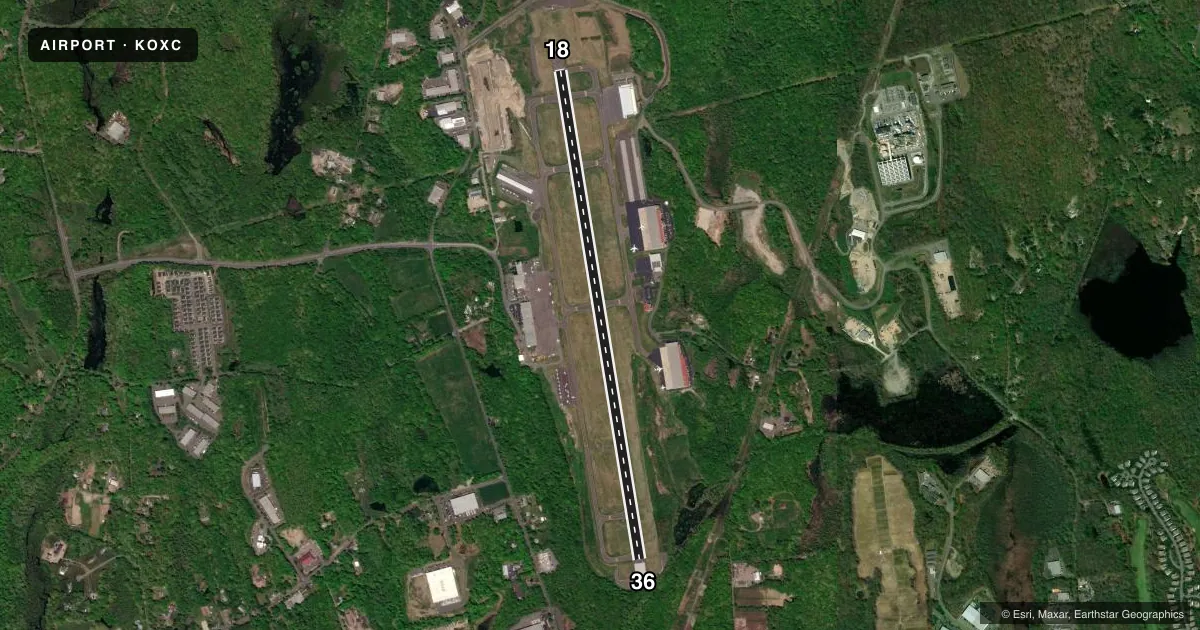
Runways & pattern
Full pagePattern entry · RWY 18
RIGHT TRAFFICRunway end performance
| End | TORA | TODA | ASDA | LDA | VGSI | Approach lights | Obstruction |
|---|---|---|---|---|---|---|---|
| 18 | 5,801' | 5,801' | 5,801' | 5,801' | PAPI 4-box left(3°) | — | — |
| 36 | 5,801' | 5,801' | 5,801' | 5,301' | PAPI 4-box left(3°) | — | 50', pline, 1000' from thr, 600' R of cntrln, slope 16 |
Declared distances in feet. TORA = takeoff run available, TODA = takeoff distance, ASDA = accelerate-stop, LDA = landing distance.
Airport sketch
Runways drawn to scale from FAA survey coordinates, rendered over satellite imagery. Not for navigation.
Approaches & charts
ILS · 1
Services on the field
Fuel grades, oxygen, maintenance, ramp storage and lighting — as declared to the FAA by the airport operator.
Fuel & services
- Fuel
- 100LLA
- Oxygen (bottled)
- Not available
- Oxygen (bulk)
- Not available
- Airframe repair
- Major
- Power plant repair
- Major
- Other services
- AVNCS,CHTR,INSTR,RNTL,SALES
Ramp & ground
- Transient storage
- Tie-down
- Hangar
- Landing fee
- No fee published
- Customs
- Not available
- Lighting schedule
- SEE RMK
- Beacon schedule
- SS-SR
- Beacon
- White / Green (civil land)(WG)
- Wind indicator
- Lighted
- Segmented circle
- Yes
Fuel & FBOs
Cheapest 100LL and Jet A on the field and nearby. Always confirm with the FBO before taxi.
Airport notes
Surface conditions, obstructions, local procedures, lighting outages and other notes published with each FAA cycle.
General notes
- TGLS & PLAS PROHIBITED 2300-0700.
- PLA RWY 36 NA WHEN RWY 18 ACTV.
- ARPT CLSD TO ACR OPS.
- PAEW VCNTY RWY 18/36 SAFETY ZONE SUMMER ONLY SR-SS (MOWING IN PROG DLY).
- RWY 36 CALM WIND RWY.
- 748 FT ELEC TRANSMISSION TWRS RUNNING NE TO SW 0.2 MI N OF MID MKR.
- DEER & BIRDS ON & INVOF ARPT.
- (E94) SAWRS.
- TWY B, SOUTH OF TWY G, REFLECTORS ONLY.
- FOR CD WHEN TWR CLSD CTC NEW YORK APCH AT 516-683-2449.
- STEEP DROP OFF AFT SAFETY AREA NORTH & SOUTH OF TWY A.
Lighting notes
- ACTVT REIL RWY 36; PAPI RWYS 18 & 36; HIRL RWY 18/36 - CTAF.
Approach & departure obstructions
- 18LGTS BAFFLED BYD 6 DEGS L OF CNTRLN.
- 36LGTS BAFFLED DUE TO TREES & PWR LN TWR BYD 5 DEGS R OF CNTRLN.
- 36PWR LN RUNS DGNLY ACRS THE APCH.
Other notes
- LDG FEE FOR BUS/CORPORATE & REVENUE PRODUCING ACFT.
- 973 FT AGL ACFT UP TO 12500 LBS; 1473 FT AGL ACFT OVR 12500 LBS.
VFR map & nearby airports
VFR sectional. Tap any ICAO chip to open that airport.
Key facts · KOXC
Answer card- ICAO
- KOXC
- Name
- WATERBURY-OXFORD
- Location
- OXFORD, CONNECTICUT
- Elevation
- 730.1 ft MSL
- Traffic pattern altitude
- 1,730.1 ft MSL (1,000 AGL)
- Control tower
- Towered · 0600-2100
- Total runways
- 1
- Longest runway
- 18/36 · 5,801 ft
- Published ILS approaches
- 1
- Published frequencies
- 10
- Magnetic variation
- 14°
- Current flight rules
- VFR
- Current wind
- 000° at 0 kt
- Favored runway now
- –
Waterbury-Oxford is in Oxford, Connecticut. Field elevation is 730.1 ft MSL. The airport has one runway, 18/36, which is 5,801 ft long. The tower is open daily from 0600 to 2100. One ILS approach is published for runway 36.
Pattern altitude is not published in the standard sense for this field. The Chart Supplement gives 973 ft AGL for aircraft up to 12,500 lb. It gives 1,473 ft AGL for aircraft over 12,500 lb. Runway 36 is the calm wind runway. Runway 36 also has REILs, PAPI and high intensity runway lights. Runway 18 has PAPI as well.
Two FBOs are on the field. Clay Lacy Aviation carries JET_A. Atlantic Aviation carries AVGAS_100LL and JET_A. If you are planning a business, corporate, or revenue flight, expect a landing fee. Touch-and-go and practice landings are prohibited from 2300 to 0700. Be careful on final to runway 36. Lights are baffled by trees and a power line tower beyond 5 degrees right of centerline. There are also 748 ft transmission towers about 0.2 miles north of the midpoint marker. Taxiway B south of taxiway G has reflectors only.