METAR & TAF KHVN
Current METAR
Observed 12:53Z
KHVN 271253Z 17004KT 10SM BKN110 23/19 A2984
- Wind
- 170° @ 4 kt
- Visibility
- 10 SM
- Temp / Dew
- 23°C / 19°C
- Altimeter
- 29.84 inHg
- Clouds
- BKN
- Density alt
- 1,075 ft
- Ceiling
- 11,000 ft AGL
- Rules
- VFR
Airport info & contacts
Manager on record, flight service, ARTCC, attendance schedule and pattern altitude — published by the FAA and refreshed every 28 days.
Location
- From city
- 3 NM SE
- VFR sectional
- NEW YORK
- Pattern altitude
- 999 ft AGL · 1,012 ft MSL
- ARTCC
- ZNY · NEW YORK
- NOTAM facility
- HVN (NOTAM-D)
Airport manager
- Name
- JEREMY NIELSON
- Phone
- 203-466-8833
- Address
- 155 BURR ST, NEW HAVEN CT 06512
Flight service · Hours
- FSS BDR
- BRIDGEPORT1-800-WX-BRIEF
- Attendance
- 0600-2200
Frequencies
Tap any row to copy the frequency to your clipboard.
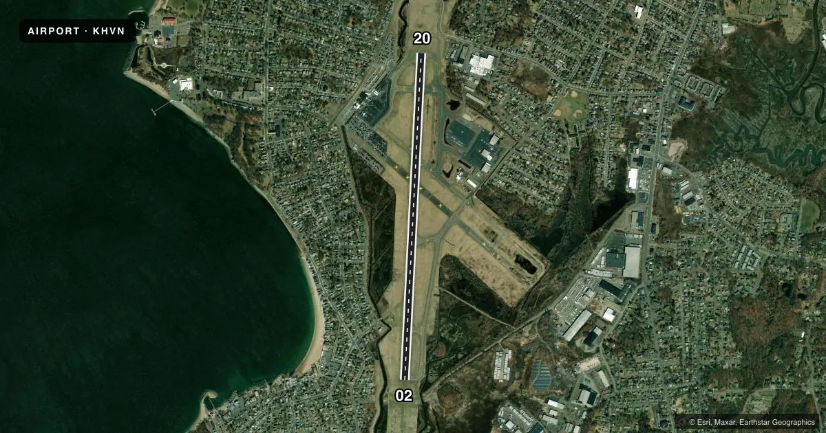
Runways & pattern
Full pagePattern entry · RWY 20
LEFT TRAFFICRunway end performance
| End | TORA | TODA | ASDA | LDA | VGSI | Approach lights | Obstruction |
|---|---|---|---|---|---|---|---|
| 02 | 5,600' | 5,600' | 5,600' | 5,600' | PAPI 4-box left(3°) | MALSF | 36', trees, 1400' from thr, 0' R of cntrln, slope 33 |
| 20 | 5,600' | 5,600' | 5,600' | 5,600' | PAPI 4-box left(3.5°) | — | 55', trees, 1300' from thr, 0' R of cntrln, slope 20 |
Declared distances in feet. TORA = takeoff run available, TODA = takeoff distance, ASDA = accelerate-stop, LDA = landing distance.
Airport sketch
Runways drawn to scale from FAA survey coordinates, rendered over satellite imagery. Not for navigation.
Approaches & charts
ILS · 1
Services on the field
Fuel grades, oxygen, maintenance, ramp storage and lighting — as declared to the FAA by the airport operator.
Fuel & services
- Fuel
- 100LLA
- Oxygen (bottled)
- High pressure
- Oxygen (bulk)
- High pressure
- Airframe repair
- Major
- Power plant repair
- Major
- Other services
- CHTR,INSTR,RNTL,SALES
Ramp & ground
- Transient storage
- Tie-down
- Hangar
- Landing fee
- Yes
- Customs
- Not available
- Lighting schedule
- SEE RMK
- Beacon schedule
- SS-SR
- Beacon
- White / Green (civil land)(WG)
- Wind indicator
- Lighted
- Segmented circle
- Yes
Fuel & FBOs
Cheapest 100LL and Jet A on the field and nearby. Always confirm with the FBO before taxi.
Airport notes
Surface conditions, obstructions, local procedures, lighting outages and other notes published with each FAA cycle.
General notes
- TGL OPNS PMTD 0700-2200 MON-SAT; 0800-2200 SUN.
- FLT NOTIFICATION SVC (ADCUS) AVBL.
- CLSD TO ACFT OVER 78 DB 0700-2200; 73 DB 2200-0000 & 0600-0700; 68 DB 0000-0600 EXCP MIL EMERG & MED ACFT; PPR CALL 203-907-9818.
- EXTSV HOP SFC-10000 FT WI 20 MI NNW.
- WILDLIFE FQTLY ON OR INVOF ARPT.
- TSNT PRKG ON EAST RAMP ONLY.
- PAEW ADJ TO ALL OPR SFCS DALGT HRS APR-OCT.
- LDG HELS USE TWYS A & H INTXN.
- STANDING WATER AT INTXN OF TWY D & C AFT HVY RAIN.
- FOR CD WHEN TWR CLSD CTC NEW YORK APCH AT 516-683-2449 OR 121.7.
- AVOID CLOSE-IN BASE LEGS AND SHORT APCHS LDG RWY 20.
- NOISE ABATEMENT PROCS IN EFCT. DEPARTING RWY 20, RIGHT AND LEFT TURN MADE ONLY AFT PASSING SHORELINE.
Lighting notes
- WHEN ATCT CLSD ACTVT MALSF RWY 02; HIRL RWY 02/20 - CTAF.
Runway surface & condition
- 02/20PCR VALUE: 320/F/B/X/T
Other notes
- EXISTED PRIOR TO 1959.
- ARFF INDEX C SVCS PRVDD BTN 0600 AND 2359 DLY. ARFF INDEX B SVCS PRVDD DRG OTR TIMES. FOR INDEX C SVCS BTN 0000 AND 0559, 1HR 30MIN PPR AT 203-907-9818.
- LDG FEE FOR ALL ACFT EXC MIL, GOVT, EMERG & MED.
- TPA: 999 FT AGL RECIPROCATING ENG, 1499 FT AGL TURBOPROP/JET.
- 1FUEL AVBL AFT HRS PPR 203-467-9555.
VFR map & nearby airports
VFR sectional. Tap any ICAO chip to open that airport.
Key facts · KHVN
Answer card- ICAO
- KHVN
- Name
- TWEED/NEW HAVEN
- Location
- NEW HAVEN, CONNECTICUT
- Elevation
- 12.6 ft MSL
- Traffic pattern altitude
- 1,011.6 ft MSL (999 AGL)
- Control tower
- Towered · 0600-2200
- Total runways
- 1
- Longest runway
- 02/20 · 5,600 ft
- Published ILS approaches
- 1
- Published frequencies
- 9
- Magnetic variation
- 13°
- Current flight rules
- VFR
- Current wind
- 170° at 4 kt
- Favored runway now
- RWY 20
Tweed/New Haven Airport is in New Haven, Connecticut. The field elevation is 12.6 ft MSL. KHVN has one runway, 02/20, which is 5,600 ft long with asphalt pavement. The tower is open daily from 0600 to 2200. One ILS approach is published for runway 02. Pattern altitude is 999 ft AGL, which is 1,011.6 ft MSL.
Robinson Aviation is on the field. It carries 100LL, Jet A and Jet A Prist. If you are planning a stop, transient parking is on the east ramp only. The airport also has published noise abatement procedures. Departures off runway 20 should keep turns straight ahead until past the shoreline. Avoid close-in base legs and short approaches to runway 20.
A few operational details matter here. Standing water can collect at the taxiway D and C intersection after heavy rain. Pavement next to the movement areas is often damp or wet from April through October during daylight hours. There is also heavy helicopter traffic in the area north-northwest of the field, up to 10,000 ft within 20 miles. When the tower is closed, clearance delivery goes through New York Approach. Check the current FAA Chart Supplement for the latest noise or curfew restrictions before flying in.