METAR & TAF 21N
21N does not publish a METAR.
Showing the nearest reporting station: KFOK (FRANCIS S GABRESKI) · 10.0 NM away. Conditions at 21N may differ.
METAR · KFOK
Observed 11:53Z
KFOK 271153Z 20004KT 10SM CLR 22/19 A2986 RMK AO2 SLP111 T02220189 10222 20128 53005
- Wind
- 200° @ 4 kt
- Visibility
- 10 SM
- Temp / Dew
- 22°C / 19°C
- Altimeter
- 29.86 inHg
- Clouds
- CLR
- Density alt
- 952 ft
- Ceiling
- Unlimited
- Rules
- VFR
Airport info & contacts
Manager on record, flight service, ARTCC, attendance schedule and pattern altitude — published by the FAA and refreshed every 28 days.
Location
- From city
- 1 NM SE
- VFR sectional
- NEW YORK
- ARTCC
- ZNY · NEW YORK
- NOTAM facility
- ISP (NOTAM-D)
Airport manager
- Name
- PAUL PAWLOWSKI
- Phone
- 631-445-4348
- Address
- 410 AIRWAY DRIVE, MATTITUCK NY 11952
Flight service · Hours
- FSS ISP
- NEW YORK1-800-WX-BRIEF
- Attendance
- UNATT
Frequencies
Tap any row to copy the frequency to your clipboard.
Runways & pattern
Full pagePattern entry · RWY 19
LEFT TRAFFICRunway end performance
| End | TORA | TODA | ASDA | LDA | VGSI | Approach lights | Obstruction |
|---|---|---|---|---|---|---|---|
| 01 | — | — | — | — | — | — | 44', trees, 209' from thr, 77' R of cntrln, slope 0 |
| 19 | — | — | — | — | — | — | 51', trees, 360' from thr, 117' R of cntrln, slope 3 |
Declared distances in feet. TORA = takeoff run available, TODA = takeoff distance, ASDA = accelerate-stop, LDA = landing distance.
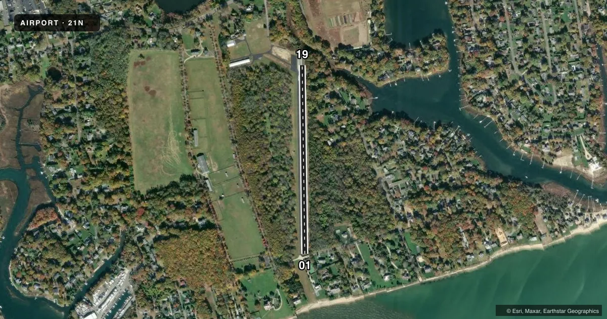
Airport sketch
Runways drawn to scale from FAA survey coordinates, rendered over satellite imagery. Not for navigation.
Approaches & charts
Services on the field
Fuel grades, oxygen, maintenance, ramp storage and lighting — as declared to the FAA by the airport operator.
Fuel & services
- Fuel
- Not available
- Oxygen (bottled)
- Not available
- Oxygen (bulk)
- Not available
- Airframe repair
- Not available
- Power plant repair
- Not available
Ramp & ground
- Transient storage
- Tie-down
- Hangar
- Landing fee
- No fee published
- Customs
- Not available
- Wind indicator
- Yes
- Segmented circle
- Yes
Fuel & FBOs
Cheapest 100LL and Jet A on the field and nearby. Always confirm with the FBO before taxi.
Airport notes
Surface conditions, obstructions, local procedures, lighting outages and other notes published with each FAA cycle.
General notes
- ALL TRNG OPNS; TKOF/LNDG PRACTICE AND NIGHT OPNS ARE PROHIBITED.
- SEGMENTED CIRCLE HAS NO TFC PATTERN INDICATOR.
- DEER ON & INVOF ARPT.
- FOR CD CTC NEW YORK APCH AT 516-683-2449.
- CALL AMGR FOR PMSN TO LND.
Approach & departure obstructions
- 01+5 FT FENCE & SHRUBS 0-200 FT FM THR ON BOTH SIDES OF RWY; +46 FT TREES 0-200 FT FM THR 75-120 FT R; +10 FT WIDE ROAD 0-20 FT FM BOTH SIDES OF RWY THR.
- 19+29 FT TREES 73 FT FM THR 38 FT R; +50 FT TREES 0 FT FM THR 64 FT L; +8 FT BERM 29-69 FT FM THR ON BOTH SIDES OF RWY.
- 01TWO STORY HOUSE 165 FT FM RWY THR, RIGHT OF CNTRLN.
- 01CTLNG OBSTN EXCEEDS 45 DEG SLP.
VFR map & nearby airports
VFR sectional. Tap any ICAO chip to open that airport.
Key facts · 21N
Answer card- ICAO
- 21N
- Name
- MATTITUCK
- Location
- MATTITUCK, NEW YORK
- Elevation
- 30 ft MSL
- Traffic pattern altitude
- 1,030 ft MSL (1,000 AGL)
- Control tower
- Non-towered (use CTAF)
- Total runways
- 1
- Longest runway
- 01/19 · 2,200 ft
- Published ILS approaches
- 0
- Published frequencies
- 1
- Magnetic variation
- 14°
- Current flight rules
- VFR
- Current wind
- 200° at 4 kt
- Favored runway now
- RWY 19
Mattituck Airport (21N) sits in Mattituck, New York on the North Fork of Long Island. Field elevation is 30 ft MSL. The airport has one runway, 01/19, which is 2,200 ft long and paved with asphalt. There is no control tower. CTAF is 122.9. No ILS approaches are published here.
Pattern altitude is not published. Use the standard 1,000 ft AGL pattern for light piston traffic unless the current Chart Supplement or the airport manager gives you different guidance. The published remarks matter here. Deer are reported on and near the airport. There are close-in trees, shrubs, a fence, a road and a house near the runway ends. The controlling obstacle at runway 01 end exceeds a 45-degree slope. The segmented circle has no traffic pattern indicator.
Operations are restricted. Call the airport manager for permission to land. Training operations, takeoff and landing practice and night operations are prohibited. For clearance delivery, contact New York Approach at 516-683-2449. With no on-field FBOs listed, plan ahead. Verify current services with the airport operator before you go.