METAR & TAF KMTP
Current METAR
Observed 13:54Z
KMTP 271354Z AUTO VRB03KT 22/15 A2986 RMK AO1 SLP112 T02220150 $
- Wind
- VAR @ 3 kt
- Visibility
- —
- Temp / Dew
- 22°C / 15°C
- Altimeter
- 29.86 inHg
- Clouds
- Clear
- Density alt
- 923 ft
- Ceiling
- Unlimited
- Rules
- VFR
Airport info & contacts
Manager on record, flight service, ARTCC, attendance schedule and pattern altitude — published by the FAA and refreshed every 28 days.
Location
- From city
- 3 NM NE
- VFR sectional
- NEW YORK
- ARTCC
- ZBW · BOSTON
- NOTAM facility
- MTP (NOTAM-D)
Airport manager
- Name
- NEIL BLANEY
- Phone
- 631-609-0932
- Address
- BOX 140, CENTERPORT NY 11721
Flight service · Hours
- FSS ISP
- NEW YORK1-800-WX-BRIEF
- Attendance
- APR-OCT · DALGT
Frequencies
Tap any row to copy the frequency to your clipboard.
Runways & pattern
Full pagePattern entry · RWY 06
LEFT TRAFFICRunway end performance
| End | TORA | TODA | ASDA | LDA | VGSI | Approach lights | Obstruction |
|---|---|---|---|---|---|---|---|
| 06 | — | — | — | — | PAPI 2-box right(3.83°) | — | 36', trees, 200' from thr, 238' R of cntrln, slope 0 |
| 24 | — | — | — | — | PAPI 2-box left(4°) | — | 40', hill, 208' from thr, 48' R of cntrln, slope 0 |
Declared distances in feet. TORA = takeoff run available, TODA = takeoff distance, ASDA = accelerate-stop, LDA = landing distance.
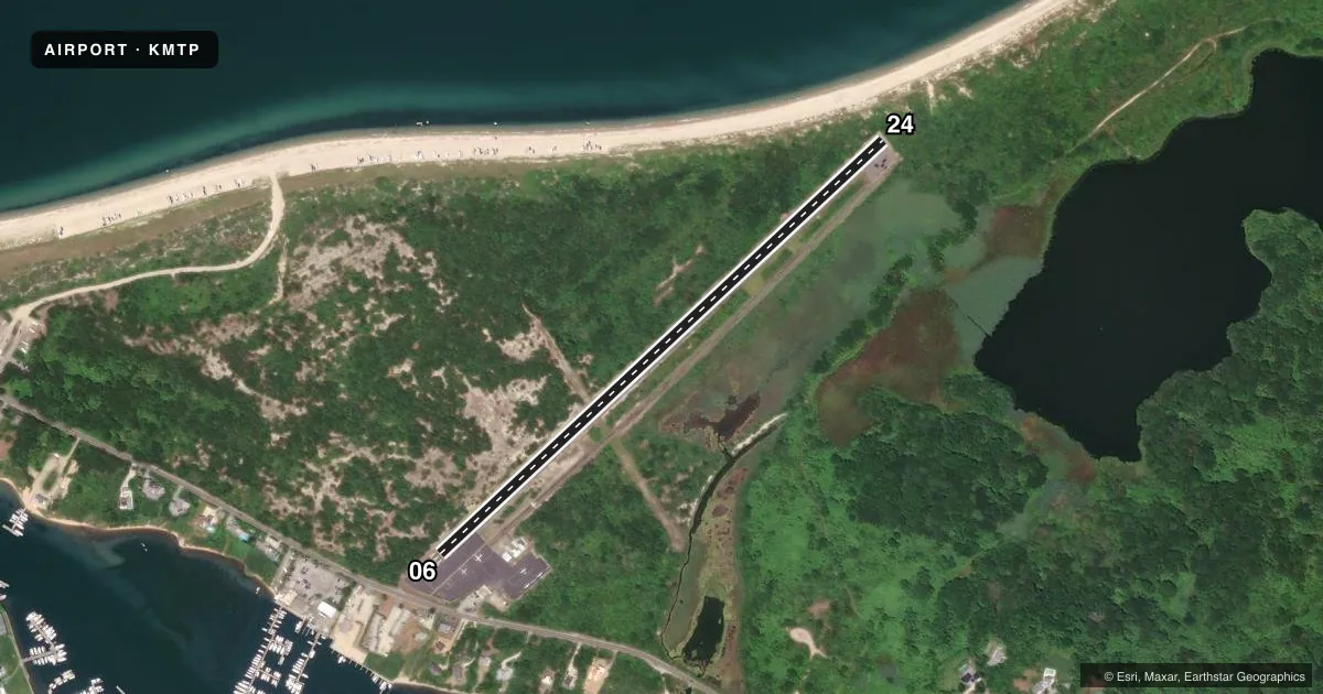
Airport sketch
Runways drawn to scale from FAA survey coordinates, rendered over satellite imagery. Not for navigation.
Approaches & charts
Services on the field
Fuel grades, oxygen, maintenance, ramp storage and lighting — as declared to the FAA by the airport operator.
Fuel & services
- Fuel
- Not available
- Oxygen (bottled)
- Not available
- Oxygen (bulk)
- Not available
- Airframe repair
- Not available
- Power plant repair
- Not available
Ramp & ground
- Transient storage
- Tie-down
- Landing fee
- Yes
- Customs
- Not available
- Lighting schedule
- SEE RMK
- Wind indicator
- Lighted
- Segmented circle
- No
Fuel & FBOs
Cheapest 100LL and Jet A on the field and nearby. Always confirm with the FBO before taxi.
Airport notes
Surface conditions, obstructions, local procedures, lighting outages and other notes published with each FAA cycle.
General notes
- PPR HEL OPNS SS-SR; CALL AMGR 631-668-3738.
- DEER ON OR INVOF ARPT.
- PPR JET ACFT; CALL AMGR 631-668-3738.
- HELICOPTERS CALL FOR PRIOR PERMISSION TO LND ON RAMP AREA.
- RWY 06; 18 FT BRUSH ALONG RWY EDGE 90 FT L; 30 FT POLE 400 FT FROM THLD 79 FT L; 31 FT POLE 216 FT FROM RWY THLD 233 FT R.
- RWY 06; 26 FT TREE 382 FT FROM THLD 21 FT L; 25-32 FT TREES 180-255 FT FROM THLD 60-90 FT L; 11-17 FT TREES 225-270 FT FROM THLD 4-95 FT R.
- RWY 24; 21 FT BRUSH ALONG RWY EDGE 87 FT R.
- NO TOUCH AND GOES RWY 06/24.
- NOISE ABATEMENT, RWY 24 DEP, RT ASAP.
- FOR CD CTC PROVIDENCE APCH AT 401-738-8945, WHEN APCH CLSD CTC BOSTON ARTCC AT 603-879-6859.
Lighting notes
- ACTVT MIRL & PAPI RWY 06/24 - 121.7.
Approach & departure obstructions
- 24RWY 24, 25FT - 35FT TREES AND TERRAIN, 0-200 FT FM RWY, 200 FT RT TO 250 FT LT.
- 06RWY 06, 5 FT FENCE, 200 FT FM THLD, 200 FT RT. 15 FT TREES, 117 FT FM THLD, 205 FT RT. 30 FT TREES, 0-200 FT FM THLD, 50 FT - 70 FT LT.
- 24NO TOUCH AND GO.
- 06PAPI RWY 6 TEMP OTS.
- 06RWY 06, 33 FT POLE, 212 FT FM RWY, 232 FT RT, CLNC SLP 15:1 TO DTHR. 15 FT ROAD 300 FT FM RWY, PERPENDICULAR TO EXTD RWY CNTRLN.
- 24CLNC SLP 21:1 TO DSPLCD THLD.
Other notes
- EXISTED PRIOR TO 1959.
- 1ATNDD APR 15 - OCT.
VFR map & nearby airports
VFR sectional. Tap any ICAO chip to open that airport.
Key facts · KMTP
Answer card- ICAO
- KMTP
- Name
- MONTAUK
- Location
- MONTAUK, NEW YORK
- Elevation
- 6.8 ft MSL
- Traffic pattern altitude
- 1,006.8 ft MSL (1,000 AGL)
- Control tower
- Non-towered (use CTAF)
- Total runways
- 1
- Longest runway
- 06/24 · 3,246 ft
- Published ILS approaches
- 0
- Published frequencies
- 6
- Magnetic variation
- 15°
- Current flight rules
- VFR
- Current wind
- 000° at 3 kt
- Favored runway now
- RWY 06
Montauk Airport sits in Montauk, New York at 6.8 ft MSL. It has one asphalt runway, 06/24, at 3,246 ft. The field is non-towered. Published frequencies include CTAF and UNICOM on 122.7. No ILS approaches are published. The pattern altitude is not published, so use the standard 1,000 ft AGL for light piston unless the current Chart Supplement says otherwise.
This is a coastal field with a short runway and several published obstacles close to the pavement. Runway 06 has trees near the departure path. Runway 24 has brush, trees and terrain near the edge. The clearance slope to the displaced threshold on 24 is also steep. The precision approach path indicator for runway 6 is temporarily out of service. Plan your stabilized approach carefully.
There are no on-field FBOs listed in the provided facts. Check with the airport operator or call the field directly before arrival for current services. The airport is attended from April 15 through October. Jet aircraft need prior permission. Helicopter operations need prior permission from sunset to sunrise. Helicopters also need prior permission to land on the ramp area. Noise abatement calls for right turns as soon as possible after departure from runway 24. Touch-and-go operations are not permitted on runway 24.