METAR & TAF KJPX
Current METAR
Observed 10:35Z
KJPX 271035Z AUTO 00000KT 10SM CLR 14/12 A2984 RMK AO2 T01400124
- Wind
- 000° @ 0 kt
- Visibility
- 10 SM
- Temp / Dew
- 14°C / 12°C
- Altimeter
- 29.84 inHg
- Clouds
- CLR
- Density alt
- 47 ft
- Ceiling
- Unlimited
- Rules
- VFR
Airport info & contacts
Manager on record, flight service, ARTCC, attendance schedule and pattern altitude — published by the FAA and refreshed every 28 days.
Location
- From city
- 3 NM W
- VFR sectional
- NEW YORK
- ARTCC
- ZNY · NEW YORK
- NOTAM facility
- JPX (NOTAM-D)
Airport manager
- Name
- JAMES BRUNDIGE
- Phone
- 631-537-1130
- Address
- 173 DANIELS HOLD RD, WAINSCOTT NY 11975
Flight service · Hours
- FSS ISP
- NEW YORK1-800-WX-BRIEF
Frequencies
Tap any row to copy the frequency to your clipboard.
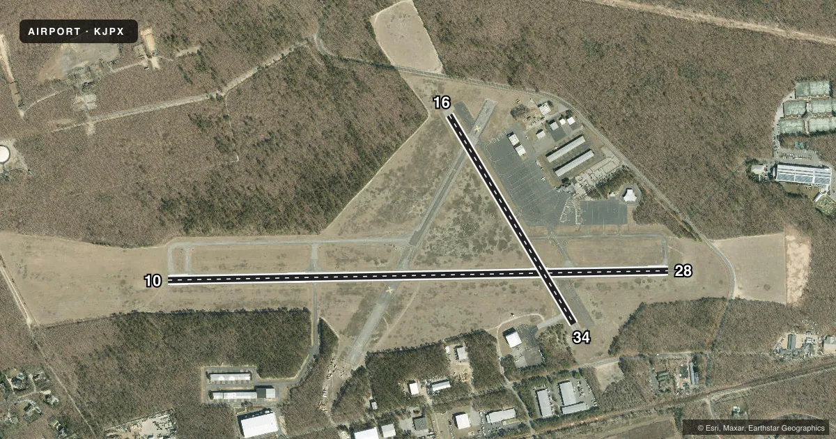
Runways & pattern
Full pagePattern entry · RWY 10
LEFT TRAFFIC| Runway | Heading (°M) | Length | Surface | Traffic |
|---|---|---|---|---|
| 10/28 | 76° / 256° | 4,255 ft | ASPH | Standard L |
| 16/34 | 136° / 316° | 2,060 ft | ASPH | Standard L |
Runway end performance
| End | TORA | TODA | ASDA | LDA | VGSI | Approach lights | Obstruction |
|---|---|---|---|---|---|---|---|
| 10 | — | — | — | — | PAPI 2-box left(3.3°) | — | 75', trees, 1359' from thr, 20' R of cntrln, slope 15 |
| 28 | — | — | — | — | PAPI 2-box right(3.8°) | — | 48', pole, 282' from thr, 254' R of cntrln, slope 1 |
| 16 | — | — | — | — | — | — | 15', road, 245' from thr, 0' R of cntrln, slope 3 |
| 34 | — | — | — | — | — | — | 45', trees, 699' from thr, 0' R of cntrln, slope 11 |
Declared distances in feet. TORA = takeoff run available, TODA = takeoff distance, ASDA = accelerate-stop, LDA = landing distance.
Airport sketch
Runways drawn to scale from FAA survey coordinates, rendered over satellite imagery. Not for navigation.
Approaches & charts
Services on the field
Fuel grades, oxygen, maintenance, ramp storage and lighting — as declared to the FAA by the airport operator.
Fuel & services
- Fuel
- 100LLA
- Oxygen (bottled)
- Not available
- Oxygen (bulk)
- Not available
- Airframe repair
- Major
- Power plant repair
- Major
- Other services
- CHTR,INSTR
Ramp & ground
- Transient storage
- Tie-down
- Hangar
- Landing fee
- Yes
- Lighting schedule
- SEE RMK
- Beacon schedule
- SS-SR
- Beacon
- White / Green (civil land)(WG)
- Wind indicator
- Lighted
- Segmented circle
- Yes
Fuel & FBOs
Cheapest 100LL and Jet A on the field and nearby. Always confirm with the FBO before taxi.
Airport notes
Surface conditions, obstructions, local procedures, lighting outages and other notes published with each FAA cycle.
General notes
- DEER ON & INVOF ARPT.
- REFER TO ARPT WEBSITE FOR DTLS ON CURRENT ARPT USAGE, RULES, NOISE ABMNT PCDRS AND REGS PRIOR TO ARR.
- FOR CD WHEN ATCT CLSD CTC NEW YORK APCH AT 516-683-2449.
- CTC FBO ON 122.85 FOR RAMP SVCS & PRKG.
Lighting notes
- ACTVT REIL RWY 28, MIRL RWY 10/28, TWY LGTS - CTAF. REIL RWY 10; PAPI RWY 10 & 28 OPR CONSLY.
Approach & departure obstructions
- 28+78 FT TREES, 850 FT FM THR BOTH SIDES CNTRLN; +15 FT ROAD, 491 FT FM THR BOTH SIDES CNTRLN.
Other notes
- LNDG FEE FOR ALL ACFT TO INCL TGL OPNS. CTC 1-800-588-0028.
- MANAGEREXT 5.
VFR map & nearby airports
VFR sectional. Tap any ICAO chip to open that airport.
Key facts · KJPX
Answer card- ICAO
- KJPX
- Name
- EAST HAMPTON TOWN
- Location
- EAST HAMPTON, NEW YORK
- Elevation
- 54.9 ft MSL
- Traffic pattern altitude
- 1,054.9 ft MSL (1,000 AGL)
- Control tower
- Towered · 0800-2000; OPRS SAT BFR MEMORIAL DAY TO SUN AFT LABOR DAY.
- Total runways
- 2
- Longest runway
- 10/28 · 4,255 ft
- Published ILS approaches
- 0
- Published frequencies
- 6
- Magnetic variation
- 13°
- Current flight rules
- VFR
- Current wind
- 000° at 0 kt
- Favored runway now
- –
East Hampton Town Airport sits in East Hampton, New York. Field elevation is 54.9 ft MSL. The airport has two asphalt runways. The longest is runway 10/28 at 4,255 ft. Runway 16/34 is 2,060 ft. The tower is open 0800-2000. It is open Saturdays before Memorial Day through Sunday after Labor Day. No ILS approaches are published here.
Pattern altitude is not published. Use 1,000 ft AGL for light piston operations unless the current Chart Supplement says otherwise. The field is close to deer habitat. Expect wildlife awareness on taxi, takeoff and landing. Published remarks also note trees and a road near the runway 28 threshold. That matters on short final and during go-arounds.
Runway 10/28 has medium intensity lights. Runway end identifier lights are on runway 10 and runway 28. Taxiway lights are controlled by CTAF. Precision approach path indicators operate continuously on runways 10 and 28. There are no on-field FBOs listed in the facts. Contact the airport operator or the FBO directly by phone for current ramp and parking support. Published remarks say to contact the FBO on 122.85 for ramp services and parking. For current rules, noise abatement and airport use, check the current Chart Supplement or the airport operator before you go.