METAR & TAF KISP
Current METAR
Observed 16:56Z
KISP 271656Z 19006KT 10SM SCT050TCU BKN090 BKN250 27/18 A2982 RMK AO2 SLP098 TCU W-NE T02670183
- Wind
- 190° @ 6 kt
- Visibility
- 10 SM
- Temp / Dew
- 27°C / 18°C
- Altimeter
- 29.82 inHg
- Clouds
- BKN
- Density alt
- 1,686 ft
- Ceiling
- 9,000 ft AGL
- Rules
- VFR
Airport info & contacts
Manager on record, flight service, ARTCC, attendance schedule and pattern altitude — published by the FAA and refreshed every 28 days.
Location
- From city
- 40 NM E
- VFR sectional
- NEW YORK
- ARTCC
- ZNY · NEW YORK
- NOTAM facility
- ISP (NOTAM-D)
Airport manager
- Name
- ROBERT A. SCHNEIDER
- Phone
- 631-467-3300
- Address
- 100 ARRIVAL AVE, RONKONKOMA NY 11779-7398
Flight service · Hours
- FSS ISP
- NEW YORK1-800-WX-BRIEF
- Attendance
- ALL
Frequencies
Tap any row to copy the frequency to your clipboard.
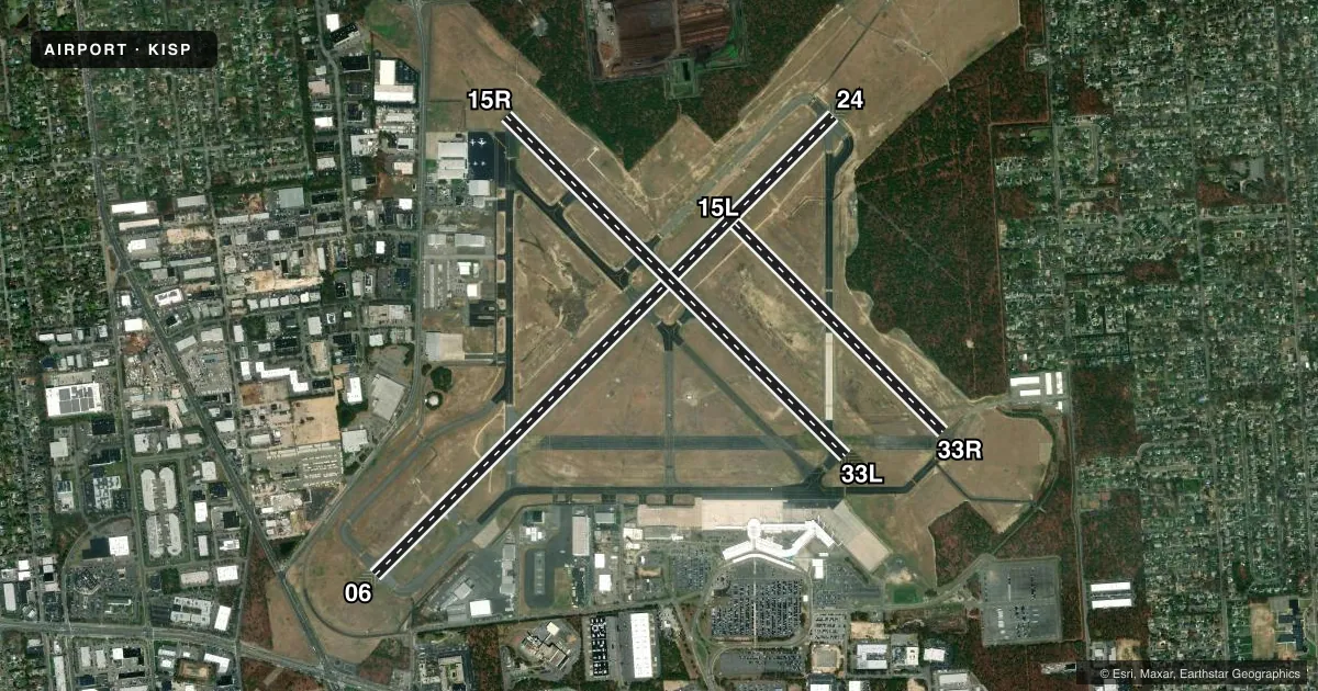
Runways & pattern
Full pagePattern entry · RWY 24
RIGHT TRAFFIC| Runway | Heading (°M) | Length | Surface | Traffic |
|---|---|---|---|---|
| 06/24Favored | 31° / 211° | 7,006 ft | ASPH | 24 R |
| 15R/33L | 121° / 301° | 5,186 ft | ASPH | 15R R |
| 15L/33R | 121° / 301° | 3,175 ft | ASPH | 33R R |
Runway end performance
| End | TORA | TODA | ASDA | LDA | VGSI | Approach lights | Obstruction |
|---|---|---|---|---|---|---|---|
| 06 | 7,006' | 7,006' | 7,006' | 7,006' | PAPI 4-box left(3°) | MALSR | 38', tree, 1340' from thr, 350' R of cntrln, slope 30 |
| 24 | 7,006' | 7,006' | 7,006' | 7,006' | PAPI 4-box left(3°) | MALSR | — |
| 15R | 5,186' | 5,186' | 5,186' | 5,186' | PAPI 4-box left(3.1°) | — | — |
| 33L | 5,186' | 5,186' | 5,186' | 5,186' | PAPI 4-box left(3°) | — | 39', trees, 1300' from thr, 300' R of cntrln, slope 28 |
| 15L | 3,175' | 3,175' | 3,175' | 3,175' | — | — | — |
| 33R | 3,175' | 3,175' | 3,175' | 3,175' | — | — | — |
Declared distances in feet. TORA = takeoff run available, TODA = takeoff distance, ASDA = accelerate-stop, LDA = landing distance.
Airport sketch
Runways drawn to scale from FAA survey coordinates, rendered over satellite imagery. Not for navigation.
Approaches & charts
ILS · 2
Services on the field
Fuel grades, oxygen, maintenance, ramp storage and lighting — as declared to the FAA by the airport operator.
Fuel & services
- Fuel
- 100LLA
- Oxygen (bottled)
- HIGH/LOW
- Oxygen (bulk)
- HIGH/LOW
- Airframe repair
- Major
- Power plant repair
- Major
- Other services
- AFRT,CHTR,INSTR,RNTL,SALES
Ramp & ground
- Transient storage
- Tie-down
- Hangar
- Landing fee
- Yes
- Customs
- Not available
- Lighting schedule
- SEE RMK
- Beacon schedule
- SS-SR
- Beacon
- White / Green (civil land)(WG)
- Wind indicator
- Yes
- Segmented circle
- Yes
Fuel & FBOs
Cheapest 100LL and Jet A on the field and nearby. Always confirm with the FBO before taxi.
Airport notes
Surface conditions, obstructions, local procedures, lighting outages and other notes published with each FAA cycle.
General notes
- ADZY:TFC LNDG RWY 33L HIGH DENSITY VFR TFC OPERG 600 FT MSL & BLW VCNTY BAYPORT AERODROME 3 MILES SE.
- BIRD ACTVTY ON & INVOF ARPT.
- TWY S UNLGTD EAST OF TRML APN.
- RWY 15L/33R CLSD TO FIXED WING ACFT AT NGT & AVBL FOR TXG.
- UPDRAFTS MAY BE ENCOUNTERED INVOF POWER PLANT 1.5 NM NE RWY 24.
- RWY 15L/33R NOT AVBL FOR NIGHT TKOF AND LDG OPS. LIMITED TO ACFT 48,000 LBS OR LESS.
- VOLUNTARY NS ABTMT PROCEDURES IN EFFECT FOR FIXED WING ACFT AND HELICOPTERS. CTC AIRPORT MANAGEMENT (631)467-3300.
- FOR CD WHEN ATCT CLSD CTC NEW YORK APCH AT 516-683-2449.
Lighting notes
- DUSK TO DAWN. WHEN ATCT CLSD ACTVT MIRL RWY 15R/33L; TWY LGTS- CTAF. HIRL RWY 06/24 PRESET LOW INTST ACTVT - CTAF; MALSR RWY 06 & 24 PRESET MED INTST FOR PREVAILING WIND RWY.
Runway surface & condition
- 06/24PCR VALUE: 550/F/A/X/T
- 15L/33RPCR VALUE: 280/F/B/X/T
- 15R/33LPCR VALUE: 590/F/B/X/T
- 15L/33RRWY 15L/33R NOT AVBL FOR PART 121/PART 380 OPS WITH SKED PAX CARRYING OPS MORE THAN 9 PAX SEATS AND NON-SKED PAX CARRYING OPS MORE THAN 30 PAX SEATS.
- H1LCTD ON TWY W SOUTH OF INT OF TWY B.
- H2LCTD ON TWY C NORTH OF TWY S.
Approach & departure obstructions
- 06NSTD MALSR; THREE OUTERMOST FLASHER LGTS EXCEED STD SPACING.
- 15LNSTD MKGS, THR BAR MISG ON RWY END.
- 33RNSTD MKGS, THR BAR MISG ON RWY END.
Other notes
- LDG FEE FOR ALL ACFT EXC MIL AND GOVT.
- LDG FEE FOR ALL ACFT EXC MIL, GOVT AND NOT-FOR-PROFIT MEDICAL FLIGHTS.
VFR map & nearby airports
VFR sectional. Tap any ICAO chip to open that airport.
Key facts · KISP
Answer card- ICAO
- KISP
- Name
- LONG ISLAND MAC ARTHUR
- Location
- NEW YORK, NEW YORK
- Elevation
- 98.7 ft MSL
- Traffic pattern altitude
- 1,098.7 ft MSL (1,000 AGL)
- Control tower
- Towered · 0600-2400
- Total runways
- 3
- Longest runway
- 06/24 · 7,006 ft
- Published ILS approaches
- 2
- Published frequencies
- 17
- Magnetic variation
- 14°
- Current flight rules
- VFR
- Current wind
- 190° at 6 kt
- Favored runway now
- RWY 24
Long Island Mac Arthur Airport is in New York, New York. Field elevation is 98.7 ft MSL. It has 3 asphalt runways. The longest is 06/24 at 7,006 ft. The airport has a control tower. Tower hours are 0600-2400.
Two ILS approaches are published here. They serve runway ends 06 and 24. Pattern altitude is not published in the facts, so use the standard 1,000 ft AGL for light piston traffic unless the current FAA Chart Supplement says otherwise. The field sits in busy Long Island airspace. Expect a lot of traffic flow. Stay sharp on taxi instructions.
On field FBOs are New York Jet and Modern Aviation. New York Jet carries 100LL, Jet A and Jet A Prist. Modern Aviation carries 100LL, Jet A and Jet A Prist. Published remarks also note that runway 06 has nonstandard approach lighting details. Taxiway S is unlighted east of the terminal apron. Updrafts may be encountered near the power plant 1.5 NM northeast of runway 24. Runway 33L traffic is part of a high density VFR area near Bayport Aerodrome. Check the current FAA Chart Supplement for any noise or curfew restrictions before flying into the field.