METAR & TAF 23N
23N does not publish a METAR.
Showing the nearest reporting station: KISP (LONG ISLAND MAC ARTHUR) · 3.2 NM away. Conditions at 23N may differ.
METAR · KISP
Observed 12:56Z
KISP 271256Z 00000KT 10SM FEW150 FEW250 24/18 A2984 RMK AO2 SLP103 T02390178
- Wind
- 000° @ 0 kt
- Visibility
- 10 SM
- Temp / Dew
- 24°C / 18°C
- Altimeter
- 29.84 inHg
- Clouds
- FEW
- Density alt
- 1,228 ft
- Ceiling
- Unlimited
- Rules
- VFR
Airport info & contacts
Manager on record, flight service, ARTCC, attendance schedule and pattern altitude — published by the FAA and refreshed every 28 days.
Location
- From city
- 1 NM NW
- VFR sectional
- NEW YORK
- Pattern altitude
- 600 ft AGL · 639 ft MSL
- ARTCC
- ZNY · NEW YORK
- NOTAM facility
- ISP (NOTAM-D)
Airport manager
- Name
- ROBERT SCHNEIDER
- Phone
- 631-467-3300
- Address
- 100 ARRIVAL AVE, SUITE 100, RONKONKOMA NY 11779
Flight service · Hours
- FSS ISP
- NEW YORK1-800-WX-BRIEF
- Attendance
- 0800-DUSK
Frequencies
Tap any row to copy the frequency to your clipboard.
Runways & pattern
Full pagePattern entry · RWY 18
RIGHT TRAFFICRunway end performance
| End | TORA | TODA | ASDA | LDA | VGSI | Approach lights | Obstruction |
|---|---|---|---|---|---|---|---|
| 18 | — | — | — | — | — | — | 51', trees, 355' from thr, 129' R of cntrln, slope 6 |
| 36 | — | — | — | — | — | — | 52', trees, 10' from thr, 40' R of cntrln, slope 0 |
Declared distances in feet. TORA = takeoff run available, TODA = takeoff distance, ASDA = accelerate-stop, LDA = landing distance.
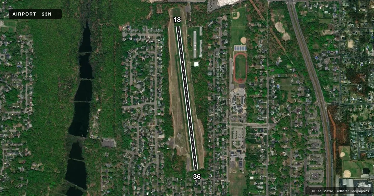
Airport sketch
Runways drawn to scale from FAA survey coordinates, rendered over satellite imagery. Not for navigation.
Approaches & charts
Services on the field
Fuel grades, oxygen, maintenance, ramp storage and lighting — as declared to the FAA by the airport operator.
Fuel & services
- Fuel
- Not available
- Oxygen (bottled)
- Not available
- Oxygen (bulk)
- Not available
- Other services
- INSTR
Ramp & ground
- Transient storage
- Tie-down
- Landing fee
- No fee published
- Customs
- Not available
- Wind indicator
- Yes
- Segmented circle
- Yes
Fuel & FBOs
Cheapest 100LL and Jet A on the field and nearby. Always confirm with the FBO before taxi.
Airport notes
Surface conditions, obstructions, local procedures, lighting outages and other notes published with each FAA cycle.
General notes
- ALL TFC ENTER 45 DEG LEFT BASE FOR RWY36 AT 600 MSL DUE HEAVY JET TFC RWY 33L AT ISP. ALL TFC ENTER 45 DEG RIGHT. DOWNWIND RWY 18 OVER LAKES AT 600 MSL DUE HEAVY JET TFC LNDG RWY 33L AT ISP.
- ALL DOWNWIND SPACING FOR RWY 18/36 S/B OVER LAKES FOR NOISE ABATEMENT.
- PHONE AT ARPT 631-467-3279.
- NO CLSD TFC PATTERN OR TOUCH AND GO LNDGS.
- ARPT CLSD 30 MIN AFTER SS TIL 30 MIN BEFORE SR.
- PILOTS BE ADVISED: DUE TO PATTERN PROCEDURES, AIRCRAFT IN THE RUN-UP AREA OR STARTING TAKEOFF ROLL ON RY 36, AND AIRCRAFT ON FINAL APPROACH TO RY 36, MAY NOT BE ABLE TO SEE EACH OTHER DUE TO TREES.
- FOR CD CTC NEW YORK APCH AT 516-683-2449.
Runway surface & condition
- 18/36RWY 18/36: WEST 75 FT WIDTH OPEN MAY-SEPT, EAST 75 FT WIDTH OPEN OCT-APR.
Approach & departure obstructions
- 36RWY 36 THLD MKD WITH 1 FT WIDE APN AND 2 FT WIDE THRD (WHITE) BOTH MADE WITH CONC BLOCKS FLUSH WITH TURF SFC.
- 18RWY 18 THLD MKD WITH CONC BLOCKS FLUSH WITH TURF SFC.
- 36RWY 36 THLD AND DTHR MKD WITH CONCRETE BLOCKS FLUSH WITH TURF SFC.
- 18RWY 36 CLNC SLOPE 10:1 TO DTHR.
- 36CTLG OBSTN EXCEEDS A 45 DEG SLP.
VFR map & nearby airports
VFR sectional. Tap any ICAO chip to open that airport.
Key facts · 23N
Answer card- ICAO
- 23N
- Name
- BAYPORT AERODROME
- Location
- BAYPORT, NEW YORK
- Elevation
- 39.2 ft MSL
- Traffic pattern altitude
- 639.2 ft MSL (600 AGL)
- Control tower
- Non-towered (use CTAF)
- Total runways
- 1
- Longest runway
- 18/36 · 2,750 ft
- Published ILS approaches
- 0
- Published frequencies
- 2
- Magnetic variation
- 13°
- Current flight rules
- VFR
- Current wind
- 000° at 0 kt
- Favored runway now
- –
Bayport Aerodrome sits in Bayport, New York. Field elevation is 39.2 ft MSL. It has one runway, 18/36 and the longest runway is 2,750 ft of turf. There is no control tower. CTAF and UNICOM are both 122.7. No ILS approaches are published.
Pattern altitude is 600 ft AGL. That puts the pattern at 639.2 ft MSL. The published traffic flow is not standard. Arrivals for runway 36 use a 45 degree left base at 600 MSL. Arrivals for runway 18 use a 45 degree right downwind over the lakes at 600 MSL. The remarks also call out heavy jet traffic on runway 33L at ISP. Expect to stay sharp in the pattern. Trees can block sight lines between the run-up area, the takeoff roll on runway 36 and final to runway 36.
No on-field FBOs are listed. Check with the airport operator before you go. The field is closed 30 minutes after sunset until 30 minutes before sunrise. Closed traffic and touch-and-go landings are not permitted. Runway 18/36 also has seasonal width changes. For clearance delivery, contact New York Approach at 516-683-2449.