METAR & TAF KHWV
Current METAR
Observed 09:56Z
KHWV 270956Z AUTO 00000KT 10SM CLR 16/15 A2984 RMK AO2 SLP102 T01560150 PWINO $
- Wind
- 000° @ 0 kt
- Visibility
- 10 SM
- Temp / Dew
- 16°C / 15°C
- Altimeter
- 29.84 inHg
- Clouds
- CLR
- Density alt
- 320 ft
- Ceiling
- Unlimited
- Rules
- VFR
Airport info & contacts
Manager on record, flight service, ARTCC, attendance schedule and pattern altitude — published by the FAA and refreshed every 28 days.
Location
- From city
- 1 NM N
- VFR sectional
- NEW YORK
- ARTCC
- ZNY · NEW YORK
- NOTAM facility
- HWV (NOTAM-D)
Airport manager
- Name
- DAVID MORAN
- Phone
- 631-451-6299
- Address
- 135 DAWN DRIVE, SHIRLEY NY 11967
Flight service · Hours
- FSS ISP
- NEW YORK1-800-WX-BRIEF
- Attendance
- 0700-1900
Frequencies
Tap any row to copy the frequency to your clipboard.
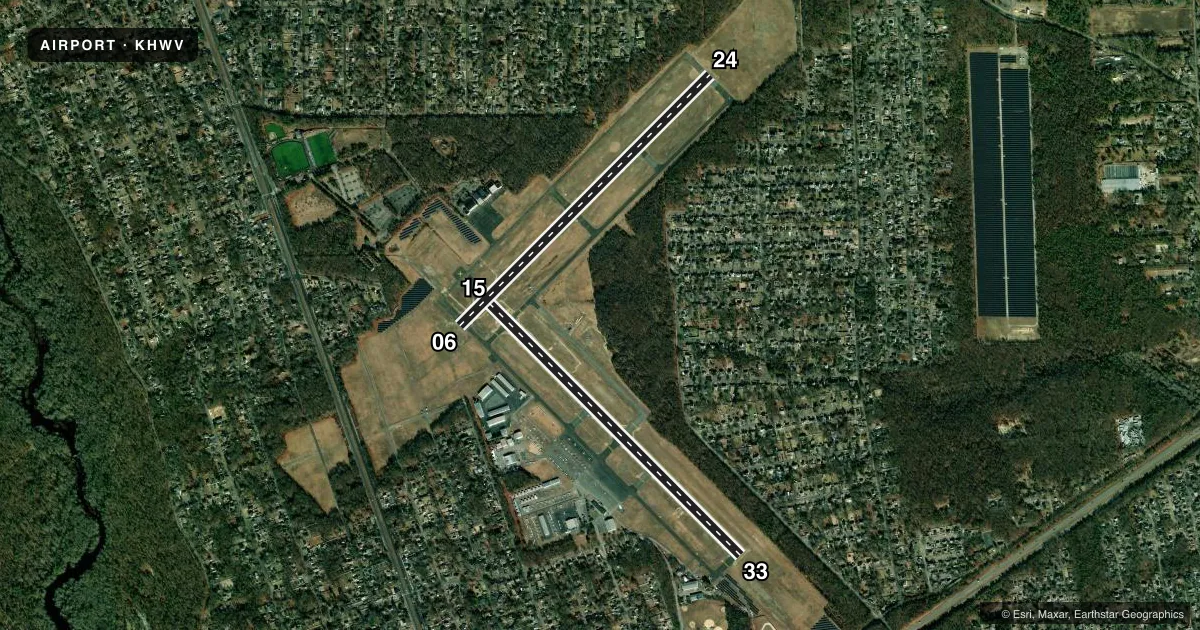
Runways & pattern
Full pagePattern entry · RWY 15
LEFT TRAFFIC| Runway | Heading (°M) | Length | Surface | Traffic |
|---|---|---|---|---|
| 15/33 | 121° / 301° | 4,222 ft | ASPH-CONC | Standard L |
| 06/24 | 31° / 211° | 4,201 ft | ASPH | Standard L |
Runway end performance
| End | TORA | TODA | ASDA | LDA | VGSI | Approach lights | Obstruction |
|---|---|---|---|---|---|---|---|
| 15 | — | — | — | — | PAPI 2-box left(3°) | — | 75', trees, 1349' from thr, 100' R of cntrln, slope 15 |
| 33 | — | — | — | — | PAPI 2-box left(3°) | — | 126', trees, 1671' from thr, 233' R of cntrln, slope 11 |
| 06 | — | — | — | — | VASI 4-box left(3°) | MALSR | 118', trees, 1446' from thr, 663' R of cntrln, slope 10 |
| 24 | — | — | — | — | — | — | 54', trees, 302' from thr, 332' R of cntrln, slope 1 |
Declared distances in feet. TORA = takeoff run available, TODA = takeoff distance, ASDA = accelerate-stop, LDA = landing distance.
Airport sketch
Runways drawn to scale from FAA survey coordinates, rendered over satellite imagery. Not for navigation.
Approaches & charts
ILS · 1
Services on the field
Fuel grades, oxygen, maintenance, ramp storage and lighting — as declared to the FAA by the airport operator.
Fuel & services
- Fuel
- 100LLA
- Oxygen (bottled)
- Not available
- Oxygen (bulk)
- Not available
- Airframe repair
- Major
- Power plant repair
- Major
- Other services
- CHTR,GLD,INSTR,RNTL,SALES,TOW
Ramp & ground
- Transient storage
- Tie-down
- Hangar
- Landing fee
- Yes
- Customs
- Not available
- Lighting schedule
- SEE RMK
- Beacon schedule
- SS-SR
- Beacon
- White / Green (civil land)(WG)
- Wind indicator
- Lighted
- Segmented circle
- Yes
Fuel & FBOs
Cheapest 100LL and Jet A on the field and nearby. Always confirm with the FBO before taxi.
Airport notes
Surface conditions, obstructions, local procedures, lighting outages and other notes published with each FAA cycle.
General notes
- GLIDER OPNS DALGT HOURS.
- GLIDERS USE RIGHT TRAFFIC PATTERN FOR RYS 24 & 33; GLIDERS USE LEFT TRAFFIC PATTERN FOR RYS 06 & 15
- UPPER AIR OBSERVATION BALLOONS LAUNCHED 3 MI NORTH OF ARPT 0600 & 1800.
- PILOTS BE AWARE WHEN CONDUCTING PRACTICE ILS APCHS: EXTENSIVE LIGHT ACFT TRAINING ON & INVOF ARPT ALL HRS.
- DEER ALL AREAS OF ARPT ESPECIALLY AT NIGHT.
- OVERNIGHT RAMP PARKING $5.00.
- EXTENSIVE PARACHUTE JUMPING ACTIVITY INVOF ARPT.
- ALL TWY LIGHTS OPR.
- FOR CD CTC NEW YORK APCH AT 516-683-2449 OR 133.2
- TGL ON HOL, WKENDS & NON-DALGT HRS NOT RCMDD.
- RELOCATED THRESHOLD IS TAXIWAY Z1
- DINER/LUNCHEONETTE OPN 7 DAYS/WEEK 0700-1600.
Lighting notes
- ACTVT MALSR RWY 06; REIL RWYS 24, 15, & 33; PAPI RWYS 15 & 33; MIRL RWYS 06/24 & 15/33 - CTAF.
Other notes
- LNDG FEES VARY. SEE ARPT WEBSITE FOR MORE INFO.
- MANAGERALTN PHONE 631-451-6291 OR 631-451-6299.
VFR map & nearby airports
VFR sectional. Tap any ICAO chip to open that airport.
Key facts · KHWV
Answer card- ICAO
- KHWV
- Name
- BROOKHAVEN
- Location
- SHIRLEY, NEW YORK
- Elevation
- 81.3 ft MSL
- Traffic pattern altitude
- 1,081.3 ft MSL (1,000 AGL)
- Control tower
- Non-towered (use CTAF)
- Total runways
- 2
- Longest runway
- 15/33 · 4,222 ft
- Published ILS approaches
- 1
- Published frequencies
- 5
- Magnetic variation
- 14°
- Current flight rules
- VFR
- Current wind
- 000° at 0 kt
- Favored runway now
- –
Brookhaven Airport (KHWV) sits in Shirley, New York. Field elevation is 81.3 ft MSL. The airport has two runways. The longest is 4,222 ft. Runway 15/33 is asphalt-concrete. Runway 06/24 is asphalt. The field is not towered, so use CTAF 122.8 for local traffic. Pattern altitude is not published. Use the standard 1,000 ft AGL pattern unless current local guidance says otherwise. That puts the light piston pattern at about 1,081 ft MSL.
An ILS is available on runway 06. Runway 06 also has MALSR lighting. Runway end identifier lights are on 24, 15 and 33. PAPI is on 15 and 33. Medium intensity runway lights are on both runways. Published remarks also note glider traffic. Gliders use the right pattern for 24 and 33. They use the left pattern for 06 and 15. Touch-and-goes are not recommended on holidays, weekends, or during non-daylight hours. Upper air observation balloons are launched three miles north of the airport at 0600 and 1800. Expect a busy training environment. Northeast Aviation Services is on the field. It carries 100LL and Jet A. For clearance delivery, contact New York Approach on 133.2 or by phone before departure.