METAR & TAF KSNC
Current METAR
Observed 17:15Z
KSNC 271715Z AUTO 15006KT 10SM CLR 28/19 A2984 RMK AO2
- Wind
- 150° @ 6 kt
- Visibility
- 10 SM
- Temp / Dew
- 28°C / 19°C
- Altimeter
- 29.84 inHg
- Clouds
- CLR
- Density alt
- 2,175 ft
- Ceiling
- Unlimited
- Rules
- VFR
Airport info & contacts
Manager on record, flight service, ARTCC, attendance schedule and pattern altitude — published by the FAA and refreshed every 28 days.
Location
- From city
- 3 NM SW
- VFR sectional
- NEW YORK
- ARTCC
- ZNY · NEW YORK
- NOTAM facility
- SNC (NOTAM-D)
Airport manager
- Name
- CHARLES F. GREENEY, JR.
- Phone
- 860-718-2109
- Address
- WHELEN ENGINEERING, 51 WINTHROP ROAD, CHESTER CT 06412
Flight service · Hours
- FSS BDR
- BRIDGEPORT1-800-WX-BRIEF
- Attendance
- APR-OCT · 0900-2000
- NOV-MAR · 0900-1800
Frequencies
Tap any row to copy the frequency to your clipboard.
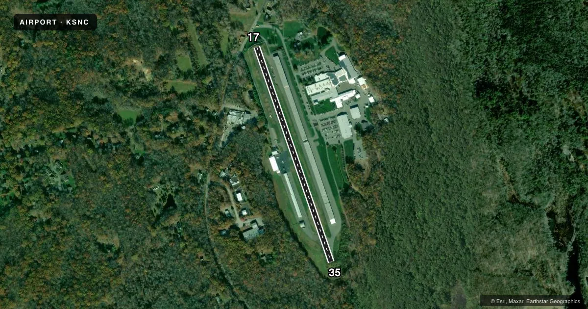
Runways & pattern
Full pagePattern entry · RWY 17
LEFT TRAFFICRunway end performance
| End | TORA | TODA | ASDA | LDA | VGSI | Approach lights | Obstruction |
|---|---|---|---|---|---|---|---|
| 17 | — | — | — | — | — | — | 50', tree, 207' from thr, 66' R of cntrln, slope 1 |
Declared distances in feet. TORA = takeoff run available, TODA = takeoff distance, ASDA = accelerate-stop, LDA = landing distance.
Airport sketch
Runways drawn to scale from FAA survey coordinates, rendered over satellite imagery. Not for navigation.
Approaches & charts
Services on the field
Fuel grades, oxygen, maintenance, ramp storage and lighting — as declared to the FAA by the airport operator.
Fuel & services
- Fuel
- 100LL
- Oxygen (bottled)
- Not available
- Oxygen (bulk)
- Not available
- Airframe repair
- Major
- Power plant repair
- Major
- Other services
- AFRT,AVNCS,CHTR,INSTR,RNTL,SALES
Ramp & ground
- Transient storage
- Tie-down
- Hangar
- Customs
- Not available
- Lighting schedule
- SS-SR
- Beacon schedule
- SS-SR
- Beacon
- White / Green (civil land)(WG)
- Wind indicator
- Lighted
- Segmented circle
- No
Fuel & FBOs
Cheapest 100LL and Jet A on the field and nearby. Always confirm with the FBO before taxi.
Airport notes
Surface conditions, obstructions, local procedures, lighting outages and other notes published with each FAA cycle.
General notes
- FOR CD CTC NEW YORK APCH AT 516-683-2449.
Lighting notes
- ROTG BCN OPRS 24/7.
Fuel notes
- 100LLSELF SVC FUEL AVBL WITH CREDIT CARD.
Runway surface & condition
- 17/35NON-STD MIRL FIXTURES/CONES.
Approach & departure obstructions
- 17+5 FT TREE 56 FT DSTC, 60 FT L.
- 35+3 FT BRUSH, 0 FT FM THR, 103 FT R.
- 17DSPLCD THR 5 FT HYR THAN AER.
- 17DSPLCD THR MARKED BUT NOT LGTD.
- 17OBSTN CLNC SLOPE 14:1 TO DTHR.
Other notes
- EXISTED PRIOR TO 1959.
- NO ROPES PRVDD.
- MANAGERCELL 860-853-0993.
VFR map & nearby airports
VFR sectional. Tap any ICAO chip to open that airport.
Key facts · KSNC
Answer card- ICAO
- KSNC
- Name
- CHESTER
- Location
- CHESTER, CONNECTICUT
- Elevation
- 416 ft MSL
- Traffic pattern altitude
- 1,416 ft MSL (1,000 AGL)
- Control tower
- Non-towered (use CTAF)
- Total runways
- 1
- Longest runway
- 17/35 · 2,722 ft
- Published ILS approaches
- 0
- Published frequencies
- 4
- Magnetic variation
- 13°
- Current flight rules
- VFR
- Current wind
- 150° at 6 kt
- Favored runway now
- RWY 17
Chester Airport is in Chester, Connecticut. The field elevation is 416 ft MSL. It has one runway, 17/35, which is 2,722 ft long. There is no control tower. The rotating beacon runs 24 hours a day. Pattern altitude is not published, so use the standard 1,000 ft AGL for light piston operations unless the current Chart Supplement says otherwise.
No ILS approaches are published here. For IFR work, plan around the current published procedures and coordinate with New York Approach if needed. The airport has published frequencies for New York Approach and Departure on 124.075 and 343.65. CTAF and UNICOM are both 122.725.
Chester Charter is on the field. It carries AVGAS 100LL. Self-service 100LL is available with credit card. Published remarks also note non-standard medium intensity runway lighting on 17/35. The displaced threshold on Runway 17 is marked but not lighted. There are published obstructions near both ends. Runway 17 has a 5-foot tree 56 feet from the runway and 60 feet left. Runway 35 has a 3-foot brush obstruction at the threshold area, 103 feet right. The airport sits in a low-elevation Connecticut setting. The main pilot concerns are runway length, obstacle awareness and using current published data before arrival.