METAR & TAF 0B8
0B8 does not publish a METAR.
Showing the nearest reporting station: KGON (GROTON-NEW LONDON) · 4.7 NM away. Conditions at 0B8 may differ.
METAR · KGON
Observed 11:56Z
KGON 271156Z 00000KT 10SM CLR 18/15 A2985 RMK AO2 SLP107 T01830150 10183 20139 53008
- Wind
- 000° @ 0 kt
- Visibility
- 10 SM
- Temp / Dew
- 18°C / 15°C
- Altimeter
- 29.85 inHg
- Clouds
- CLR
- Density alt
- 456 ft
- Ceiling
- Unlimited
- Rules
- VFR
Airport info & contacts
Manager on record, flight service, ARTCC, attendance schedule and pattern altitude — published by the FAA and refreshed every 28 days.
Location
- From city
- 8 NM SE
- VFR sectional
- NEW YORK
- ARTCC
- ZBW · BOSTON
- NOTAM facility
- BDR (NOTAM-D)
Airport manager
- Name
- DAVID MCCALL
- Phone
- 917-675-0296
- Address
- PO BOX 607, 261 TRUMBULL DR, FISHERS ISLAND NY 06390
Flight service · Hours
- FSS BDR
- BRIDGEPORT1-800-WX-BRIEF
- Attendance
- MAY-OCT · SUN · 1000-1630
- MAY-OCT · MON-SAT · 0800-1630
- 1 NOV-30 APR · Unattended
Frequencies
Tap any row to copy the frequency to your clipboard.
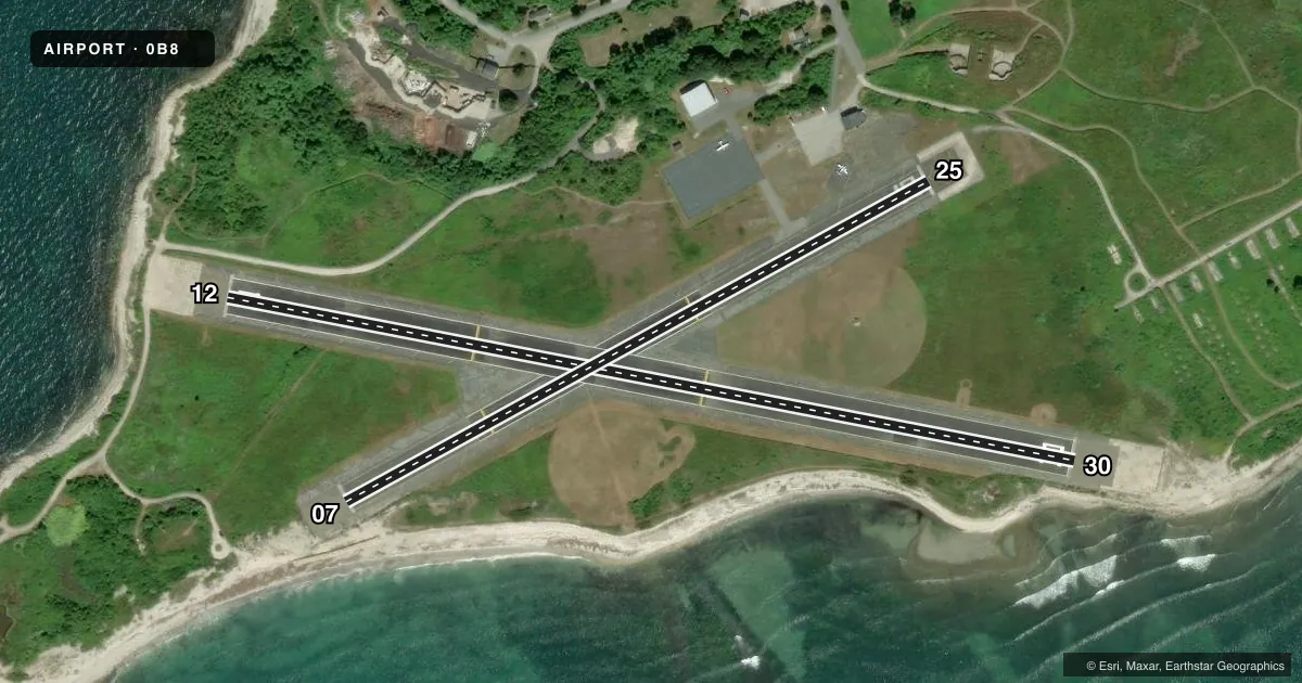
Runways & pattern
Full pagePattern entry · RWY 12
LEFT TRAFFIC| Runway | Heading (°M) | Length | Surface | Traffic |
|---|---|---|---|---|
| 12/30 | 87° / 267° | 2,345 ft | ASPH | Standard L |
| 07/25 | 47° / 227° | 1,806 ft | ASPH | Standard L |
Runway end performance
| End | TORA | TODA | ASDA | LDA | VGSI | Approach lights | Obstruction |
|---|---|---|---|---|---|---|---|
| 12 | — | — | — | — | PAPI 2-box left(3°) | — | 15', road, 200' from thr, slope 0 |
| 30 | — | — | — | — | PAPI 2-box right(3°) | — | 5', other, 200' from thr, 78' R of cntrln, slope 0 |
| 07 | — | — | — | — | PAPI 2-box left(3.75°) | — | 30', gnd, 363' from thr, 141' R of cntrln, slope 5 |
| 25 | — | — | — | — | PAPI 2-box left(3°) | — | 10', road, 246' from thr, 22' R of cntrln, slope 4 |
Declared distances in feet. TORA = takeoff run available, TODA = takeoff distance, ASDA = accelerate-stop, LDA = landing distance.
Airport sketch
Runways drawn to scale from FAA survey coordinates, rendered over satellite imagery. Not for navigation.
Approaches & charts
Services on the field
Fuel grades, oxygen, maintenance, ramp storage and lighting — as declared to the FAA by the airport operator.
Fuel & services
- Fuel
- Not available
- Oxygen (bottled)
- Not available
- Oxygen (bulk)
- Not available
- Airframe repair
- Not available
- Power plant repair
- Not available
Ramp & ground
- Transient storage
- Tie-down
- Landing fee
- Yes
- Customs
- Not available
- Lighting schedule
- SEE RMK
- Wind indicator
- Lighted
- Segmented circle
- No
Fuel & FBOs
Cheapest 100LL and Jet A on the field and nearby. Always confirm with the FBO before taxi.
Airport notes
Surface conditions, obstructions, local procedures, lighting outages and other notes published with each FAA cycle.
General notes
- (A17) ARPT ATTENDED MAY-OCT MON THRU SAT 0800-1630; SUN 1000-1630; UNATNDD NOV-APR.
- FOR CD CTC PROVIDENCE APCH AT 401-738-8945, WHEN APCH CLSD CTC BOSTON ARTCC AT 603-879-6859.
Lighting notes
- ACTVT REIL RY 07/25 & RY 12/30; PAPI RY 07/25 & RY 12/30; MIRL RY 07/25 & RY 12/30 - CTAF.
Approach & departure obstructions
- 07RWY 07; 6 FT ROCK/GRAVEL DUNE PARALLEL TO RWY 75 FT R. 6 FT ROCK/GRAVEL DUNE 165 FT FROM RWY PERPENDICULAR TO RWY.
- 12RWY12; +15FT RD PARALLEL TO RWY 90 FT L.
- 25RWY 25; +7 FT BRUSH 170-180 FT FROM THLD 42-61 FT L.
- 0724 FT DUNE.
- 12RY 12, 2.5 FT SIGN POST 202 FT FM THLD 87 FT RT; 2.5 FT SIGN POS , 202 FT FM THLD 78 FT L.
- 30RY 30, 5 FT ROCK SEAWALL 70-85 FT L PARALLEL TO RY.
Other notes
- APR 16, 1959 MIL FAC TURNED OVER TO COM.
- MANAGEROR 860-460-7174 WHEN ATTENDED.
VFR map & nearby airports
VFR sectional. Tap any ICAO chip to open that airport.
Key facts · 0B8
Answer card- ICAO
- 0B8
- Name
- ELIZABETH FLD
- Location
- FISHERS ISLAND, NEW YORK
- Elevation
- 7.2 ft MSL
- Traffic pattern altitude
- 1,007.2 ft MSL (1,000 AGL)
- Control tower
- Non-towered (use CTAF)
- Total runways
- 2
- Longest runway
- 12/30 · 2,345 ft
- Published ILS approaches
- 0
- Published frequencies
- 4
- Magnetic variation
- 14°
- Current flight rules
- VFR
- Current wind
- 000° at 0 kt
- Favored runway now
- –
Elizabeth Fld (0B8) sits on Fishers Island in New York. Field elevation is 7.2 ft MSL. The airport has 2 asphalt runways. The longest is 2,345 ft on runway 12/30. There is no control tower. The field is attended May through October. Hours are Monday through Saturday from 0800 to 1630. Sunday hours are 1000 to 1630. It is unattended November through April.
No ILS approaches are published here. Traffic pattern altitude is not published, so use the standard 1,000 ft AGL for light piston operations unless the current FAA Chart Supplement says otherwise. CTAF and UNICOM are both 122.8. Providence Approach handles the published approach and departure frequencies. For clearance delivery, contact Providence Approach. When Providence Approach is closed, contact Boston ARTCC.
There are no on-field FBOs listed. Plan on coordinating directly with the airport manager before arrival if you need local handling. Published remarks also call out several runway-adjacent obstructions. Runway 07 has dunes near the runway. Runway 25 has brush near the threshold. Runway 12 has a road and sign posts close to the runway. Runway 30 has a rock seawall off the left side. The field is low and coastal, so expect a short-field environment with limited margin. Check the current FAA Chart Supplement for any noise or operational restrictions before you go.