METAR & TAF 08R
08R does not publish a METAR.
Showing the nearest reporting station: KOQU (QUONSET STATE) · 11.4 NM away. Conditions at 08R may differ.
METAR · KOQU
Observed 12:50Z
KOQU 271250Z 00000KT 10SM BKN100 20/12 A2984
- Wind
- 000° @ 0 kt
- Visibility
- 10 SM
- Temp / Dew
- 20°C / 12°C
- Altimeter
- 29.84 inHg
- Clouds
- BKN
- Density alt
- 861 ft
- Ceiling
- 10,000 ft AGL
- Rules
- VFR
Airport info & contacts
Manager on record, flight service, ARTCC, attendance schedule and pattern altitude — published by the FAA and refreshed every 28 days.
Location
- From city
- 3 NM W
- VFR sectional
- NEW YORK
- ARTCC
- ZBW · BOSTON
- NOTAM facility
- BDR (NOTAM-D)
Airport manager
- Name
- JACK GORDON
- Phone
- 401-783-1498
- Address
- 23 HEATON ORCHARD RD, WEST KINGSTON RI 02892
Flight service · Hours
- FSS BDR
- BRIDGEPORT1-800-WX-BRIEF
- Attendance
- 0900-1700
Frequencies
Tap any row to copy the frequency to your clipboard.
Runways & pattern
Full pagePattern entry · RWY 11
LEFT TRAFFICRunway end performance
| End | TORA | TODA | ASDA | LDA | VGSI | Approach lights | Obstruction |
|---|---|---|---|---|---|---|---|
| 11 | — | — | — | — | — | — | 45', trees, 600' from thr, 45' R of cntrln, slope 8 |
| 29 | — | — | — | — | TRIL(5.5°) | — | 65', tree, 200' from thr, 45' R of cntrln, slope 0 |
Declared distances in feet. TORA = takeoff run available, TODA = takeoff distance, ASDA = accelerate-stop, LDA = landing distance.
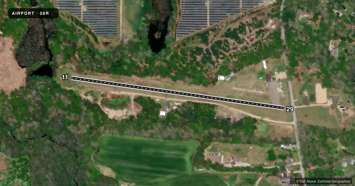
Airport sketch
Runways drawn to scale from FAA survey coordinates, rendered over satellite imagery. Not for navigation.
Approaches & charts
Services on the field
Fuel grades, oxygen, maintenance, ramp storage and lighting — as declared to the FAA by the airport operator.
Fuel & services
- Fuel
- 100LL
- Airframe repair
- Major
- Power plant repair
- Major
- Other services
- INSTR,SALES
Ramp & ground
- Transient storage
- Tie-down
- Hangar
- Landing fee
- No fee published
- Lighting schedule
- SEE RMK
- Wind indicator
- Lighted
- Segmented circle
- No
Fuel & FBOs
Cheapest 100LL and Jet A on the field and nearby. Always confirm with the FBO before taxi.
Airport notes
Surface conditions, obstructions, local procedures, lighting outages and other notes published with each FAA cycle.
General notes
- ULTRALIGHTS ON & INVOF ARPT.
- DEER & BIRDS ON & INVOF ARPT.
- RWY 11 CLSD NGTS.
- +40 FT DROPOFF, 150 FT FM RWY 29 END; +10 FT DROPOFF, 200 FT FM RWY 11 END.
- IREG HRS OF OPN. CALL 401 783-1498 FOR ACFT RQRG FUEL.
- FOR CD CTC PROVIDENCE APCH AT 401-738-8945, WHEN APCH CLSD CTC BOSTON ARTCC AT 603-879-6859.
- RWY HAS NON-STD SAFETY AREA, CTC AMGR FOR DTLS.
Lighting notes
- ROTG BCN OTS INDEFLY.
- ACTVT LIRL RWY 11/29; WINDSOCK LGTS - CTAF.
Runway surface & condition
- 11/29NSTD LIRL LCTD 30 FT FM EDGE OF PAVEMENT.
Approach & departure obstructions
- 11RWY 11, +23 FT TREES 150 FT FM THLD, 50 FT LEFT; +27 FT TREES 160 FT FM THLD, 110 FT RIGHT.
- 29RWY 29, 11 FT WIDE ROAD 90 FT FM THLD, ON CNTRLN; +40 FT TREES 125 FT FM THLD, 110 FT LEFT; +65 FT TREES 200 FT FM THLD, 45 FT RIGHT.
- 29DSPLCD THR LGTD & MKD WITH WHITE BAR & NR.
- 29APCH RATIO 5:1 TO DSPLCD THR.
Other notes
- THIS AIRPORT HAS BEEN SURVEYED BY THE NATIONAL GEODETIC SURVEY.
- VFR USE ONLY. HEL ASP: FILED FOR RECORD PURPOSES ONLY.
VFR map & nearby airports
VFR sectional. Tap any ICAO chip to open that airport.
Key facts · 08R
Answer card- ICAO
- 08R
- Name
- RICHMOND
- Location
- WEST KINGSTON, RHODE ISLAND
- Elevation
- 130.4 ft MSL
- Traffic pattern altitude
- 1,130.4 ft MSL (1,000 AGL)
- Control tower
- Non-towered (use CTAF)
- Total runways
- 1
- Longest runway
- 11/29 · 2,129 ft
- Published ILS approaches
- 0
- Published frequencies
- 2
- Magnetic variation
- 15°
- Current flight rules
- VFR
- Current wind
- 000° at 0 kt
- Favored runway now
- –
Richmond Airport sits in West Kingston, Rhode Island. The field elevation is 130.4 ft MSL. It has one runway, 11/29, which is 2,129 ft long. There is no control tower. No ILS approaches are published here. The pattern altitude is not published, so use the standard 1,000 ft AGL for light piston traffic unless the current Chart Supplement says otherwise.
Richmond Airport is a small field with one on-field FBO. Richmond Airport carries AVGAS 100LL. Call (401) 783-1498 before you go if you need fuel, since the airport has irregular hours. The published remarks also note that the rotating beacon is out of service indefinitely. Runway 11 uses low-intensity lights. The windsock lights are controlled by CTAF. Runway 11 is closed at night.
Plan for local hazards on arrival. Deer and birds are reported on and near the airport. There are dropoffs beyond both runway ends. Runway 11 also has trees close in on the approach side. The field is non-towered, so use CTAF 122.8 for traffic and listen for ultralights in the area. For clearance delivery, contact Providence Approach. If approach is closed, contact Boston ARTCC. Check the current FAA Chart Supplement before flying in for any updated lighting, runway, or operational notes.