METAR & TAF KUUU
Current METAR
Observed 15:53Z
KUUU 251553Z AUTO 10010KT 10SM CLR 24/11 A3013 RMK AO2 SLP202 T02440106 TSNO
- Wind
- 100° @ 10 kt
- Visibility
- 10 SM
- Temp / Dew
- 24°C / 11°C
- Altimeter
- 30.13 inHg
- Clouds
- CLR
- Density alt
- 1,033 ft
- Ceiling
- Unlimited
- Rules
- VFR
Airport info & contacts
Manager on record, flight service, ARTCC, attendance schedule and pattern altitude — published by the FAA and refreshed every 28 days.
Location
- From city
- 2 NM NE
- VFR sectional
- NEW YORK
- ARTCC
- ZBW · BOSTON
- NOTAM facility
- UUU (NOTAM-D)
Airport manager
- Name
- IFTIKHAR AHMAD
- Phone
- 401-691-2000
- Address
- RHODE ISLAND AIRPORT CORP, 2000 POST RD, WARWICK RI 02886
Flight service · Hours
- FSS BDR
- BRIDGEPORT1-800-WX-BRIEF
- Attendance
- MAY-SEP · SUN-SAT · 0800-1800
- OCT-APR · SUN-SAT · 0800-1600
Frequencies
Tap any row to copy the frequency to your clipboard.
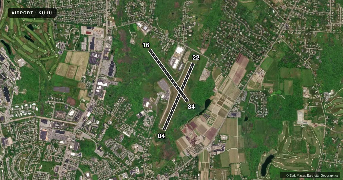
Runways & pattern
Full pagePattern entry · RWY 16
LEFT TRAFFIC| Runway | Heading (°M) | Length | Surface | Traffic |
|---|---|---|---|---|
| 04/22 | 9° / 189° | 2,999 ft | ASPH | Standard L |
| 16/34Favored | 129° / 309° | 2,623 ft | ASPH | Standard L |
Runway end performance
| End | TORA | TODA | ASDA | LDA | VGSI | Approach lights | Obstruction |
|---|---|---|---|---|---|---|---|
| 04 | — | — | — | — | VASI 4-box left(4°) | — | 75', trees, 1250' from thr, 20' R of cntrln, slope 14 |
| 22 | — | — | — | — | PAPI 4-box left(4°) | — | 38', trees, 750' from thr, 250' R of cntrln, slope 14 |
| 16 | — | — | — | — | VASI 4-box left(3.75°) | — | 37', trees, 525' from thr, 250' R of cntrln, slope 8 |
| 34 | — | — | — | — | — | — | 37', trees, 900' from thr, 200' R of cntrln, slope 18 |
Declared distances in feet. TORA = takeoff run available, TODA = takeoff distance, ASDA = accelerate-stop, LDA = landing distance.
Airport sketch
Runways drawn to scale from FAA survey coordinates, rendered over satellite imagery. Not for navigation.
Approaches & charts
ILS · 1
Services on the field
Fuel grades, oxygen, maintenance, ramp storage and lighting — as declared to the FAA by the airport operator.
Fuel & services
- Fuel
- 100LLA
- Oxygen (bottled)
- Not available
- Oxygen (bulk)
- Not available
- Airframe repair
- Major
- Power plant repair
- Major
- Other services
- CHTR,INSTR,PAJA,RNTL,SALES
Ramp & ground
- Transient storage
- Tie-down
- Hangar
- Landing fee
- Yes
- Customs
- Not available
- Lighting schedule
- SEE RMK
- Beacon schedule
- SS-SR
- Beacon
- White / Green (civil land)(WG)
- Wind indicator
- Lighted
- Segmented circle
- Yes
Fuel & FBOs
Cheapest 100LL and Jet A on the field and nearby. Always confirm with the FBO before taxi.
Airport notes
Surface conditions, obstructions, local procedures, lighting outages and other notes published with each FAA cycle.
General notes
- PPR FOR JET ACFT.
- DEER & BIRDS ON & INVOF ARPT.
- RWY CONDS MAY NOT BE MNT OR RPRTD WHEN ARPT IS UNATNDD. ARPT UNATNDD 1800-0700 DLY & SUN-MON. CTC RIAC OPS AT 401-691-2265.
- ARPT LCTD IN NOISE SENSITIVE AREA. POPULATED AREAS TO THE N, S, & E. NOISE ABATEMENT PROCS IN EFCT. CTC AMGR 401-691-2265 FOR MORE INFO.
- HELS REQSTD TO AVOID MAIN TRML RAMP FOR PRKG OR LDG. PLS CTC AMGR.
- SEASONAL BIRD ACTVTY AER 34, CTC AMGR FOR DTLS 401-691-2265.
- 24 HRS ADVN NOTICE RQRD FOR ALL JET A SVCS AFT POSTED BUS HRS.
- FOR CD WHEN APCH CLSD CTC BOSTON ARTCC AT 603-879-6859.
- NMRS UNLGTD OBSTNS UP TO 150 FT AGL SRNDG AIRFIELD.
- RWY 04 DSGND CALM WIND RWY.
Lighting notes
- ACTVT REIL RWY 22; PAPI RWY 22, VASI RWY 4 & 16; MIRL RWY 04/22 & 16/34; TWY A, B, C & RAMP AREA - CTAF.
Fuel notes
- 100LLFUEL AVBL 24 HRS BY CREDIT CARD.
Approach & departure obstructions
- 0410 FT TREES, 160 FT FM THR, 120 FT R; 20 FT TREES, 100 FT FM THR, 200 FT L.
- 1610 FT FENCE/TREES 50 FT FM THR, 220 FT L; 10 FT TREES, 190 FT FM THR, 240 FT R.
- 04TMPRY DTHR 499 FT.
- 04OTS UFN.
- 0422:1 FM TMPRY DTHR.
- 3429:1 FM DTHR.
Other notes
- OVNGT PRKG FEE. LDG FEE COML & NON RHODE ISLAND REG ACFT.
- 16/34NMRS CRACKS FULL WID & LEN.
VFR map & nearby airports
VFR sectional. Tap any ICAO chip to open that airport.
Key facts · KUUU
Answer card- ICAO
- KUUU
- Name
- NEWPORT STATE
- Location
- NEWPORT, RHODE ISLAND
- Elevation
- 171.8 ft MSL
- Traffic pattern altitude
- 1,171.8 ft MSL (1,000 AGL)
- Control tower
- Non-towered (use CTAF)
- Total runways
- 2
- Longest runway
- 04/22 · 2,999 ft
- Published ILS approaches
- 1
- Published frequencies
- 5
- Magnetic variation
- 15°
- Current flight rules
- VFR
- Current wind
- 100° at 10 kt
- Favored runway now
- RWY 16
Newport State Airport (KUUU) sits in Newport, Rhode Island. Field elevation is 171.8 ft MSL. The airport has 2 asphalt runways. The longest is 2,999 ft on runway 04/22. There is no control tower. CTAF and UNICOM are both 123.05. Approach and departure service is handled by Providence on 128.7 and 269.525. Runway 22 has the ILS. Pattern altitude is not published. Use 1,000 ft AGL for light piston traffic unless the current Chart Supplement says otherwise.
FlightLevel Aviation is on the field. It carries 100LL, Jet A and Jet A Prist. Fuel is available 24 hours by credit card. The airport is in a noise sensitive area. Populated areas sit to the north, south and east. Noise abatement procedures are in effect. Call the airport manager if you need the current guidance. The field is unattended daily from 1800 to 0700. It is also unattended on Sunday and Monday. Runway 04 has a temporary displaced threshold of 499 ft. There are trees near the threshold on runway 04. Runway 16 has trees and a fence near the threshold. Runway 16/34 also has numerous cracks full width and length. For a first visit, plan for short-field performance. Watch the displaced threshold on 04. Brief the noise procedures before arrival.