METAR & TAF 1M8
1M8 does not publish a METAR.
Showing the nearest reporting station: KTAN (TAUNTON MUNI/KING FLD) · 2.2 NM away. Conditions at 1M8 may differ.
METAR · KTAN
Observed 10:52Z
KTAN 271052Z AUTO 00000KT 10SM BKN095 13/13 A2985 RMK AO2 SLP108 T01280128
- Wind
- 000° @ 0 kt
- Visibility
- 10 SM
- Temp / Dew
- 13°C / 13°C
- Altimeter
- 29.85 inHg
- Clouds
- BKN
- Density alt
- -63 ft
- Ceiling
- 9,500 ft AGL
- Rules
- VFR
Airport info & contacts
Manager on record, flight service, ARTCC, attendance schedule and pattern altitude — published by the FAA and refreshed every 28 days.
Location
- From city
- 3 NM SE
- VFR sectional
- NEW YORK
- ARTCC
- ZBW · BOSTON
- NOTAM facility
- BDR (NOTAM-D)
Airport manager
- Name
- JEAN HARLEY
- Phone
- 508-822-2457
- Address
- 168 PADELFORD ST, BERKLEY MA 02779
Flight service · Hours
- FSS BDR
- BRIDGEPORT1-800-WX-BRIEF
- Attendance
- DALGT
Frequencies
Tap any row to copy the frequency to your clipboard.
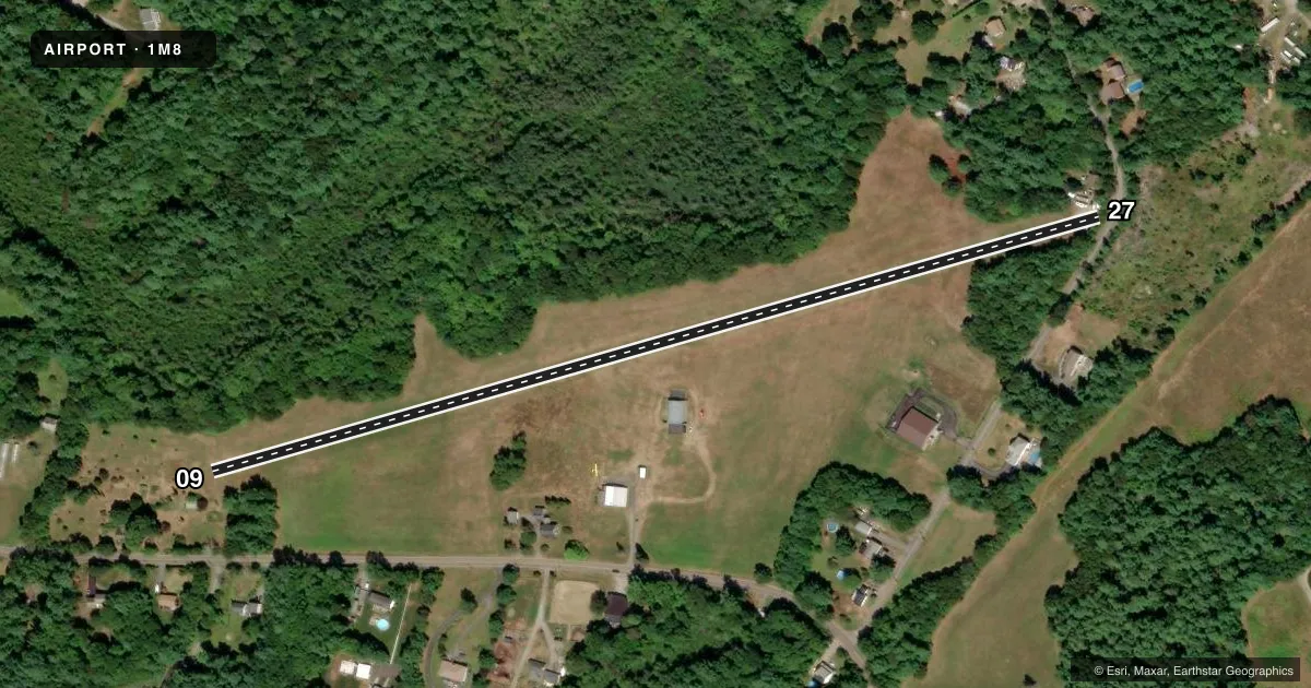
Runways & pattern
Full pagePattern entry · RWY 09
LEFT TRAFFICRunway end performance
| End | TORA | TODA | ASDA | LDA | VGSI | Approach lights | Obstruction |
|---|---|---|---|---|---|---|---|
| 09 | — | — | — | — | — | — | 80', tree, 400' from thr, 130' R of cntrln, slope 5 |
| 27 | — | — | — | — | — | — | 70', trees, 200' from thr, 125' R of cntrln, slope 2 |
Declared distances in feet. TORA = takeoff run available, TODA = takeoff distance, ASDA = accelerate-stop, LDA = landing distance.
Airport sketch
Runways drawn to scale from FAA survey coordinates, rendered over satellite imagery. Not for navigation.
Approaches & charts
Services on the field
Fuel grades, oxygen, maintenance, ramp storage and lighting — as declared to the FAA by the airport operator.
Fuel & services
- Fuel
- 100LL
- Airframe repair
- Minor
- Power plant repair
- Minor
Ramp & ground
- Transient storage
- Tie-down
- Landing fee
- No fee published
- Customs
- Not available
- Wind indicator
- Yes
- Segmented circle
- No
Fuel & FBOs
Cheapest 100LL and Jet A on the field and nearby. Always confirm with the FBO before taxi.
Airport notes
Surface conditions, obstructions, local procedures, lighting outages and other notes published with each FAA cycle.
General notes
- TREES NORTH.
- AERIAL BANNER PICKUP & DROP OPNS ON & INVOF ARPT.
- WILDLIFE ON & INVOF ARPT.
- FOR CD CTC PROVIDENCE APCH AT 401-738-8945, WHEN APCH CLSD CTC BOSTON ARTCC AT 603-879-6859.
Other notes
- THIS AIRPORT HAS BEEN SURVEYED BY THE NATIONAL GEODETIC SURVEY.
- PRVD ALL APCHS ARE CLEAR OF OBSTRUCTIONS; VFR OPS ONLY; NO TOUCH & GO OPS; FURTHER LIMITATIONS ON THIS PUBLIC-USE STATUS MAY BE IMPOSED IF FUTURE OPS INTERFERE WITH TAUNTON MUNI ARPT.
- MANAGERJEAN.HARLEY@COMCAST.NET
VFR map & nearby airports
VFR sectional. Tap any ICAO chip to open that airport.
Key facts · 1M8
Answer card- ICAO
- 1M8
- Name
- MYRICKS
- Location
- BERKLEY, MASSACHUSETTS
- Elevation
- 73 ft MSL
- Traffic pattern altitude
- 1,073 ft MSL (1,000 AGL)
- Control tower
- Non-towered (use CTAF)
- Total runways
- 1
- Longest runway
- 09/27 · 2,466 ft
- Published ILS approaches
- 0
- Published frequencies
- 1
- Magnetic variation
- 16°
- Current flight rules
- VFR
- Current wind
- 000° at 0 kt
- Favored runway now
- –
Myricks Airport sits in Berkley, Massachusetts. Field elevation is 73 ft MSL. The airport has one runway. Runway 09/27 is 2,466 ft long and is turf. No tower is published here, so plan on self-announce traffic on CTAF 122.9. No ILS approaches are published. The field is used for VFR operations only. The published remarks also say no touch-and-go operations are allowed. That matters if you are planning pattern work or training flights.
Pattern altitude is not published. Use the standard 1,000 ft AGL for light piston operations unless the current Chart Supplement says otherwise. Trees are located north of the field. Wildlife is also reported on and near the airport. That makes a careful low approach and a good runway check worthwhile, especially after weather changes or at dawn and dusk. Aerial banner pickup and drop operations also occur here, so expect some nonstandard activity in the area. There are no on-field FBOs listed. If you need fuel or local services, contact the airport operator directly before you go. For clearance delivery, the published contact is Providence Approach. When approach is closed, the remarks direct pilots to Boston ARTCC. Check the current Chart Supplement before flying in if you need the latest operating limits or any local restrictions.