METAR & TAF 1B9
Current METAR
Observed 11:35Z
K1B9 271135Z AUTO 00000KT 10SM OVC100 15/12 A2984 RMK AO2 T01490120 $
- Wind
- 000° @ 0 kt
- Visibility
- 10 SM
- Temp / Dew
- 15°C / 12°C
- Altimeter
- 29.84 inHg
- Clouds
- OVC
- Density alt
- 252 ft
- Ceiling
- 10,000 ft AGL
- Rules
- VFR
Airport info & contacts
Manager on record, flight service, ARTCC, attendance schedule and pattern altitude — published by the FAA and refreshed every 28 days.
Location
- From city
- 2 NM SE
- VFR sectional
- NEW YORK
- ARTCC
- ZBW · BOSTON
- NOTAM facility
- BDR (NOTAM-D)
Airport manager
- Name
- KEVIN BULLOCK
- Phone
- 508-930-1121
- Address
- 265 FRUIT ST, MANSFIELD MA 02048
Flight service · Hours
- FSS BDR
- BRIDGEPORT1-800-WX-BRIEF
- Attendance
- APR-NOV · 0800-DUSK
- DEC-MAR · 0900-1700
Frequencies
Tap any row to copy the frequency to your clipboard.
Runways & pattern
Full pagePattern entry · RWY 14
LEFT TRAFFIC| Runway | Heading (°M) | Length | Surface | Traffic |
|---|---|---|---|---|
| 14/32 | 107° / 287° | 3,500 ft | ASPH | Standard L |
| 04/22 | 12° / 192° | 2,059 ft | TURF | Standard L |
Runway end performance
| End | TORA | TODA | ASDA | LDA | VGSI | Approach lights | Obstruction |
|---|---|---|---|---|---|---|---|
| 14 | — | — | — | — | — | — | 50', trees, 1200' from thr, slope 20 |
| 32 | — | — | — | — | PAPI 4-box left(4°) | — | 50', trees, 800' from thr, 125' R of cntrln, slope 12 |
| 04 | — | — | — | — | — | — | 42', trees, 830' from thr, slope 20 |
| 22 | — | — | — | — | — | — | 100', trees, 600' from thr, 40' R of cntrln, slope 6 |
Declared distances in feet. TORA = takeoff run available, TODA = takeoff distance, ASDA = accelerate-stop, LDA = landing distance.
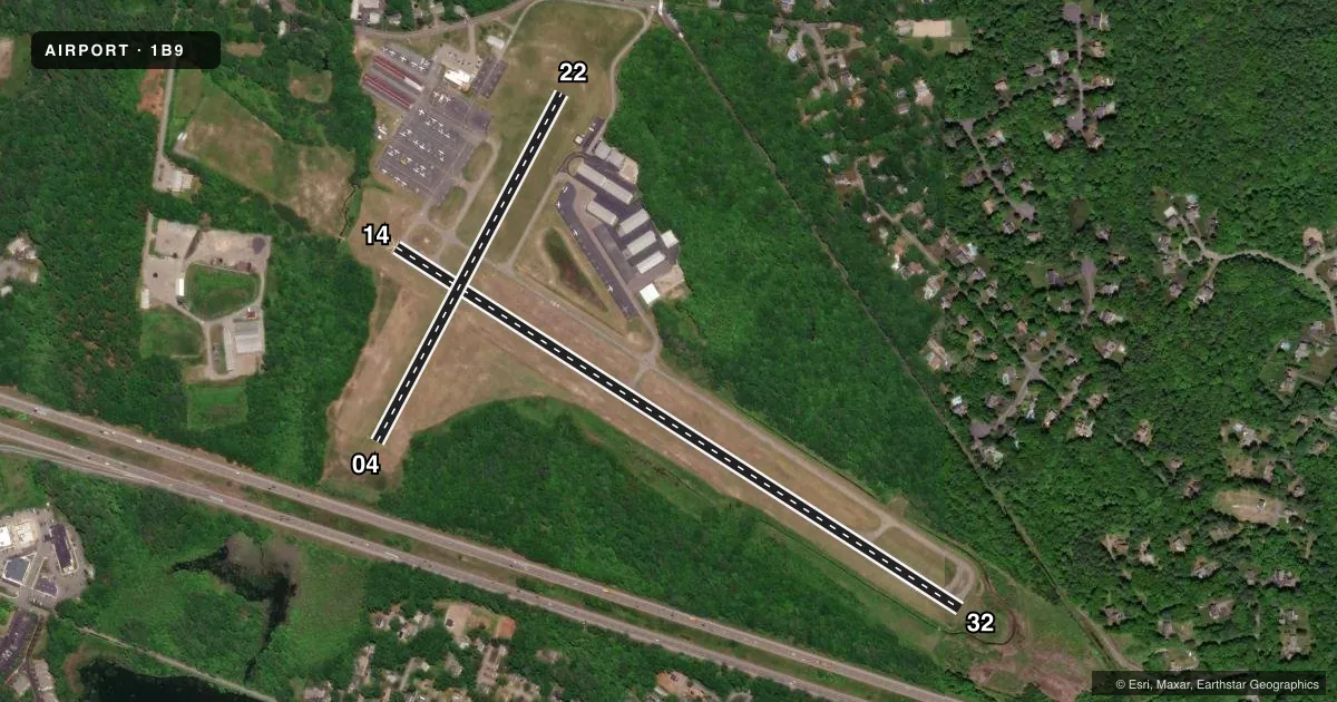
Airport sketch
Runways drawn to scale from FAA survey coordinates, rendered over satellite imagery. Not for navigation.
Approaches & charts
Services on the field
Fuel grades, oxygen, maintenance, ramp storage and lighting — as declared to the FAA by the airport operator.
Fuel & services
- Fuel
- 100LL
- Oxygen (bottled)
- Not available
- Oxygen (bulk)
- Not available
- Airframe repair
- Major
- Power plant repair
- Major
- Other services
- AMB,CHTR,INSTR
Ramp & ground
- Transient storage
- Tie-down
- Landing fee
- No fee published
- Customs
- Not available
- Lighting schedule
- SEE RMK
- Beacon schedule
- SS-SR
- Beacon
- White / Green (civil land)(WG)
- Wind indicator
- Yes
- Segmented circle
- No
Fuel & FBOs
Cheapest 100LL and Jet A on the field and nearby. Always confirm with the FBO before taxi.
Airport notes
Surface conditions, obstructions, local procedures, lighting outages and other notes published with each FAA cycle.
General notes
- TURF STRIP CLSD WINTER MONTHS & AFT HVY RAINS.
- ON DEP RWY 32 TURN L TO 290 DEGS.
- ON DEP RWY 14 NO L TURNS TIL 824 FT MSL.
- NO TGLS 2100-0800.
- NO R TURNS ON DEP FM RWY 32 TIL 1000 FT MSL.
- FOR CD CTC BOSTON APCH AT 603-594-5554.
- WILDLIFE ON & INVOF ARPT.
- RWY 14/32 LGTS OTS.
Lighting notes
- ROTG BCN OTS.
- ACTVT PAPI RWY 32; MIRL RWY 14/32 - CTAF.
Approach & departure obstructions
- 14APCH RATIO 34:1 TO DTHR.
- 32APCH RATIO 34:1 TO DTHR.
Other notes
- ESTAB PRIOR 1959.
- MANAGEROR 508-339-3001.
VFR map & nearby airports
VFR sectional. Tap any ICAO chip to open that airport.
Key facts · 1B9
Answer card- ICAO
- 1B9
- Name
- MANSFIELD MUNI
- Location
- MANSFIELD, MASSACHUSETTS
- Elevation
- 122.9 ft MSL
- Traffic pattern altitude
- 1,122.9 ft MSL (1,000 AGL)
- Control tower
- Non-towered (use CTAF)
- Total runways
- 2
- Longest runway
- 14/32 · 3,500 ft
- Published ILS approaches
- 0
- Published frequencies
- 4
- Magnetic variation
- 16°
- Current flight rules
- VFR
- Current wind
- 000° at 0 kt
- Favored runway now
- –
Mansfield Muni sits in Mansfield, Massachusetts at 122.9 ft MSL. It has two runways. The longest is 14/32 at 3,500 ft. Runway 04/22 is turf and 2,059 ft. The field is non-towered. CTAF and UNICOM are both 123.0. Boston Approach handles approach and departure services on 124.1 and 343.6.
No ILS approaches are published here. Pattern altitude is not published, so plan on the standard 1,000 ft AGL for light piston traffic unless the current FAA Chart Supplement says otherwise. The airport has two on-field fuel providers. Raven Energy carries Jet A. Aero Fuel Management carries 100LL. Check with the FBO directly for current availability before you go.
A few local items matter on the first visit. The turf runway closes in winter months and after heavy rain. Wildlife is reported on and near the airport. Runway 14 departures have a no-left-turn restriction until 824 ft MSL. Runway 32 departures call for a left turn to 290 degrees. Night touch-and-go work is not allowed between 2100 and 0800. Runway 14/32 lights and the rotating beacon are out of service, so plan accordingly and verify current lighting status before a night arrival.