METAR & TAF KPYM
Current METAR
Observed 09:13Z
KPYM 270913Z AUTO 31003KT 10SM BKN004 OVC085 15/15 A2982 RMK AO2 T01500150 $
- Wind
- 310° @ 3 kt
- Visibility
- 10 SM
- Temp / Dew
- 15°C / 15°C
- Altimeter
- 29.82 inHg
- Clouds
- OVC
- Density alt
- 308 ft
- Ceiling
- 400 ft AGL
- Rules
- LIFR
Airport info & contacts
Manager on record, flight service, ARTCC, attendance schedule and pattern altitude — published by the FAA and refreshed every 28 days.
Location
- From city
- 4 NM SW
- VFR sectional
- NEW YORK
- ARTCC
- ZBW · BOSTON
- NOTAM facility
- PYM (NOTAM-D)
Airport manager
- Name
- MATTHEW CARDILLO
- Phone
- 508-746-2020
- Address
- 246 SOUTH MEADOW RD, PLYMOUTH MA 02360
Flight service · Hours
- FSS BDR
- BRIDGEPORT1-800-WX-BRIEF
- Attendance
- 0600-2200
Frequencies
Tap any row to copy the frequency to your clipboard.
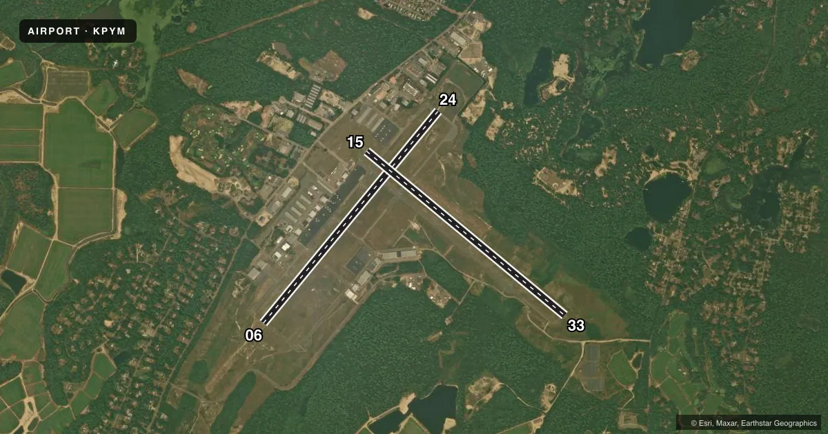
Runways & pattern
Full pagePattern entry · RWY 33
LEFT TRAFFIC| Runway | Heading (°M) | Length | Surface | Traffic |
|---|---|---|---|---|
| 06/24 | 24° / 204° | 4,650 ft | ASPH | Standard L |
| 15/33Favored | 114° / 294° | 4,350 ft | ASPH | Standard L |
Runway end performance
| End | TORA | TODA | ASDA | LDA | VGSI | Approach lights | Obstruction |
|---|---|---|---|---|---|---|---|
| 06 | — | — | — | — | PAPI 4-box left(3°) | MALSF | 35', trees, 1700' from thr, 0' R of cntrln, slope 50 |
| 24 | — | — | — | — | PAPI 4-box left(4°) | — | 65', trees, 1500' from thr, 0' R of cntrln, slope 20 |
| 15 | 4,350' | 4,350' | 4,350' | 4,350' | — | — | 27', trees, 750' from thr, 125' R of cntrln, slope 20 |
| 33 | 4,350' | 4,350' | 4,650' | 4,350' | PAPI 4-box left(3°) | — | 80', tree, 1800' from thr, 125' R of cntrln, slope 20 |
Declared distances in feet. TORA = takeoff run available, TODA = takeoff distance, ASDA = accelerate-stop, LDA = landing distance.
Airport sketch
Runways drawn to scale from FAA survey coordinates, rendered over satellite imagery. Not for navigation.
Approaches & charts
ILS · 1
Services on the field
Fuel grades, oxygen, maintenance, ramp storage and lighting — as declared to the FAA by the airport operator.
Fuel & services
- Fuel
- 100LLA
- Oxygen (bottled)
- Low pressure
- Oxygen (bulk)
- Low pressure
- Airframe repair
- Major
- Power plant repair
- Major
- Other services
- AFRT,AGRI,AMB,AVNCS,CHTR,INSTR,RNTL,SALES
Ramp & ground
- Transient storage
- Tie-down
- Hangar
- Landing fee
- No fee published
- Customs
- Not available
- Lighting schedule
- SEE RMK
- Beacon schedule
- SS-SR
- Beacon
- White / Green (civil land)(WG)
- Wind indicator
- Yes
- Segmented circle
- Yes
Fuel & FBOs
Cheapest 100LL and Jet A on the field and nearby. Always confirm with the FBO before taxi.
Airport notes
Surface conditions, obstructions, local procedures, lighting outages and other notes published with each FAA cycle.
General notes
- FOR CD CTC BOSTON APCH AT 603-594-5554.
- NO TGLS 2100-0800 LCL.
- BE AWARE OF HIGH SPD MIL JET AND HVY HEL TFC INVOF CAPE COD CGAS.
- WILDLIFE ON AND INVOF AIRPORT.
- DEPG ACFT ENCOURAGED TO FLY LCL NOISE ABATEMENT PROCS.
- RWY 33 CALM WIND RWY.
Lighting notes
- ACTVT MALSF RWY 06; REIL RWY 24; PAPI RWY 06, 24 & 33; MIRL RWY 06/24 & 15/33 - 122.9.
Other notes
- ESTAB PRIOR TO 1959.
- MANAGERTMAHER@TOWNHALL.PLYMOUTH.MA.US.
VFR map & nearby airports
VFR sectional. Tap any ICAO chip to open that airport.
Key facts · KPYM
Answer card- ICAO
- KPYM
- Name
- PLYMOUTH MUNI
- Location
- PLYMOUTH, MASSACHUSETTS
- Elevation
- 148.1 ft MSL
- Traffic pattern altitude
- 1,148.1 ft MSL (1,000 AGL)
- Control tower
- Non-towered (use CTAF)
- Total runways
- 2
- Longest runway
- 06/24 · 4,650 ft
- Published ILS approaches
- 1
- Published frequencies
- 5
- Magnetic variation
- 16°
- Current flight rules
- LIFR
- Current wind
- 310° at 3 kt
- Favored runway now
- RWY 33
Plymouth Muni is in Plymouth, Massachusetts. The field elevation is 148.1 ft MSL. It has two asphalt runways. The longest is runway 06/24 at 4,650 ft. There is no control tower, so plan to use CTAF and standard non-towered procedures.
The airport has one ILS approach to runway 06. Published lighting includes an activated MALSR on 06, REIL on 24, PAPI on 06, 24 and 33. It also has MIRL on both runways. Pattern altitude is not published in the facts, so verify the current Chart Supplement before you fly. Runway 33 is listed as the calm wind runway. Wildlife is reported on and near the airport. Keep a sharp scan on taxi, takeoff and landing.
Plymouth Municipal Airport is the on-field FBO. It carries 100LL, Jet A and Jet A Prist. For clearance delivery, Boston Approach is listed in the remarks. Pilots should also note the published noise abatement procedures. There is a no touch-and-go restriction between 2100 and 0800 local time. Traffic in the area can include high speed military jets and heavy helicopters near Cape Cod Coast Guard Air Station. Keep your situational awareness up on departure and arrival.