METAR & TAF 2B1
2B1 does not publish a METAR.
Showing the nearest reporting station: KHYA (CAPE COD GATEWAY) · 5.5 NM away. Conditions at 2B1 may differ.
METAR · KHYA
Observed 01:56Z
KHYA 270156Z 04008KT 10SM OVC003 18/18 A2984 RMK AO2 SLP106 T01830178
- Wind
- 040° @ 8 kt
- Visibility
- 10 SM
- Temp / Dew
- 18°C / 18°C
- Altimeter
- 29.84 inHg
- Clouds
- OVC
- Density alt
- 587 ft
- Ceiling
- 300 ft AGL
- Rules
- LIFR
Airport info & contacts
Manager on record, flight service, ARTCC, attendance schedule and pattern altitude — published by the FAA and refreshed every 28 days.
Location
- From city
- 5 NM SE
- VFR sectional
- NEW YORK
- Pattern altitude
- 700 ft AGL · 803 ft MSL
- ARTCC
- ZBW · BOSTON
- NOTAM facility
- BDR (NOTAM-D)
Airport manager
- Name
- CHRISTOPHER SIDERWICZ
- Phone
- 508-428-8732
- Address
- 1000 RACE LANE, MARSTONS MILLS MA 02648
Flight service · Hours
- FSS BDR
- BRIDGEPORT1-800-WX-BRIEF
- Attendance
- DALGT
Frequencies
Tap any row to copy the frequency to your clipboard.
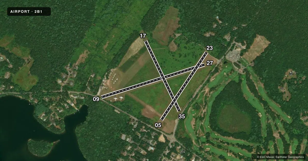
Runways & pattern
Full pagePattern entry · RWY 05
LEFT TRAFFIC| Runway | Heading (°M) | Length | Surface | Traffic |
|---|---|---|---|---|
| 09/27 | 56° / 236° | 2,700 ft | TURF | Standard L |
| 17/35 | 138° / 318° | 2,060 ft | TURF | Standard L |
| 05/23Favored | 18° / 198° | 2,035 ft | TURF | Standard L |
Runway end performance
| End | TORA | TODA | ASDA | LDA | VGSI | Approach lights | Obstruction |
|---|---|---|---|---|---|---|---|
| 09 | — | — | — | — | — | — | 5', trees, 24' from thr, 75' R of cntrln, slope 5 |
| 27 | — | — | — | — | — | — | 30', trees, 148' from thr, 60' R of cntrln, slope 5 |
| 17 | — | — | — | — | — | — | 18', trees, 72' from thr, 60' R of cntrln, slope 4 |
| 35 | — | — | — | — | — | — | 9', pline, 36' from thr, 75' R of cntrln, slope 4 |
| 05 | — | — | — | — | — | — | 13', trees, 40' from thr, 125' R of cntrln, slope 3 |
| 23 | — | — | — | — | — | — | 50', trees, 200' from thr, 125' R of cntrln, slope 4 |
Declared distances in feet. TORA = takeoff run available, TODA = takeoff distance, ASDA = accelerate-stop, LDA = landing distance.
Airport sketch
Runways drawn to scale from FAA survey coordinates, rendered over satellite imagery. Not for navigation.
Approaches & charts
Services on the field
Fuel grades, oxygen, maintenance, ramp storage and lighting — as declared to the FAA by the airport operator.
Fuel & services
- Fuel
- 100LL
- Airframe repair
- Minor
- Power plant repair
- Minor
- Other services
- GLD,TOW
Ramp & ground
- Transient storage
- Tie-down
- Hangar
- Landing fee
- No fee published
- Customs
- Not available
- Wind indicator
- Yes
- Segmented circle
- No
Fuel & FBOs
Cheapest 100LL and Jet A on the field and nearby. Always confirm with the FBO before taxi.
Airport notes
Surface conditions, obstructions, local procedures, lighting outages and other notes published with each FAA cycle.
General notes
- BE AWARE OF HIGH-SPD MIL JET & HVY HEL TFC VCNTY CAPE COD CGAS.
- BE ALERT FOR RADIO CTL AIRPLANES NE CORNER AIRFIELD.
- BANNER TOW OPNS IN PROG JUN THRU AUG, NORTH SIDE OF AIRFIELD.
- GLDR TOW OPNS DRG DALGT HRS.
- PPR FOR RWY 05/23 OPNS.
- PAJA ON FIELD.
- HEL OPNS CTC AMGR FOR ARPT PROCS/PRKG.
- FOR CD CTC BOSTON APCH AT 603-594-5554.
Approach & departure obstructions
- 35AND TREES.
Other notes
- THIS AIRPORT HAS BEEN SURVEYED BY THE NATIONAL GEODETIC SURVEY.
- ESTAB PRIOR TO 1959.
VFR map & nearby airports
VFR sectional. Tap any ICAO chip to open that airport.
Key facts · 2B1
Answer card- ICAO
- 2B1
- Name
- CAPE COD
- Location
- MARSTON MILLS, MASSACHUSETTS
- Elevation
- 103 ft MSL
- Traffic pattern altitude
- 803 ft MSL (700 AGL)
- Control tower
- Non-towered (use CTAF)
- Total runways
- 3
- Longest runway
- 09/27 · 2,700 ft
- Published ILS approaches
- 0
- Published frequencies
- 2
- Magnetic variation
- 16°
- Current flight rules
- LIFR
- Current wind
- 040° at 8 kt
- Favored runway now
- RWY 05
Cape Cod Airport sits in Marston Mills, Massachusetts. The field elevation is 103 ft MSL. It has three turf runways. The longest is runway 09/27 at 2,700 ft. There is no control tower. Use CTAF 122.9 and coordinate with Boston Approach on 118.2 for approach and departure work.
Pattern altitude is 700 ft AGL, which is 803 ft MSL. No ILS approaches are published here. That matters if you are planning a low-weather arrival. Check the current FAA Chart Supplement for the latest approach and airport data before you go.
There are no on-field FBOs listed in the facts. Contact the airport operator directly before arrival, or call the field on CTAF or UNICOM for current FBO availability. Published remarks call out high-speed military jet traffic and heavy helicopter traffic in the Cape Cod CGAS area. They also note prior permission is required for runway 05/23 operations. Glider tow operations run in daylight. Banner tow work can be active from June through August on the north side of the field. Watch the northeast corner for radio-controlled airplanes. Trees are noted near the departure end of runway 35. This is a busy turf field with mixed traffic. A good radio scan and a clean arrival plan matter.