METAR & TAF KPVC
Current METAR
Observed 01:56Z
KPVC 270156Z AUTO 04006KT 10SM OVC005 18/ A2987 RMK AO2 SLP114 T0178 PNO $
- Wind
- 040° @ 6 kt
- Visibility
- 10 SM
- Temp / Dew
- —
- Altimeter
- 29.87 inHg
- Clouds
- OVC
- Density alt
- —
- Ceiling
- 500 ft AGL
- Rules
- IFR
Airport info & contacts
Manager on record, flight service, ARTCC, attendance schedule and pattern altitude — published by the FAA and refreshed every 28 days.
Location
- From city
- 2 NM NW
- VFR sectional
- NEW YORK
- ARTCC
- ZBW · BOSTON
- NOTAM facility
- PVC (NOTAM-D)
Airport manager
- Name
- WILLIAM JURASCHEK
- Phone
- 508-487-0241
- Address
- PROVINCETOWN AIRPORT, PROVINCETOWN MA 02657
Flight service · Hours
- FSS BDR
- BRIDGEPORT1-800-WX-BRIEF
- Attendance
- MAY-OCT · 0600-1800
- NOV-APR · MON-SAT · 0600-1700
- NOV-APR · SUN · 0600-1700
Frequencies
Tap any row to copy the frequency to your clipboard.
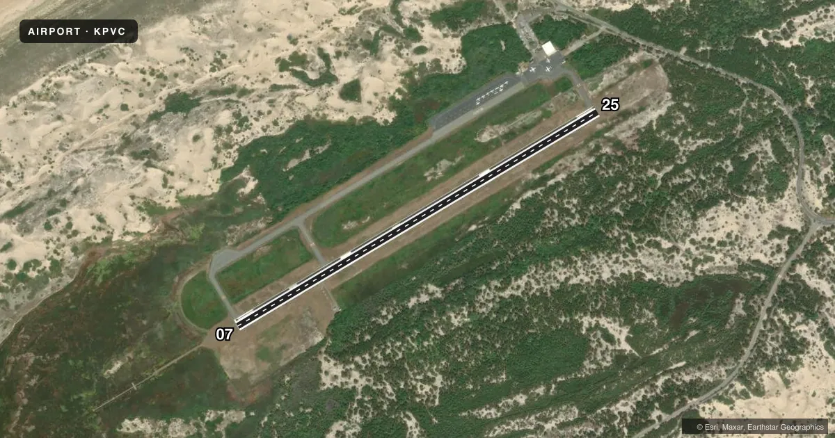
Runways & pattern
Full pagePattern entry · RWY 07
LEFT TRAFFICRunway end performance
| End | TORA | TODA | ASDA | LDA | VGSI | Approach lights | Obstruction |
|---|---|---|---|---|---|---|---|
| 07 | — | — | — | — | PAPI 4-box right(3°) | MALSF | — |
| 25 | — | — | — | — | PAPI 4-box left(3°) | — | 12', trees, 610' from thr, 125' R of cntrln, slope 34 |
Declared distances in feet. TORA = takeoff run available, TODA = takeoff distance, ASDA = accelerate-stop, LDA = landing distance.
Airport sketch
Runways drawn to scale from FAA survey coordinates, rendered over satellite imagery. Not for navigation.
Approaches & charts
ILS · 1
Services on the field
Fuel grades, oxygen, maintenance, ramp storage and lighting — as declared to the FAA by the airport operator.
Fuel & services
- Fuel
- 100LLA+
- Oxygen (bottled)
- Not available
- Oxygen (bulk)
- Not available
- Airframe repair
- Not available
- Power plant repair
- Not available
- Other services
- CHTR
Ramp & ground
- Transient storage
- Tie-down
- Landing fee
- Yes
- Customs
- Not available
- Lighting schedule
- SEE RMK
- Beacon schedule
- SS-SR
- Beacon
- White / Green (civil land)(WG)
- Wind indicator
- Yes
- Segmented circle
- Yes
Fuel & FBOs
Cheapest 100LL and Jet A on the field and nearby. Always confirm with the FBO before taxi.
Airport notes
Surface conditions, obstructions, local procedures, lighting outages and other notes published with each FAA cycle.
General notes
- WILDLIFE ON & INVOF ARPT.
- CTN: HIGH SPD MIL & HEL TFC INVOF CAPE COD CGAS.
- SAWRS.
- FOR CD CTC BOSTON APCH AT 603-594-5554.
Lighting notes
- ACTVT MALSF RWY 07; REIL RWY 25; PAPI RWY 07 & 25; HIRL RWY 07/25 - 122.85.
- ULTRALIGHT OPS NA MAY 1 - SEP 30.
Fuel notes
- 100LLFOR AVBLTY - AMGR.
Other notes
- THIS AIRPORT HAS BEEN SURVEYED BY THE NATIONAL GEODETIC SURVEY.
- ESTAB PRIOR TO 1959.
- PRKG FEE.
- CHTRPART TIME.
VFR map & nearby airports
VFR sectional. Tap any ICAO chip to open that airport.
Key facts · KPVC
Answer card- ICAO
- KPVC
- Name
- PROVINCETOWN MUNI
- Location
- PROVINCETOWN, MASSACHUSETTS
- Elevation
- 7.8 ft MSL
- Traffic pattern altitude
- 1,007.8 ft MSL (1,000 AGL)
- Control tower
- Non-towered (use CTAF)
- Total runways
- 1
- Longest runway
- 07/25 · 3,502 ft
- Published ILS approaches
- 1
- Published frequencies
- 4
- Magnetic variation
- 16°
- Current flight rules
- IFR
- Current wind
- 040° at 6 kt
- Favored runway now
- RWY 07
Provincetown Muni sits in Provincetown, Massachusetts at 7.8 ft MSL. It has one runway, 07/25, which is 3,502 ft long. There is no control tower. The field has one ILS approach on runway 07. Pattern altitude is not published in the facts, so use the current Chart Supplement before you fly. The airport is on Cape Cod near the Coast Guard Air Station. Expect high speed military and helicopter traffic in the area.
The on-field FBO is Provincetown Municipal Airport. It carries AVGAS 100LL and JET A PRIST. Call ahead at (508) 487-7038 for current service details. Published remarks also note a parking fee. For clearance delivery, contact Boston Approach at 603-594-5554. The remarks mention medium intensity approach lighting with sequenced flashers on runway 07, runway end identifier lights on runway 25, PAPI on both runway ends and high intensity runway lights on both ends. There is also a note that ultralight operations are not authorized from May 1 through September 30.
This is a coastal airport with wildlife in and around the field. Keep that in mind on taxi, takeoff and landing. If you need current noise, parking, or operational details, check the current FAA Chart Supplement or call the airport operator directly.