METAR & TAF 5B6
5B6 does not publish a METAR.
Showing the nearest reporting station: KMVY (MARTHA'S VINEYARD) · 12.0 NM away. Conditions at 5B6 may differ.
METAR · KMVY
Observed 01:53Z
KMVY 270153Z 01004KT 10SM OVC008 19/17 A2985 RMK AO2 SLP107 T01890172
- Wind
- 010° @ 4 kt
- Visibility
- 10 SM
- Temp / Dew
- 19°C / 17°C
- Altimeter
- 29.85 inHg
- Clouds
- OVC
- Density alt
- 618 ft
- Ceiling
- 800 ft AGL
- Rules
- IFR
Airport info & contacts
Manager on record, flight service, ARTCC, attendance schedule and pattern altitude — published by the FAA and refreshed every 28 days.
Location
- From city
- 4 NM NE
- VFR sectional
- NEW YORK
- ARTCC
- ZBW · BOSTON
- NOTAM facility
- BDR (NOTAM-D)
Airport manager
- Name
- JIM SCHLOTT
- Phone
- 508-548-9617
- Address
- 67 AIRPARK DR, E FALMOUTH MA 02536
Flight service · Hours
- FSS BDR
- BRIDGEPORT1-800-WX-BRIEF
- Attendance
- 0800 - 1600
Frequencies
Tap any row to copy the frequency to your clipboard.
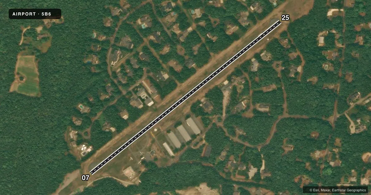
Runways & pattern
Full pagePattern entry · RWY 07
RIGHT TRAFFICRunway end performance
| End | TORA | TODA | ASDA | LDA | VGSI | Approach lights | Obstruction |
|---|---|---|---|---|---|---|---|
| 07 | — | — | — | — | — | — | 56', trees, 1014' from thr, 116' R of cntrln, slope 14 |
| 25 | — | — | — | — | — | — | 25', trees, 300' from thr, 125' R of cntrln, slope 4 |
Declared distances in feet. TORA = takeoff run available, TODA = takeoff distance, ASDA = accelerate-stop, LDA = landing distance.
Airport sketch
Runways drawn to scale from FAA survey coordinates, rendered over satellite imagery. Not for navigation.
Approaches & charts
Services on the field
Fuel grades, oxygen, maintenance, ramp storage and lighting — as declared to the FAA by the airport operator.
Fuel & services
- Fuel
- 100LLUL94
- Oxygen (bottled)
- Not available
- Oxygen (bulk)
- Not available
- Airframe repair
- Not available
- Power plant repair
- Not available
Ramp & ground
- Transient storage
- Tie-down
- Landing fee
- Yes
- Customs
- Not available
- Lighting schedule
- SEE RMK
- Beacon schedule
- SS-SR
- Beacon
- White / Green (civil land)(WG)
- Wind indicator
- Yes
- Segmented circle
- Yes
Fuel & FBOs
Cheapest 100LL and Jet A on the field and nearby. Always confirm with the FBO before taxi.
Airport notes
Surface conditions, obstructions, local procedures, lighting outages and other notes published with each FAA cycle.
General notes
- BE AWARE OF HIGH-SPD MIL JET & HVY HEL TFC INVOF CAPE COD CGAS.
- ARPT CLSD TO ACFT EXCEEDING 5000 LBS PUBLD MAX GWT.
- TURF ARND RWY 07/25 SOFT AFT RAIN.
- TSNT OPS DAYTIME ONLY. NO NGT TSNT TKOFS OR LNDGS.
- NO TSNT STUDENT ACTS, SOLO OR DUAL AT 5B6.
- FULL STOPS ONLY. TGL OPS PROHIBITED.
- WILDLIFE INVOF ARPT.
- FOR CD CTC BOSTON APCH AT 603-594-5554.
- WATCH FOR PEDESTRIANS OR ANIMALS INVOF RWY.
- ACTVT RWY LGTS WITH 5 CLICKS ON FREQ 122.7.
- NON-STD YELLOW CHEVRONS AT APCH END OF RWY 07 & 25.
- TIE DOWN ROPES AVBL IN FUEL SHED.
- SELF SVC 100LL & UL94 AVBL WITH CREDIT CARD.
- RWY 7/25 NON-STD LIRL RWY LGTS. LGTS OFFSET 40 FT N OF RWY EDGE.
- FEE FOR OVNGT PRKG.
- LDG FEE FOR COML OPS.
Lighting notes
- ACTVT LIRL RWY 07/25 - 122.7.
Other notes
- THIS AIRPORT HAS BEEN SURVEYED BY THE NATIONAL GEODETIC SURVEY.
- ESTAB PRIOR TO 1959.
VFR map & nearby airports
VFR sectional. Tap any ICAO chip to open that airport.
Key facts · 5B6
Answer card- ICAO
- 5B6
- Name
- FALMOUTH AIRPARK
- Location
- FALMOUTH, MASSACHUSETTS
- Elevation
- 41 ft MSL
- Traffic pattern altitude
- 1,041 ft MSL (1,000 AGL)
- Control tower
- Non-towered (use CTAF)
- Total runways
- 1
- Longest runway
- 07/25 · 2,298 ft
- Published ILS approaches
- 0
- Published frequencies
- 3
- Magnetic variation
- 16°
- Current flight rules
- IFR
- Current wind
- 010° at 4 kt
- Favored runway now
- RWY 07
Falmouth Airpark sits in Falmouth, Massachusetts on Cape Cod. Field elevation is 41 ft MSL. The airport has one asphalt runway, 07/25, at 2,298 ft. There is no control tower. No ILS approaches are published here.
Pattern altitude is not published. Use the standard 1,000 ft AGL pattern unless local procedures or the current Chart Supplement say otherwise. The field is a small, light-aircraft airport with a published maximum gross weight limit of 5,000 lb. Aircraft above that limit are not permitted. Full stop landings only are allowed. Touch-and-go work is prohibited.
Falmouth Airpark is the on-field FBO. It carries AVGAS 100LL and UL94. Self-serve fuel is available with a credit card. The airport also notes tie-down ropes in the fuel shed. Runway 07/25 has non-standard low intensity lights. They are activated by keying the mic on 122.7. There are yellow chevrons at the approach ends of both runway ends. Wildlife is reported in the area. Keep a sharp scan on taxi, takeoff and landing.
This is a non-towered field with Boston approach and departure on 118.2. Check the current Chart Supplement for any noise or curfew restrictions before flying in. Also verify overnight parking fees and any commercial landing fee with the airport operator or the FBO directly by phone before arrival.