METAR & TAF KHYA
Current METAR
Observed 12:56Z
KHYA 271256Z 01005KT 10SM FEW090 20/14 A2984 RMK AO2 SLP104 T02000144
- Wind
- 010° @ 5 kt
- Visibility
- 10 SM
- Temp / Dew
- 20°C / 14°C
- Altimeter
- 29.84 inHg
- Clouds
- FEW
- Density alt
- 766 ft
- Ceiling
- Unlimited
- Rules
- VFR
Airport info & contacts
Manager on record, flight service, ARTCC, attendance schedule and pattern altitude — published by the FAA and refreshed every 28 days.
Location
- From city
- 1 NM N
- VFR sectional
- NEW YORK
- ARTCC
- ZBW · BOSTON
- NOTAM facility
- HYA (NOTAM-D)
Airport manager
- Name
- MICHAEL NELSON
- Phone
- 508-775-2020
- Address
- 480 BARNSTABLE RD, HYANNIS MA 02601
Flight service · Hours
- FSS BDR
- BRIDGEPORT1-800-WX-BRIEF
- Attendance
- ALL
Frequencies
Tap any row to copy the frequency to your clipboard.
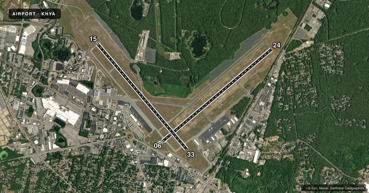
Runways & pattern
Full pagePattern entry · RWY 06
LEFT TRAFFIC| Runway | Heading (°M) | Length | Surface | Traffic |
|---|---|---|---|---|
| 06/24Favored | 34° / 214° | 5,425 ft | ASPH | Standard L |
| 15/33 | 124° / 304° | 5,255 ft | ASPH | Standard L |
Runway end performance
| End | TORA | TODA | ASDA | LDA | VGSI | Approach lights | Obstruction |
|---|---|---|---|---|---|---|---|
| 06 | 5,425' | 5,425' | 5,425' | 5,019' | PAPI 4-box left(3°) | — | 17', tree, 450' from thr, 300' R of cntrln, slope 14 |
| 24 | 5,425' | 5,425' | 5,425' | 5,425' | PAPI 4-box left(3°) | MALSF | 20', rr, 400' from thr, 300' R of cntrln, slope 10 |
| 15 | 5,255' | 5,255' | 5,255' | 5,255' | — | MALSR | 146', pline, 5175' from thr, 0' R of cntrln, slope 34 |
| 33 | 5,255' | 5,255' | 5,255' | 5,105' | PAPI 4-box left(3°) | — | — |
Declared distances in feet. TORA = takeoff run available, TODA = takeoff distance, ASDA = accelerate-stop, LDA = landing distance.
Airport sketch
Runways drawn to scale from FAA survey coordinates, rendered over satellite imagery. Not for navigation.
Approaches & charts
ILS · 2
Services on the field
Fuel grades, oxygen, maintenance, ramp storage and lighting — as declared to the FAA by the airport operator.
Fuel & services
- Fuel
- 100LLA
- Oxygen (bottled)
- Not available
- Oxygen (bulk)
- Not available
- Airframe repair
- Major
- Power plant repair
- Major
- Other services
- AFRT,AVNCS,CHTR,INSTR,RNTL,SALES
Ramp & ground
- Transient storage
- Tie-down
- Hangar
- Landing fee
- No fee published
- Customs
- Not available
- Lighting schedule
- SEE RMK
- Beacon schedule
- SS-SR
- Beacon
- White / Green (civil land)(WG)
- Wind indicator
- Lighted
- Segmented circle
- Yes
Fuel & FBOs
Cheapest 100LL and Jet A on the field and nearby. Always confirm with the FBO before taxi.
Airport notes
Surface conditions, obstructions, local procedures, lighting outages and other notes published with each FAA cycle.
General notes
- ANT ON TANK 4600 FT SE ELEV 208 FT; STANDPIPE 7050 FT NORTH 236 FT; OBSTN LGTD.
- BIRDS, COYOTES ON & INVOF ARPT.
- ARPT HAS NOISE ABATEMENT CTC AMGR 508-778-7765.
- TGL OPS PROHIBITED BTN 2100-0559, PPR BY AMGR.
- ALL TSNT & GA PILOTS MUST CTC ARPT OPS ON FREQ 122.95 PRIOR TO ENG SHTDN FOR AIRFIELD ESCORT BTN 2200-0559 LCL.
- TWY B CLSD TO ACFT WITH WINGSPAN GTR THAN 118 FT. TWY B BTN TWY D & RWY 6-24 CLSD TO ACFT WITH WINGSPAN GTR THAN 78 FT.
- BE AWARE OF HIGH-SPD MIL JET & HVY HEL TFC VCNTY JOINT BASE CAPE COD. DO NOT CONFUSE JOINT BASE CAPE COD, 10NM W WITH CAPE COD GATEWAY.
- ARFF INDEX B SVCS PRVDD BTN 0600 AND 2159 LCL DLY. ARFF INDEX A SVCS PRVDD DRG OTR TIMES. FOR INDEX B SVCS BTN 2200 AND 0559 LCL, 1HR 30MIN PPR AT 508-778-7770.
Lighting notes
- ACTVT MALSR RWY 15; MALSF RWY 24; HIRL RWYS 06/24 & 15/33 - CTAF.
Runway surface & condition
- 06/24PCR VALUE: 384/F/A/X/T
- 15/33PCR VALUE: 355/F/A/X/T
Approach & departure obstructions
- 33APCH RATIO 34:1 TO DTHR.
- 06APCH RATIO 50:1 TO DTHR.
Arresting gear
- 24_EMASENGINEERING MTRLS ARST SYS (EMAS) 200 FT IN LEN BY 176 FT WID LCTD AT THE DER 24.
Other notes
- ESTAB PRIOR TO 1959.
- CLSD TO UNSKED ACR OPS WITH MORE THAN 9 PAX SEATS 0000-0600 EXCP 1 HR PPR AMGR 508-778-7770.
- LDG FEE FOR ALL ACFT OVER 6000 LBS.
- 1AVGAS UNAVBL BTN 1900 & 0600 LCL DLY. CALL GRIFFIN AFT HRS 508-367-2140.
VFR map & nearby airports
VFR sectional. Tap any ICAO chip to open that airport.
Key facts · KHYA
Answer card- ICAO
- KHYA
- Name
- CAPE COD GATEWAY
- Location
- HYANNIS, MASSACHUSETTS
- Elevation
- 54.1 ft MSL
- Traffic pattern altitude
- 1,054.1 ft MSL (1,000 AGL)
- Control tower
- Towered · 0600-2200
- Total runways
- 2
- Longest runway
- 06/24 · 5,425 ft
- Published ILS approaches
- 2
- Published frequencies
- 10
- Magnetic variation
- 16°
- Current flight rules
- VFR
- Current wind
- 010° at 5 kt
- Favored runway now
- RWY 06
Cape Cod Gateway sits in Hyannis, Massachusetts on Cape Cod. Field elevation is 54.1 ft MSL. The airport has two asphalt runways. The longest is 5,425 ft on runway 06/24. The tower is open 0600-2200 local. Two ILS approaches are published for runway ends 15 and 24. Pattern altitude is not published. Use 1,000 ft AGL for light piston traffic unless the current Chart Supplement says otherwise.
This is a busy coastal field with a mix of GA, airline and military traffic in the area. Keep Joint Base Cape Cod in mind. It sits about 10 NM west. Do not mistake it for KHYA. The airport also has high-speed military jet and heavy helicopter traffic nearby. Runway 24 has an EMAS at the departure end. Runway 15 uses MALSR. Runway 24 uses MALSF. High intensity runway lights are on 06/24 and 15/33. They are controlled by CTAF.
On field, Atlantic Aviation carries 100LL. Cape Cod Gateway Airport carries Jet A. Griffin Avionics carries 100LL. Avgas is unavailable between 1900 and 0600 local daily. Call Griffin after hours if needed. The airport also notes landing fees for aircraft over 6,000 lb. Check current airport guidance before arrival if you are operating a larger aircraft.