METAR & TAF KACK
Current METAR
Observed 12:53Z
KACK 271253Z 01010KT 10SM SCT085 19/16 A2984 RMK AO1 SLP105 T01940161 $
- Wind
- 010° @ 10 kt
- Visibility
- 10 SM
- Temp / Dew
- 19°C / 16°C
- Altimeter
- 29.84 inHg
- Clouds
- SCT
- Density alt
- 637 ft
- Ceiling
- Unlimited
- Rules
- VFR
Airport info & contacts
Manager on record, flight service, ARTCC, attendance schedule and pattern altitude — published by the FAA and refreshed every 28 days.
Location
- From city
- 3 NM SE
- VFR sectional
- NEW YORK
- ARTCC
- ZBW · BOSTON
- NOTAM facility
- ACK (NOTAM-D)
Airport manager
- Name
- WARREN SMITH
- Phone
- 508-325-7531
- Address
- 14 AIRPORT RD, NANTUCKET MA 02554
Flight service · Hours
- FSS BDR
- BRIDGEPORT1-800-WX-BRIEF
- Attendance
- ALL
Frequencies
Tap any row to copy the frequency to your clipboard.
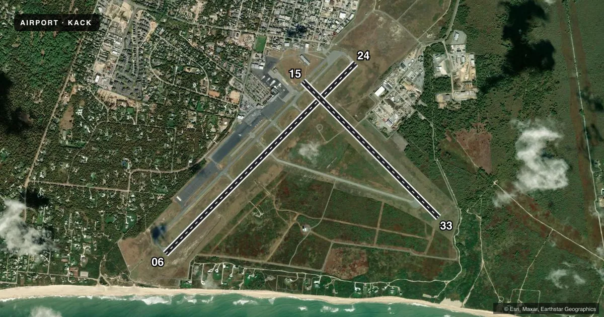
Runways & pattern
Full pagePattern entry · RWY 06
LEFT TRAFFIC| Runway | Heading (°M) | Length | Surface | Traffic |
|---|---|---|---|---|
| 06/24Favored | 31° / 211° | 6,303 ft | ASPH | Standard L |
| 15/33 | 121° / 301° | 4,500 ft | ASPH | Standard L |
Runway end performance
| End | TORA | TODA | ASDA | LDA | VGSI | Approach lights | Obstruction |
|---|---|---|---|---|---|---|---|
| 06 | 6,303' | 6,303' | 6,303' | 5,765' | PAPI 4-box right(3°) | MALSF | — |
| 24 | 6,303' | 6,303' | 6,303' | 6,303' | PAPI 4-box left(3°) | SSALR | — |
| 15 | 4,500' | 4,500' | 4,500' | 4,500' | — | — | 30', bldg, 800' from thr, 280' R of cntrln, slope 20 |
| 33 | 4,500' | 4,500' | 4,500' | 4,500' | PAPI 4-box left(3°) | — | — |
Declared distances in feet. TORA = takeoff run available, TODA = takeoff distance, ASDA = accelerate-stop, LDA = landing distance.
Airport sketch
Runways drawn to scale from FAA survey coordinates, rendered over satellite imagery. Not for navigation.
Approaches & charts
ILS · 2
Services on the field
Fuel grades, oxygen, maintenance, ramp storage and lighting — as declared to the FAA by the airport operator.
Fuel & services
- Fuel
- 100LLA+
- Oxygen (bottled)
- Not available
- Oxygen (bulk)
- Not available
- Airframe repair
- Not available
- Power plant repair
- Not available
- Other services
- AFRT,CHTR
Ramp & ground
- Transient storage
- Tie-down
- Hangar
- Landing fee
- Yes
- Customs
- Not available
- Lighting schedule
- SEE RMK
- Beacon schedule
- SS-SR
- Beacon
- White / Green (civil land)(WG)
- Wind indicator
- Lighted
- Segmented circle
- Yes
Fuel & FBOs
Cheapest 100LL and Jet A on the field and nearby. Always confirm with the FBO before taxi.
Airport notes
Surface conditions, obstructions, local procedures, lighting outages and other notes published with each FAA cycle.
General notes
- BE AWARE OF HIGH-SPD MIL JET & HVY HEL TFC VCNTY AIR STATION CAPE COD.
- ARPT HAS NOISE ABATEMENT PROCS CTC NOISE OFFICER 508-325-5300.
- DEER & BIRDS ON & INVOF ARPT.
- FOR CD IF TWR CLSD & UNA TO CTC FSS FREQ, CTC BOSTON APCH AT 603-594-5554.
- TWY F RSTRD TO SML ACFT 12500 LBS OR LESS.
- TXL F BTN TWY B & TWY H CLSD TO ACFT WITH WINGSPAN MORE THAN 79FT.
- ALL ACFT, APU USE LMTD TO 15 MIN.
Lighting notes
- WHEN ATCT CLSD ACTVT MALSF RWY 06; SSALR RWY 24; HIRL RWY 06/24; MIRL RWY 15/33; TWY LGTS - CTAF. PAPI RWY 06, 24 & 33 OPR 24 HRS.
Runway surface & condition
- 06/24PCR VALUE: 770/F/A/X/T
- 15/33PCR VALUE: 430/F/A/X/T
Approach & departure obstructions
- 24SSALR UNMON WHEN TWR CLSD.
Other notes
- ESTAB PRIOR TO 1959.
- ARFF INDEX C SVCS PRVD BTN 0600 AND 2200. FOR INDEX C SVCS BTN 2201 AND 0559, 2 HR PPR AT 508-325-7569 TO NANTUCKET AIRPORT OPS. PPR 2 HRS FOR UNSKED ACFT OPS WITH MORE THAN 9 PAX SEATS; CALL AMGR 508-325-5300.
- FEE FOR NON-COML ACFT PRKG.
VFR map & nearby airports
VFR sectional. Tap any ICAO chip to open that airport.
Key facts · KACK
Answer card- ICAO
- KACK
- Name
- NANTUCKET MEML
- Location
- NANTUCKET, MASSACHUSETTS
- Elevation
- 46.8 ft MSL
- Traffic pattern altitude
- 1,046.8 ft MSL (1,000 AGL)
- Control tower
- Towered · 0600-2200 MAY 15-SEP 30; 0600-2100 OCT 1-MAY 14
- Total runways
- 2
- Longest runway
- 06/24 · 6,303 ft
- Published ILS approaches
- 2
- Published frequencies
- 10
- Magnetic variation
- 14°
- Current flight rules
- VFR
- Current wind
- 010° at 10 kt
- Favored runway now
- RWY 06
Nantucket Memorial Airport sits on Nantucket in Massachusetts. Field elevation is 46.8 ft MSL. The airport has two asphalt runways. The longest is 06/24 at 6,303 ft. Runway 15/33 is 4,500 ft. The tower is open 0600-2200 May 15 through Sep 30. It is open 0600-2100 Oct 1 through May 14. Two ILS approaches are published for runways 06 and 24.
Pattern altitude is not published. Use 1,000 ft AGL for light piston traffic unless the current Chart Supplement says otherwise. Nantucket Memorial Airport is on the field. It carries 100LL and Jet A Prist. Call 508-325-5300 for current service details. The airport has noise abatement procedures. Contact the noise officer before arrival if you need the local flow. Deer and birds are reported on and near the airport. Plan for that on taxi, takeoff and landing.
When the tower is closed, lighting is still available. Runway 06 uses MALSF. Runway 24 has SSALR. Runways 06/24 have high intensity lights. Runway 15/33 has medium intensity lights. PAPI is published for 06, 24 and 33. Taxiway F is limited to small aircraft at 12,500 lb or less. Airspace details should be checked on the current chart before flight. Boston Approach handles clearance delivery and approach services when needed. Expect busy traffic in the area. Military jets and heavy helicopters operate near Air Station Cape Cod.