METAR & TAF KMVY
Current METAR
Observed 14:53Z
KMVY 271453Z 02007KT 10SM SCT110 23/10 A2984 RMK AO2 SLP104 T02330100 56003
- Wind
- 020° @ 7 kt
- Visibility
- 10 SM
- Temp / Dew
- 23°C / 10°C
- Altimeter
- 29.84 inHg
- Clouds
- SCT
- Density alt
- 1,142 ft
- Ceiling
- Unlimited
- Rules
- VFR
Airport info & contacts
Manager on record, flight service, ARTCC, attendance schedule and pattern altitude — published by the FAA and refreshed every 28 days.
Location
- From city
- 3 NM S
- VFR sectional
- NEW YORK
- ARTCC
- ZBW · BOSTON
- NOTAM facility
- MVY (NOTAM-D)
Airport manager
- Name
- GEOFFREY R. FREEMAN
- Phone
- 508-693-7022
- Address
- 71 AIRPORT RD, VINEYARD HAVEN MA 02568
Flight service · Hours
- FSS BDR
- BRIDGEPORT1-800-WX-BRIEF
- Attendance
- ALL
Frequencies
Tap any row to copy the frequency to your clipboard.
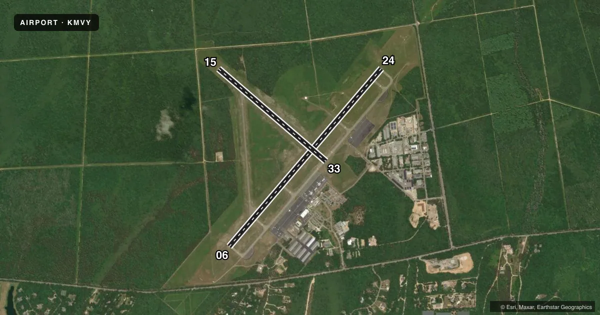
Runways & pattern
Full pagePattern entry · RWY 06
LEFT TRAFFIC| Runway | Heading (°M) | Length | Surface | Traffic |
|---|---|---|---|---|
| 06/24Favored | 26° / 206° | 5,504 ft | ASPH | 24 R |
| 15/33 | 116° / 296° | 3,327 ft | ASPH | 33 R |
Runway end performance
| End | TORA | TODA | ASDA | LDA | VGSI | Approach lights | Obstruction |
|---|---|---|---|---|---|---|---|
| 06 | 5,504' | 5,504' | 5,504' | 5,504' | PAPI 4-box right(3°) | — | 14', trees, 700' from thr, 350' R of cntrln, slope 34 |
| 24 | 5,504' | 5,504' | 5,504' | 5,504' | PAPI 4-box right(3°) | MALSR | — |
| 15 | 3,327' | 3,327' | 3,327' | 3,327' | — | — | 40', trees, 1500' from thr, 0' R of cntrln, slope 34 |
| 33 | 3,327' | 3,327' | 3,327' | 3,327' | — | — | 52', trees, 2000' from thr, 175' R of cntrln, slope 34 |
Declared distances in feet. TORA = takeoff run available, TODA = takeoff distance, ASDA = accelerate-stop, LDA = landing distance.
Airport sketch
Runways drawn to scale from FAA survey coordinates, rendered over satellite imagery. Not for navigation.
Approaches & charts
ILS · 1
Services on the field
Fuel grades, oxygen, maintenance, ramp storage and lighting — as declared to the FAA by the airport operator.
Fuel & services
- Fuel
- 100LLA
- Oxygen (bottled)
- Not available
- Oxygen (bulk)
- Not available
- Airframe repair
- Minor
- Power plant repair
- Minor
- Other services
- AFRT,CHTR
Ramp & ground
- Transient storage
- Tie-down
- Landing fee
- Yes
- Customs
- Not available
- Lighting schedule
- SEE RMK
- Beacon schedule
- SS-SR
- Beacon
- White / Green (civil land)(WG)
- Wind indicator
- Lighted
- Segmented circle
- Yes
Fuel & FBOs
Cheapest 100LL and Jet A on the field and nearby. Always confirm with the FBO before taxi.
Airport notes
Surface conditions, obstructions, local procedures, lighting outages and other notes published with each FAA cycle.
General notes
- TWY D FM RWY 06 TO RWY 15 CLSD TO ACFT WITH OVR 9 PAX.
- ARPT HAS NOISE ABATEMENT PROCS. CTC OPNS 508-693-7022. AVOID RESIDENTIAL AREAS SW OF ARPT.
- HELS PROHIBITED FM HOVER TAXI, LDG AND TKOF FM T-HNGRS.
- VOLUNTARY CURFEW ON ARRS & DEPS BTN 2200-0600.
Lighting notes
- WHEN ATCT CLSD ACTVT MALSR RWY 24; REIL RWY 33; HIRL RWY 06/24; MIRL RWY 15/33 - CTAF.
Runway surface & condition
- 06/24PCR VALUE: 200/F/A/X/T
- 15/33PCR VALUE: 90/F/A/X/T
- 15/33RWY 15/33 NOT AVBL FOR PART 121/PART 380 OPS WITH SKED PAX CARRYING OPS MORE THAN 9 PAX SEATS AND NON-SKED PAX CARRYING OPS MORE THAN 30 PAX SEATS.
Other notes
- ARPT EXISTED PRIOR TO 1959.
- 24-HR PPR FOR UNSKED ACR OPS WITH MORE THAN 9 PAX SEATS-CALL AMGR 508-693-7022.
- PRKG FEE ALL ACFT. LDG FEE ALL ACFT OVER 4000 LBS.
VFR map & nearby airports
VFR sectional. Tap any ICAO chip to open that airport.
Key facts · KMVY
Answer card- ICAO
- KMVY
- Name
- MARTHA'S VINEYARD
- Location
- VINEYARD HAVEN, MASSACHUSETTS
- Elevation
- 66.9 ft MSL
- Traffic pattern altitude
- 1,066.9 ft MSL (1,000 AGL)
- Control tower
- Towered · 0600-2200 MAY 15 - OCT 31; 0700-1700 NOV 1 MAY14
- Total runways
- 2
- Longest runway
- 06/24 · 5,504 ft
- Published ILS approaches
- 1
- Published frequencies
- 9
- Magnetic variation
- 15°
- Current flight rules
- VFR
- Current wind
- 020° at 7 kt
- Favored runway now
- RWY 06
Martha's Vineyard Airport sits in Vineyard Haven, Massachusetts. Field elevation is 66.9 ft MSL. The airport has 2 asphalt runways. The longest is 5,504 ft on runway 06/24. Runway 15/33 is 3,327 ft.
This is a towered field. The tower is open 0600-2200 May 15 through Oct 31. It is open 0700-1700 Nov 1 through May 14. One ILS is published. It serves runway 24. Pattern altitude is not published, so use standard 1,000 ft AGL for light piston unless the current Chart Supplement says otherwise.
Martha's Vineyard Airport is noise-sensitive. Published procedures call for avoiding residential areas southwest of the airport. There is also a curfew on arrivals and departures between 2200 and 0600. The airport has one on-field FBO, Martha's Vineyard Airport. It carries 100LL, Jet A and Jet A Prist. Call 508-693-7022 for current service details.
First-time visitors should pay attention to the operating limits. Taxiway D from runway 06 to runway 15 is closed to aircraft with more than nine passenger seats. Runway 15/33 is not available for certain scheduled and larger passenger-carrying operations. The field also requires 24-hour prior permission for unscheduled aircraft operations with more than nine passenger seats. Check the current Chart Supplement and call the airport operator before a larger arrival.