METAR & TAF KCQX
Current METAR
Observed 11:52Z
KCQX 201152Z AUTO VRB03KT 10SM CLR 21/13 A2998 RMK AO2 SLP153 T02060133 10206 20139 51022
- Wind
- VAR @ 3 kt
- Visibility
- 10 SM
- Temp / Dew
- 21°C / 13°C
- Altimeter
- 29.98 inHg
- Clouds
- CLR
- Density alt
- 724 ft
- Ceiling
- Unlimited
- Rules
- VFR
Airport info & contacts
Manager on record, flight service, ARTCC, attendance schedule and pattern altitude — published by the FAA and refreshed every 28 days.
Location
- From city
- 2 NM NW
- VFR sectional
- NEW YORK
- ARTCC
- ZBW · BOSTON
- NOTAM facility
- CQX (NOTAM-D)
Airport manager
- Name
- TIMOTHY HOWARD
- Phone
- 508-945-9000
- Address
- CHATHAM MUNICIPAL AIRPORT, GEORGE RYDER ROAD, CHATHAM MA 02633
Flight service · Hours
- FSS BDR
- BRIDGEPORT1-800-WX-BRIEF
- Attendance
- 0800-DUSK
Frequencies
Tap any row to copy the frequency to your clipboard.
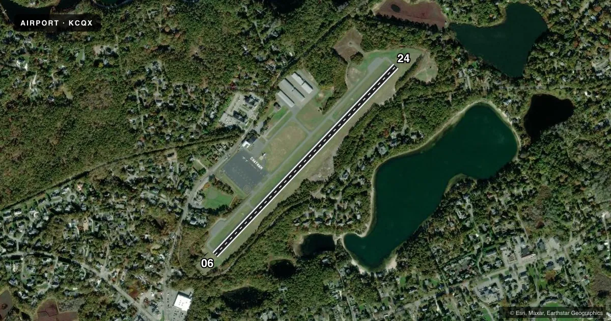
Runways & pattern
Full pagePattern entry · RWY 06
LEFT TRAFFICRunway end performance
| End | TORA | TODA | ASDA | LDA | VGSI | Approach lights | Obstruction |
|---|---|---|---|---|---|---|---|
| 06 | — | — | — | — | PAPI 2-box left(3.5°) | — | 120', trees, 800' from thr, 150' R of cntrln, slope 5 |
| 24 | — | — | — | — | PAPI 2-box right(3.5°) | — | 232', tank, 3100' from thr, 25' R of cntrln, slope 12 |
Declared distances in feet. TORA = takeoff run available, TODA = takeoff distance, ASDA = accelerate-stop, LDA = landing distance.
Airport sketch
Runways drawn to scale from FAA survey coordinates, rendered over satellite imagery. Not for navigation.
Approaches & charts
Services on the field
Fuel grades, oxygen, maintenance, ramp storage and lighting — as declared to the FAA by the airport operator.
Fuel & services
- Fuel
- 100LLAA+
- Oxygen (bottled)
- Not available
- Oxygen (bulk)
- Not available
- Airframe repair
- Major
- Power plant repair
- Minor
- Other services
- INSTR,RNTL
Ramp & ground
- Transient storage
- Tie-down
- Hangar
- Landing fee
- No fee published
- Customs
- Not available
- Lighting schedule
- SEE RMK
- Beacon schedule
- SS-SR
- Beacon
- White / Green (civil land)(WG)
- Wind indicator
- Yes
- Segmented circle
- Yes
Fuel & FBOs
Cheapest 100LL and Jet A on the field and nearby. Always confirm with the FBO before taxi.
Airport notes
Surface conditions, obstructions, local procedures, lighting outages and other notes published with each FAA cycle.
General notes
- BE AWARE OF HIGH-SPD MIL JET & HVY HEL TFC VCNTY CAPE COD CGAS.
- BIRDS PRIMLY GULLS AND WILDLIFE ON OR INVOF ARPT.
- RCMD MIN ALT OF 2000 FT AGL FM NORTHEAST TO SOUTHEAST OF ARPT OVER NATL SEASHORE .
- WATER LDG AREA CLSD PERMLY.
- NOISE ABATEMENT RWY 6/24: USE FULL RWY & AVOID INTXN DEPS. MINIMIZE OR AVOID TGL OPNS. CLIMB OUT ON RWY HDG TIL 1100 FT OVR WATER THEN PROCD ON CRS. REDUCE PWR AS SOON AS PRACTICAL.
- RWY 6/24, FLY PAT DOWNWIND LEG 1/2 TO 1 MILE OUT FM RWY AS PRACTICABLE.
- AVOID RESIDENTIAL AREAS AS MUCH AS PSBL.
- FOR CD CTC BOSTON APCH AT 603-594-5554.
- CHECK NOTAMS FOR TREE OBS ON APCH AREAS TO RWYS 06 & 24.
Lighting notes
- ACTVT MIRL RWY 06/24 - 122.95.
Other notes
- ESTAB PRIOR TO 1959.
VFR map & nearby airports
VFR sectional. Tap any ICAO chip to open that airport.
Key facts · KCQX
Answer card- ICAO
- KCQX
- Name
- CHATHAM MUNI
- Location
- CHATHAM, MASSACHUSETTS
- Elevation
- 63.6 ft MSL
- Traffic pattern altitude
- 1,063.6 ft MSL (1,000 AGL)
- Control tower
- Non-towered (use CTAF)
- Total runways
- 1
- Longest runway
- 06/24 · 3,001 ft
- Published ILS approaches
- 0
- Published frequencies
- 4
- Magnetic variation
- 16°
- Current flight rules
- VFR
- Current wind
- 000° at 3 kt
- Favored runway now
- RWY 06
Chatham Muni sits in Chatham, Massachusetts on Cape Cod. Field elevation is 63.6 ft MSL. The airport has one runway, 06/24, which is 3,001 ft long. There is no control tower. No ILS approaches are published here. Pattern altitude is not published. Use the standard 1,000 ft AGL for light piston traffic unless the current Chart Supplement says otherwise.
Cape Cod Flying Circus is on the field. It carries 100LL and Jet A. Call the FBO directly at (508) 945-9000 before arrival if you need current services. The airport remarks call out tree obstructions on the approach areas to runways 06 and 24. They also note noise abatement on 06/24. Use the full runway. Avoid intersection departures. Keep touch-and-go work to a minimum. Climb on runway heading until 1,100 ft over water, then proceed on course. Reduce power as soon as practical.
This is a coastal airport with bird activity in the area. The remarks also mention high-speed military jet traffic and heavy helicopter traffic near Cape Cod CGAS. For clearance delivery, Boston Approach handles it. The airport is near the National Seashore, so plan for the published minimum altitude guidance in that area. Check NOTAMs before departure. The water landing area is permanently closed.