METAR & TAF 28M
28M does not publish a METAR.
Showing the nearest reporting station: KGHG (MARSHFIELD MUNI - GEORGE HARLOW FLD) · 8.5 NM away. Conditions at 28M may differ.
METAR · KGHG
Observed 12:55Z
KGHG 271255Z AUTO 05005KT 10SM CLR 20/14 A2985 RMK AO2
- Wind
- 050° @ 5 kt
- Visibility
- 10 SM
- Temp / Dew
- 20°C / 14°C
- Altimeter
- 29.85 inHg
- Clouds
- CLR
- Density alt
- 775 ft
- Ceiling
- Unlimited
- Rules
- VFR
Airport info & contacts
Manager on record, flight service, ARTCC, attendance schedule and pattern altitude — published by the FAA and refreshed every 28 days.
Location
- From city
- 3 NM SE
- VFR sectional
- NEW YORK
- ARTCC
- ZBW · BOSTON
- NOTAM facility
- BDR (NOTAM-D)
Airport manager
- Name
- PETER OAKLEY
- Phone
- 508-889-4061
- Address
- 777 MONPONSET STREET, HANSON MA 02341
Flight service · Hours
- FSS BDR
- BRIDGEPORT1-800-WX-BRIEF
- Attendance
- MON-FRI · IREG
Frequencies
Tap any row to copy the frequency to your clipboard.
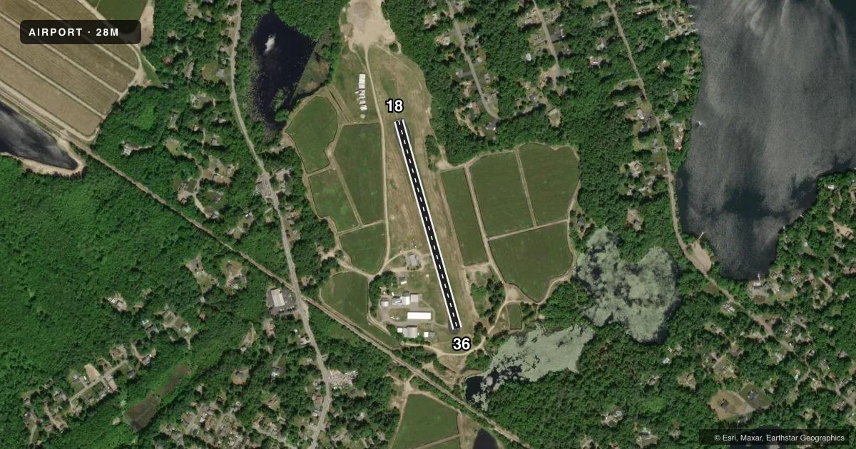
Runways & pattern
Full pagePattern entry · RWY 36
LEFT TRAFFICRunway end performance
| End | TORA | TODA | ASDA | LDA | VGSI | Approach lights | Obstruction |
|---|---|---|---|---|---|---|---|
| 18 | — | — | — | — | — | — | 60', trees, 1000' from thr, 130' R of cntrln, slope 14 |
| 36 | — | — | — | — | — | — | 60', trees, 800' from thr, 125' R of cntrln, slope 10 |
Declared distances in feet. TORA = takeoff run available, TODA = takeoff distance, ASDA = accelerate-stop, LDA = landing distance.
Airport sketch
Runways drawn to scale from FAA survey coordinates, rendered over satellite imagery. Not for navigation.
Approaches & charts
Services on the field
Fuel grades, oxygen, maintenance, ramp storage and lighting — as declared to the FAA by the airport operator.
Fuel & services
- Fuel
- Not available
- Airframe repair
- Not available
- Power plant repair
- Not available
- Other services
- PAJA
Ramp & ground
- Transient storage
- Tie-down
- Landing fee
- No fee published
- Customs
- Not available
- Wind indicator
- Yes
- Segmented circle
- No
Fuel & FBOs
Cheapest 100LL and Jet A on the field and nearby. Always confirm with the FBO before taxi.
Airport notes
Surface conditions, obstructions, local procedures, lighting outages and other notes published with each FAA cycle.
General notes
- FOR CD CTC BOSTON APCH AT 603-594-5554.
- WILDLIFE ON & INVOF ARPT.
- TGL T NOT ADZD.
- AVOID TAX OPS ON GRASS WHEN GND IS SATURATED.
Other notes
- THIS AIRPORT HAS BEEN SURVEYED BY THE NATIONAL GEODETIC SURVEY.
- NON-COMPLIANCE WITH FAR 157.
VFR map & nearby airports
VFR sectional. Tap any ICAO chip to open that airport.
Key facts · 28M
Answer card- ICAO
- 28M
- Name
- CRANLAND
- Location
- HANSON, MASSACHUSETTS
- Elevation
- 71 ft MSL
- Traffic pattern altitude
- 1,071 ft MSL (1,000 AGL)
- Control tower
- Non-towered (use CTAF)
- Total runways
- 1
- Longest runway
- 18/36 · 1,760 ft
- Published ILS approaches
- 0
- Published frequencies
- 1
- Magnetic variation
- 16°
- Current flight rules
- VFR
- Current wind
- 050° at 5 kt
- Favored runway now
- RWY 36
CRANLAND (28M) is in Hanson, Massachusetts. The field elevation is 71 ft MSL. It has one runway. Runway 18/36 is 1,760 ft long with asphalt pavement. The airport is non-towered. CTAF is 122.9. No ILS approaches are published here.
The pattern altitude is not published. For light piston work, use the standard 1,000 ft AGL pattern unless the current Chart Supplement says otherwise. The published remarks matter here. Touch-and-go landings are not advised. Wildlife is present on and near the airport. Avoid taxiing on grass when the ground is saturated. Clearance delivery is handled through Boston Approach at 603-594-5554.
There are no on-field FBOs listed in the facts. Contact the airport operator directly or call the field on CTAF for current services before you go. With a 1,760 ft runway and no published ILS, this is a field where planning and performance margins matter. Check the current Chart Supplement for any updated operating notes before departure.