METAR & TAF KBID
Current METAR
Observed 09:56Z
KBID 270956Z AUTO 00000KT 10SM BKN100 16/13 A2984 RMK AO2 SLP106 T01610133 PNO $
- Wind
- 000° @ 0 kt
- Visibility
- 10 SM
- Temp / Dew
- 16°C / 13°C
- Altimeter
- 29.84 inHg
- Clouds
- BKN
- Density alt
- 353 ft
- Ceiling
- 10,000 ft AGL
- Rules
- VFR
Airport info & contacts
Manager on record, flight service, ARTCC, attendance schedule and pattern altitude — published by the FAA and refreshed every 28 days.
Location
- From city
- 1 NM W
- VFR sectional
- NEW YORK
- ARTCC
- ZBW · BOSTON
- NOTAM facility
- BID (NOTAM-D)
Airport manager
- Name
- IFTIKHAR AHMAD
- Phone
- (401) 691-2265
- Address
- RHODE ISLAND AIRPORT CORP, 2000 POST RD, WARWICK RI 02886
Flight service · Hours
- FSS BDR
- BRIDGEPORT1-800-WX-BRIEF
- Attendance
- JUN-SEP · SUN-SAT · 0800-1700
- OCT-MAY · SUN-SAT · 0800-1600
Frequencies
Tap any row to copy the frequency to your clipboard.
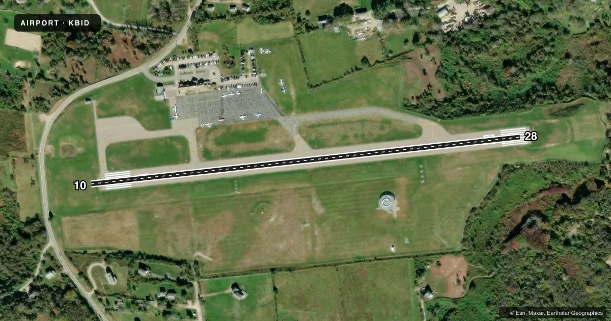
Runways & pattern
Full pagePattern entry · RWY 10
LEFT TRAFFICRunway end performance
| End | TORA | TODA | ASDA | LDA | VGSI | Approach lights | Obstruction |
|---|---|---|---|---|---|---|---|
| 10 | — | — | — | — | PAPI 4-box right(3.5°) | — | 88', trees, 2000' from thr, 40' R of cntrln, slope 20 |
| 28 | — | — | — | — | PAPI 4-box left(3°) | — | — |
Declared distances in feet. TORA = takeoff run available, TODA = takeoff distance, ASDA = accelerate-stop, LDA = landing distance.
Airport sketch
Runways drawn to scale from FAA survey coordinates, rendered over satellite imagery. Not for navigation.
Approaches & charts
Services on the field
Fuel grades, oxygen, maintenance, ramp storage and lighting — as declared to the FAA by the airport operator.
Fuel & services
- Fuel
- Not available
- Oxygen (bottled)
- Not available
- Oxygen (bulk)
- Not available
- Airframe repair
- Not available
- Power plant repair
- Not available
- Other services
- AFRT,AMB,CHTR,PAJA
Ramp & ground
- Transient storage
- Tie-down
- Landing fee
- Yes
- Customs
- Not available
- Lighting schedule
- SEE RMK
- Beacon schedule
- SS-SR
- Beacon
- White / Green (civil land)(WG)
- Wind indicator
- Lighted
- Segmented circle
- Yes
Fuel & FBOs
Cheapest 100LL and Jet A on the field and nearby. Always confirm with the FBO before taxi.
Airport notes
Surface conditions, obstructions, local procedures, lighting outages and other notes published with each FAA cycle.
General notes
- OBSTNS: LGTD TWRS 1 MI NE OF ARPT, 1/2 MI APART.
- DEER & BIRDS ON & INVOF ARPT.
- ARPT PRKG & SAFETY BRIEF AVBL ON LDG 122.85 MHZ OR CALL 401-466-5511.
- RWY CONDS MAY NOT BE MNT OR RPRTD WHEN AP IS UNATNDD. CTC RI AP CORPORATION OPS AT 401-691-2265.
- OVNGT PRKG FEE.
- FOR CD WHEN APCH CLSD CTC BOSTON ARTCC AT 603-879-6859.
- RWY 10/28 SAFETY AREA NOT STD SE
- +15 FT DROPOFF 130 FT FM RWY END, 150 LEFT.
Lighting notes
- ACTVT REIL RWY 10 & 28; PAPI RWY 10 & 28; MIRL RWY 10/28 - CTAF.
Approach & departure obstructions
- 28+9 FT FENCE, 0-200 FT FM RWY END, 150 FT L & 130 FT R.
Other notes
- THIS AIRPORT HAS BEEN SURVEYED BY THE NATIONAL GEODETIC SURVEY.
- EXISTED PRIOR TO 1959.
- COML & NON RHODE ISLAND REGISTERED ACFT.
VFR map & nearby airports
VFR sectional. Tap any ICAO chip to open that airport.
Key facts · KBID
Answer card- ICAO
- KBID
- Name
- BLOCK ISLAND STATE
- Location
- BLOCK ISLAND, RHODE ISLAND
- Elevation
- 107.9 ft MSL
- Traffic pattern altitude
- 1,107.9 ft MSL (1,000 AGL)
- Control tower
- Non-towered (use CTAF)
- Total runways
- 1
- Longest runway
- 10/28 · 2,502 ft
- Published ILS approaches
- 0
- Published frequencies
- 5
- Magnetic variation
- 15°
- Current flight rules
- VFR
- Current wind
- 000° at 0 kt
- Favored runway now
- –
Block Island State is on Block Island, Rhode Island. Field elevation is 107.9 ft MSL. The airport has one runway. Runway 10/28 is 2,502 ft long with an asphalt surface. There is no control tower. Pattern altitude is not published, so use the standard 1,000 ft AGL for light piston traffic unless the current Chart Supplement says otherwise.
No ILS approaches are published here. The airport uses CTAF 123.0 and UNICOM 123.0. Providence handles approach and departure on 125.75 and 319.2. Published remarks call out deer and birds in the airport area. They also note lighted towers about 1 mile northeast of the field. Runway 10/28 has REILs and PAPI on both ends. Medium intensity runway lights are controlled by CTAF.
There are no on-field FBOs listed in the facts. Check with the airport operator or the FBO directly by phone before arrival for current services. The published remarks also say runway conditions may not be maintained or reported when the airport is unattended. That matters here. The runway safety area is not standard. There is also a fence near runway end 28. Pilots should plan for a short coastal strip with limited margin. Expect changing wind and possible bird activity.