METAR & TAF KWST
Current METAR
Observed 12:53Z
KWST 271253Z AUTO 00000KT 10SM CLR 21/13 A2986 RMK AO2 SLP110 T02110133
- Wind
- 000° @ 0 kt
- Visibility
- 10 SM
- Temp / Dew
- 21°C / 13°C
- Altimeter
- 29.86 inHg
- Clouds
- CLR
- Density alt
- 895 ft
- Ceiling
- Unlimited
- Rules
- VFR
Airport info & contacts
Manager on record, flight service, ARTCC, attendance schedule and pattern altitude — published by the FAA and refreshed every 28 days.
Location
- From city
- 2 NM SE
- VFR sectional
- NEW YORK
- ARTCC
- ZBW · BOSTON
- NOTAM facility
- WST (NOTAM-D)
Airport manager
- Name
- IFTIKHAR AHMAD
- Phone
- 401-691-2265
- Address
- RHODE ISLAND AIRPORT CORP, 2000 POST RD, WARWICK RI 02886
Flight service · Hours
- FSS BDR
- BRIDGEPORT1-800-WX-BRIEF
- Attendance
- JUN-SEP · SUN-SAT · 0800-1700
- OCT-MAY · SUN-SAT · 0800-1600
Frequencies
Tap any row to copy the frequency to your clipboard.
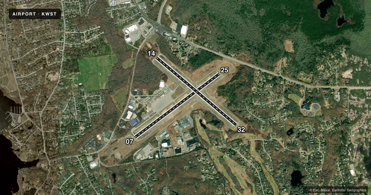
Runways & pattern
Full pagePattern entry · RWY 07
LEFT TRAFFIC| Runway | Heading (°M) | Length | Surface | Traffic |
|---|---|---|---|---|
| 07/25 | 38° / 218° | 4,010 ft | ASPH | Standard L |
| 14/32 | 115° / 295° | 3,960 ft | ASPH | Standard L |
Runway end performance
| End | TORA | TODA | ASDA | LDA | VGSI | Approach lights | Obstruction |
|---|---|---|---|---|---|---|---|
| 07 | — | — | — | — | PAPI 4-box right(3.5°) | MALSF | 117', trees, 2200' from thr, 330' R of cntrln, slope 17 |
| 25 | — | — | — | — | VASI 2-box left(3.5°) | — | 48', trees, 1100' from thr, 40' R of cntrln, slope 18 |
| 14 | — | — | — | — | PAPI 4-box left(4°) | — | 17', trees, 380' from thr, 140' R of cntrln, slope 10 |
| 32 | — | — | — | — | PAPI 4-box left(4°) | — | 33', trees, 425' from thr, 100' R of cntrln, slope 6 |
Declared distances in feet. TORA = takeoff run available, TODA = takeoff distance, ASDA = accelerate-stop, LDA = landing distance.
Airport sketch
Runways drawn to scale from FAA survey coordinates, rendered over satellite imagery. Not for navigation.
Approaches & charts
ILS · 1
Services on the field
Fuel grades, oxygen, maintenance, ramp storage and lighting — as declared to the FAA by the airport operator.
Fuel & services
- Fuel
- 100LLA
- Oxygen (bottled)
- Not available
- Oxygen (bulk)
- Not available
- Airframe repair
- Major
- Power plant repair
- Major
- Other services
- AFRT,AMB,AVNCS,CHTR,GLD,INSTR,PAJA,RNTL,SALES,TOW
Ramp & ground
- Transient storage
- Tie-down
- Landing fee
- Yes
- Customs
- Not available
- Lighting schedule
- SEE RMK
- Beacon schedule
- SS-SR
- Beacon
- White / Green (civil land)(WG)
- Wind indicator
- Lighted
- Segmented circle
- Yes
Fuel & FBOs
Cheapest 100LL and Jet A on the field and nearby. Always confirm with the FBO before taxi.
Airport notes
Surface conditions, obstructions, local procedures, lighting outages and other notes published with each FAA cycle.
General notes
- DEER & BIRDS ON & INVOF ARPT.
- RWY CONDS MAY NOT BE MNT OR RPRTD WHEN AP IS UNATNDD. CTC RI AP CORPORATION OPS AT 401-691-2265.
- OVNGT PRKG FEE.
- ARPT LCTD IN NOISE SENSITIVE AREA. POPULATED AREAS TO THE S & W SHOULD BE AVOIDED.
- HEL TOURS & BANNER TOW OPS ON AIRFIELD BLW 1000 FT ALG SOUTHERN COAST OF RHODE ISLAND.
- NOISE ABATEMENT PROCS IN EFCT CTC AMGR AT 401-691-2265.
- RWY 07/25 IS PREFERRED CALM WIND RWY.
- FOR AFT HRS TRML APRON ACES CTC AMGR 401-691-2265.
- RWY 07/25 UNEVEN PAVEMENT APRXLY 1000 FT FM AER 25 THR. CTC AMGR 401-691-2265.
- FOR CD CTC PROVIDENCE APCH AT 401-738-8945, WHEN APCH CLSD CTC BOSTON ARTCC AT 603-879-6859.
- GLDRS OPR FM ARPT ON INTMNT BASIS.
Lighting notes
- DUSK-DAWN. ACTVT MALSF RWY 07; REIL RWY 25, 14 & 32; PAPI RWY 7, 14 & 32, VASI RWY 25; MIRL RWY 07/25 & 14/32 - CTAF.
Fuel notes
- 100LLSELF SVC 100LL FUEL AVBL 24 HRS.
- AAVBL AT DOONEY AVIATION.
Approach & departure obstructions
- 14+10 FT TREES, 100 FT FM THR, 110 FT L; +10 FT TREES, 100 FT FM THR, 120 FT R.
- 25+10 FT TREES, 170 FT - 200 FT FM THR, 180 FT L.
- 32+20 FT TREES, 200 FT FM THR, 125 FT L.
- 07TEMPO DTHR 375 FT.
- 14TEMPO DTHR 595 FT.
- 07PAPI U/S.
- 14PAPI U/S.
- 0722:1 TO TEMPO DTHR.
- 1422:1 TO TEMPO DTHR.
- 3222:1 TO DTHR.
Other notes
- ARPT EXISTED PRIOR TO 1959.
- LDG FEE FOR COML & NON-RHODE ISLAND REGISTERED ACFT.
VFR map & nearby airports
VFR sectional. Tap any ICAO chip to open that airport.
Key facts · KWST
Answer card- ICAO
- KWST
- Name
- WESTERLY STATE
- Location
- WESTERLY, RHODE ISLAND
- Elevation
- 81.1 ft MSL
- Traffic pattern altitude
- 1,081.1 ft MSL (1,000 AGL)
- Control tower
- Non-towered (use CTAF)
- Total runways
- 2
- Longest runway
- 07/25 · 4,010 ft
- Published ILS approaches
- 1
- Published frequencies
- 4
- Magnetic variation
- 15°
- Current flight rules
- VFR
- Current wind
- 000° at 0 kt
- Favored runway now
- –
Westerly State Airport sits in Westerly, Rhode Island. Field elevation is 81.1 ft MSL. The airport has two asphalt runways. The longest is runway 07/25 at 4,010 ft. Runway 14/32 is 3,960 ft. There is no control tower, so use CTAF 123.0 for traffic calls. Be ready to work with Providence Approach on 119.45 or 319.2 when needed.
One ILS is published here. It serves runway 07. The published pattern altitude is not listed, so use the standard 1,000 ft AGL for light piston traffic unless the current Chart Supplement says otherwise. The field is in a noise sensitive area. Populated areas south and west should be avoided. That matters here. Helicopter tours and banner tow ops also work the southern coast below 1,000 ft, so keep your scan sharp.
FlightLevel Aviation is on the field. It carries 100LL, Jet A and Jet A Prist. Dooney Aviation is also on the field. It carries 100LL and Jet A Prist. Self-serve 100LL is available 24 hours. Runway 07/25 has uneven pavement about 1,000 ft from the approach end of runway 25. Runway 14 has a 22 to 1 obstacle clearance slope to a temporary displaced threshold. Runway 07 has the same note. Runway 32 has trees near the threshold. Lighting is dusk to dawn. If the airport is unattended, runway conditions may not be maintained or reported. Call Rhode Island Airport Corporation operations before you go if you need current field status.