METAR & TAF KOQU
Current METAR
Observed 12:50Z
KOQU 271250Z 00000KT 10SM BKN100 20/12 A2984
- Wind
- 000° @ 0 kt
- Visibility
- 10 SM
- Temp / Dew
- 20°C / 12°C
- Altimeter
- 29.84 inHg
- Clouds
- BKN
- Density alt
- 722 ft
- Ceiling
- 10,000 ft AGL
- Rules
- VFR
Airport info & contacts
Manager on record, flight service, ARTCC, attendance schedule and pattern altitude — published by the FAA and refreshed every 28 days.
Location
- From city
- 3 NM NE
- VFR sectional
- NEW YORK
- ARTCC
- ZBW · BOSTON
- NOTAM facility
- OQU (NOTAM-D)
Airport manager
- Name
- IFTIKHAR AHMAD
- Phone
- 401-691-2000
- Address
- RHODE ISLAND AIRPORT CORP, 2000 POST RD, WARWICK RI 02886
Flight service · Hours
- FSS BDR
- BRIDGEPORT1-800-WX-BRIEF
- Attendance
- Unattended · SUN-SAT · 2200-0700
- Unattended
Frequencies
Tap any row to copy the frequency to your clipboard.
Runways & pattern
Full pagePattern entry · RWY 16
LEFT TRAFFIC| Runway | Heading (°M) | Length | Surface | Traffic |
|---|---|---|---|---|
| 16/34 | 130° / 310° | 7,000 ft | ASPH | Standard L |
| 05/23 | 19° / 199° | 4,000 ft | ASPH | Standard L |
Runway end performance
| End | TORA | TODA | ASDA | LDA | VGSI | Approach lights | Obstruction |
|---|---|---|---|---|---|---|---|
| 16 | 7,000' | 7,000' | 7,000' | 7,000' | PAPI 4-box left(3°) | MALSR | 45', trees, 1400' from thr, 300' R of cntrln, slope 26 |
| 34 | 7,000' | 7,000' | 7,000' | 7,000' | PAPI 4-box left(3°) | — | — |
| 05 | — | — | — | — | PAPI 4-box left(3°) | — | 12', pole, 360' from thr, 100' R of cntrln, slope 13 |
| 23 | — | — | — | — | PAPI 4-box right(3°) | — | — |
Declared distances in feet. TORA = takeoff run available, TODA = takeoff distance, ASDA = accelerate-stop, LDA = landing distance.
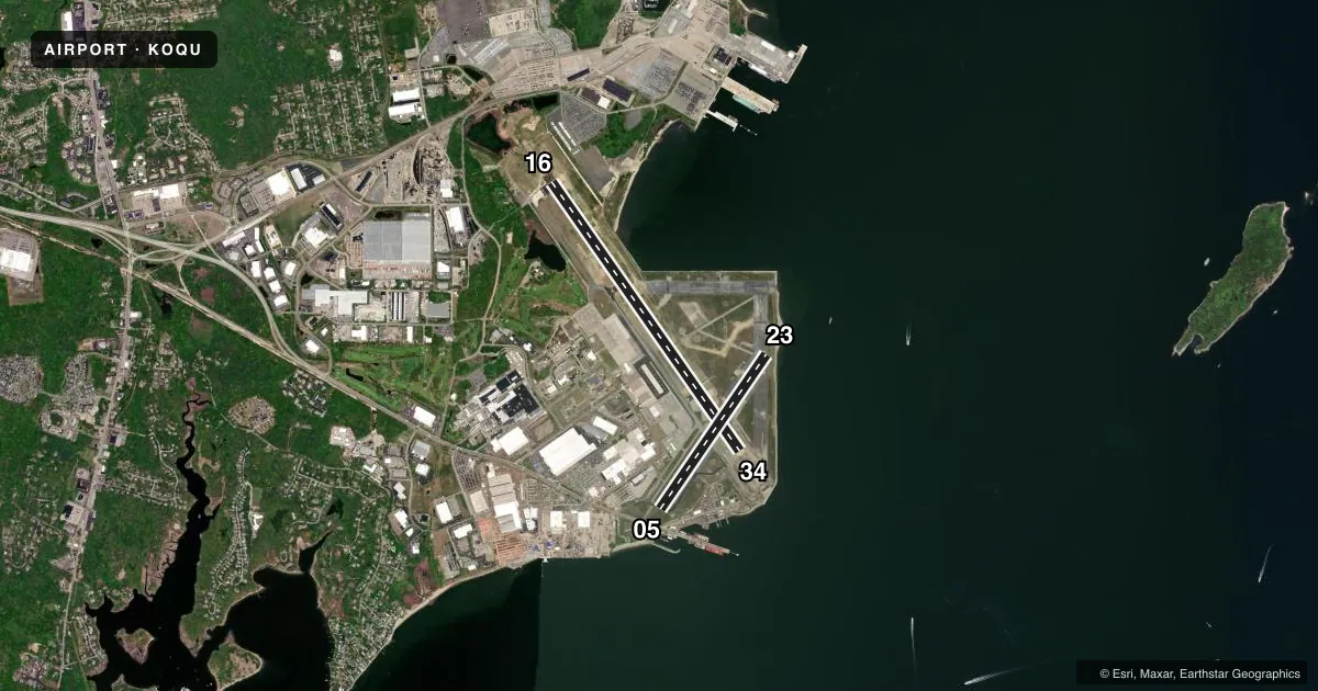
Airport sketch
Runways drawn to scale from FAA survey coordinates, rendered over satellite imagery. Not for navigation.
Approaches & charts
ILS · 1
Services on the field
Fuel grades, oxygen, maintenance, ramp storage and lighting — as declared to the FAA by the airport operator.
Fuel & services
- Fuel
- 100LLA
- Oxygen (bottled)
- Not available
- Oxygen (bulk)
- Not available
- Other services
- INSTR,RNTL
Ramp & ground
- Transient storage
- Tie-down
- Landing fee
- No fee published
- Customs
- Not available
- Lighting schedule
- SEE RMK
- Beacon schedule
- SS-SR
- Beacon
- White / Green (civil land)(WG)
- Wind indicator
- Lighted
- Segmented circle
- Yes
Fuel & FBOs
Cheapest 100LL and Jet A on the field and nearby. Always confirm with the FBO before taxi.
Airport notes
Surface conditions, obstructions, local procedures, lighting outages and other notes published with each FAA cycle.
General notes
- DEER, BIRDS & WATERFOWL ON & INVOF ARPT.
- TWY R & TWY E CLSD INDEFLY.
- RWY CONDS MAY NOT BE MNT OR RPRTD WHEN ARPT IS UNATNDD. CTC RI ARPT CORPORATION OPS AT 401-691-2265.
- LGTD CRANES 125 FT HIGH AT PIER 1000 FT SE OF RWY 05.
- FUEL: J8(MIL) A+ (FBO OPR 1100-0200Z++. PPR MANDATORY DUR NON-DUTY HR. CTC C401-295-5020) (NC-100LL, A).
- MILITARY: RSTD: 180 DEG TURNS FOR ACFT OVER 12500 LB GWT PROH ON RWY 16/34.
- MILITARY: ARNG: OPR 1200-2230Z++ TUE-FRI, EXC HOL. PPR FOR TSNT MIL ACFT LDG, PRKG ARNG RAMP & FUEL CTC DSN 247-4539, C401-275-4539. LTD PRKG, FUEL & MAINT AVBL, PRKG PAD 3 CLSD UFN. CALL HOPE OPS 274.30 (PRI), 36.80 (ALTN). PPR TO USE LCL TRG AREA.
- MILITARY: ANG: PPR FOR SVCG & USE OF ANG PRKG RAMP ONLY. AMOPS OPS 1200-2230Z++ TUES-FRI, EXCP HOL, DSN 476-3404/3405. TSNT ACFT INBD TO ANG PRKG RAMP CTC QUAHOG, COMD POST, 15 MIN PRIOR TO LDG.
- MILITARY: ANG: BASH PROGRAM IN EFF. 1 JUL-31 OCT ARE THE DSGND BASH PHASE II PERIODS FOR MIGRATORY BIRD ACT. INCRD HAZ FM CANADIAN GEESE FLYING EAST TO WEST OVER RWY. INBD ACFT CTC QUAHOG/RHODY OPS FOR LATEST BIRD WATCH CONDS.
- MILITARY: ANG: TMPRY STORAGE OF CLASSIFIED MTRLS UP TO SECRET AT COMD POST. ACFT REQ CUST/AG CTC AMOPS 7 DAYS PRIOR TO ARR.
- FUEL: A++ AVBL.
- FOR CD WHEN APCH CLSD CTC BOSTON ARTCC AT 603-879-6859.
- NMRS CRANES ON & INVOF ARPT.
- CIVIL ACFT USE CTN, HEIGHTENED SCTY MEASURES IN EFCT ON ANG AND ARMY RAMPS UFN.
- MILITARY: ANG: TWY N PCN 22/F/B/W/T-OG/CC APVL FOR C-130H/J WITH OPR WT UP TO 175000 LBS. ALL OTR ACFT OVR TWY N PCN RQR APVL FM OG/CC THRU AFLD MGMT.
Lighting notes
- ACTVT MALSR RWY 16; REIL RWY 05 & 23; PAPI RWY 05 & 23; MIRL RWY 05/23; HIRL RWY 16/34; TWY LGTS - CTAF.
Approach & departure obstructions
- 168000 FT AVBL FOR MIL ACFT ONLY.
- 34APCH RATIO 50:1 TO DTHR.
Other notes
- FLT NOTIFICATION SVC /ADCUS/ AVBL.
- LDG FEE COML & NON RHODE ISLAND REGISTERED ACFT/OVNGT PRKG FEE.
- MIL TFC PAT ROTARY WING 700 FT; FIXED WING 1000 FT AGL.
- 05/23RWY 23 UNEVEN PAVEMENT APRXLY 100-400 FT FM AER 23 THR. CTC AMGR 401-295-5020.
VFR map & nearby airports
VFR sectional. Tap any ICAO chip to open that airport.
Key facts · KOQU
Answer card- ICAO
- KOQU
- Name
- QUONSET STATE
- Location
- NORTH KINGSTOWN, RHODE ISLAND
- Elevation
- 18.2 ft MSL
- Traffic pattern altitude
- 1,018.2 ft MSL (1,000 AGL)
- Control tower
- Towered · TUE-FRI 0800-2300; SAT 0900-1700; SUN 1000-1800; CLSD MON & HOLS.
- Total runways
- 2
- Longest runway
- 16/34 · 7,000 ft
- Published ILS approaches
- 1
- Published frequencies
- 13
- Magnetic variation
- 15°
- Current flight rules
- VFR
- Current wind
- 000° at 0 kt
- Favored runway now
- –
Quonset State Airport sits in North Kingstown, Rhode Island. Field elevation is 18.3 ft MSL. The airport has two asphalt runways. The longest is 7,000 ft on 16/34. Runway 05/23 is 4,000 ft. The tower is open Tue-Fri 0800-2300, Sat 0900-1700 and Sun 1000-1800. It is closed Monday and holidays. There is one ILS approach. It serves runway 16. Pattern altitude is not published. Use 1,000 ft AGL for light piston traffic unless the current Chart Supplement says otherwise.
FlightLevel Aviation is on the field. It carries 100LL, Jet A and Jet A Prist. The published remarks also note avgas plus plus availability. If you need current fuel or ramp details, call the FBO directly. The field has a few operational items worth planning for. Runway 23 has uneven pavement about 100 to 400 ft from the threshold. Lighted cranes 125 ft high are located about 1,000 ft southeast of runway 05. There is also a military presence on the field. Transient crews should check the current Chart Supplement and coordinate early if they need access to restricted areas. The airport is close to the coast. Expect a busy local flow and stay sharp on runway alignment, especially with the towered schedule and the single ILS on 16.