METAR & TAF KHFD
Current METAR
Observed 16:53Z
KHFD 271653Z 16004KT 10SM SCT025 SCT045 27/18 A2981 RMK AO2 LTG DSNT NW SLP096 T02720183 $
- Wind
- 160° @ 4 kt
- Visibility
- 10 SM
- Temp / Dew
- 27°C / 18°C
- Altimeter
- 29.81 inHg
- Clouds
- SCT
- Density alt
- 1,599 ft
- Ceiling
- Unlimited
- Rules
- VFR
Airport info & contacts
Manager on record, flight service, ARTCC, attendance schedule and pattern altitude — published by the FAA and refreshed every 28 days.
Location
- From city
- 3 NM SE
- VFR sectional
- NEW YORK
- ARTCC
- ZBW · BOSTON
- NOTAM facility
- HFD (NOTAM-D)
Airport manager
- Name
- PELLEGRINO, ROBERT
- Phone
- 860-982-2443
- Address
- 239 MAXIM ROAD, HARTFORD CT 06114
Flight service · Hours
- FSS BDR
- BRIDGEPORT1-800-WX-BRIEF
- Attendance
- APR-NOV · 0700-2100
- DEC-MAR · 0700-1900
Frequencies
Tap any row to copy the frequency to your clipboard.
Runways & pattern
Full pagePattern entry · RWY 20
LEFT TRAFFIC| Runway | Heading (°M) | Length | Surface | Traffic |
|---|---|---|---|---|
| 02/20Favored | 354° / 174° | 4,417 ft | ASPH | Standard L |
| NE/SW | 354° / 174° | 2,323 ft | TURF | Standard L |
| 11/29 | 84° / 264° | 2,314 ft | ASPH | Standard L |
Runway end performance
| End | TORA | TODA | ASDA | LDA | VGSI | Approach lights | Obstruction |
|---|---|---|---|---|---|---|---|
| 02 | — | — | — | — | PAPI 4-box left(3.5°) | — | 100', trees, 1263' from thr, 300' R of cntrln, slope 10 |
| 20 | — | — | — | — | PAPI 4-box right(4°) | — | 80', trees, 238' from thr, 252' R of cntrln, slope 1 |
| NE | — | — | — | — | — | — | 68', trees, 624' from thr, 195' R of cntrln, slope 9 |
| SW | — | — | — | — | — | — | 91', trees, 1885' from thr, 0' R of cntrln, slope 20 |
| 11 | — | — | — | — | — | — | 56', trees, 550' from thr, 18' R of cntrln, slope 6 |
| 29 | — | — | — | — | — | — | 88', trees, 714' from thr, 175' R of cntrln, slope 5 |
Declared distances in feet. TORA = takeoff run available, TODA = takeoff distance, ASDA = accelerate-stop, LDA = landing distance.
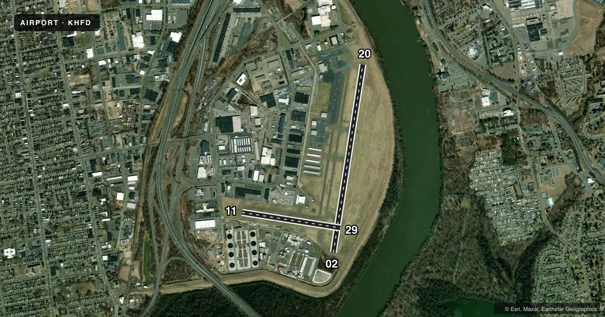
Airport sketch
Runways drawn to scale from FAA survey coordinates, rendered over satellite imagery. Not for navigation.
Approaches & charts
ILS · 1
Services on the field
Fuel grades, oxygen, maintenance, ramp storage and lighting — as declared to the FAA by the airport operator.
Fuel & services
- Fuel
- 100LLA
- Oxygen (bottled)
- Not available
- Oxygen (bulk)
- Not available
- Airframe repair
- Major
- Power plant repair
- Major
- Other services
- AFRT,AVNCS,CHTR,INSTR,RNTL,SALES
Ramp & ground
- Transient storage
- Tie-down
- Hangar
- Landing fee
- No fee published
- Customs
- Not available
- Lighting schedule
- SEE RMK
- Beacon schedule
- SS-SR
- Beacon
- White / Green (civil land)(WG)
- Wind indicator
- Lighted
- Segmented circle
- Yes
Fuel & FBOs
Cheapest 100LL and Jet A on the field and nearby. Always confirm with the FBO before taxi.
Airport notes
Surface conditions, obstructions, local procedures, lighting outages and other notes published with each FAA cycle.
General notes
- BIRDS & DEER ON & INVOF ARPT.
- ARPT LCTD IN NOISE SENSITIVE AREA. POPULATED AREAS TO SOUTH & WEST SHOULD BE AVOIDED. APCH/DEP OVR RIVER WHEN PSBL. SEE BRAINARD TWR LTRS TO AIRMEN.
- VOLUNTARY COMPLIANCE REQSTD - NO TGL & PRACTICE INST APCH MON THRU SAT 2200-0600 & SUN 2200-0900.
- TURF NE/SW RWY CLSD DURG WINTER MONTHS FM NOV 2 TO APR 30 EXC FOR SKI-EQUIPPED ACFT & HEL TRNG.
- CTN HFD IS LCTD ON W SIDE OF RIVER. CLSD ARPT 1 MILE ENE OF HFD ON E SIDE OF RIVER.
- WHEN ATCT CLSD, FOR CD CTC BRADLEY APCH 860-386-3597.
Lighting notes
- WHEN ATCT CLSD, ACTVT REIL RWYS 02 & 20; HIRL RWY 02/20 - CTAF. PAPI RWY 02 & 20 OPR CONSLY.
Approach & departure obstructions
- 023 FT GND, 0 FT DSTC, 150 FT R.
- 2027 FT BERM, 0-199 FT DSTC, 171-57 FT L.
- 20RWY 20 PAPI UNUSBL BYD 7 DEGS L OF RCL.
- 02APCH RATIO 20:1 TO DTHR.
- 20APCH RATIO 16:1 TO DTHR.
- 29APCH RATIO 11:1 TO DTHR.
- H1HNGR (26 FT HIGH AT 290 DEGS WEST) 234 FT FROM HELI.
Other notes
- EXISTED PRIOR TO 1959.
- ARPT CLSD TO ACR OPNS.
- LDG FEE FOR BUS/CORPORATE & REVENUE PRODUCING ACFT.
VFR map & nearby airports
VFR sectional. Tap any ICAO chip to open that airport.
Key facts · KHFD
Answer card- ICAO
- KHFD
- Name
- HARTFORD-BRAINARD
- Location
- HARTFORD, CONNECTICUT
- Elevation
- 18.3 ft MSL
- Traffic pattern altitude
- 1,018.3 ft MSL (1,000 AGL)
- Control tower
- Towered · 0600-0000
- Total runways
- 3
- Longest runway
- 02/20 · 4,417 ft
- Published ILS approaches
- 1
- Published frequencies
- 11
- Magnetic variation
- 15°
- Current flight rules
- VFR
- Current wind
- 160° at 4 kt
- Favored runway now
- RWY 20
Hartford-Brainard is in Hartford, Connecticut. Field elevation is 18.3 ft MSL. It has two asphalt runways. The longest is runway 02/20 at 4,417 ft. The tower is open 0600 to 0000. One ILS is published for runway 02. Pattern altitude is not published, so use the standard 1,000 ft AGL for light piston operations unless the current Chart Supplement says otherwise.
Hartford Jet Center is the on-field FBO. It carries 100LL, Jet A and Jet A Prist. Call them at (860) 548-9334 for current service details. The airport sits on the west side of the river. It is about 1 mile east-northeast of Hartford on the east side of the river. Published remarks also call out several obstructions near the runway ends. Runway 20 has a berm near the approach end. Runway 02 has a small ground obstruction off the right side. Runway 20 PAPI is unusable beyond 7 degrees left of centerline.
This field is closed to aircraft operations. Check the current Chart Supplement and call the airport operator before planning any arrival. There is also voluntary quiet time for touch-and-goes and practice instrument work overnight. Business, corporate and revenue-producing aircraft are subject to a landing fee. For a first-time pilot, the big items are the published closure, the towered environment and the nearby river setting. Verify any operational details with the airport operator before you go.