METAR & TAF 7B9
7B9 does not publish a METAR.
Showing the nearest reporting station: KBDL (BRADLEY INTL) · 10.2 NM away. Conditions at 7B9 may differ.
METAR · KBDL
Observed 12:51Z
KBDL 271251Z VRB03KT 10SM FEW100 FEW250 21/14 A2985 RMK AO2 SLP108 T02060139 $
- Wind
- VAR @ 3 kt
- Visibility
- 10 SM
- Temp / Dew
- 21°C / 14°C
- Altimeter
- 29.85 inHg
- Clouds
- FEW
- Density alt
- 1,121 ft
- Ceiling
- Unlimited
- Rules
- VFR
Airport info & contacts
Manager on record, flight service, ARTCC, attendance schedule and pattern altitude — published by the FAA and refreshed every 28 days.
Location
- From city
- 2 NM N
- VFR sectional
- NEW YORK
- ARTCC
- ZBW · BOSTON
- NOTAM facility
- BDR (NOTAM-D)
Airport manager
- Name
- BRIAN KNIGHT
- Phone
- 860-614-1854
- Address
- 3 WINGSTONE LN, DEVON PA 19333-0021
Flight service · Hours
- FSS BDR
- BRIDGEPORT1-800-WX-BRIEF
- Attendance
- 0800-1800
Frequencies
Tap any row to copy the frequency to your clipboard.
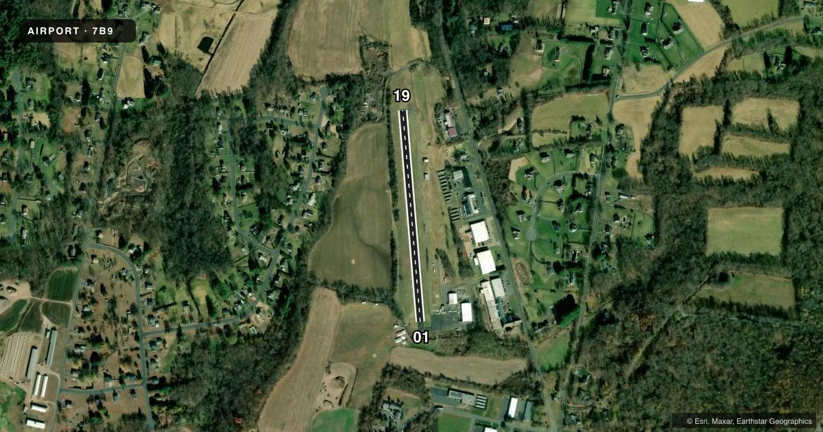
Runways & pattern
Full pagePattern entry · RWY 01
LEFT TRAFFICRunway end performance
| End | TORA | TODA | ASDA | LDA | VGSI | Approach lights | Obstruction |
|---|---|---|---|---|---|---|---|
| 01 | — | — | — | — | — | — | 61', trees, 384' from thr, 125' R of cntrln, slope 3 |
| 19 | — | — | — | — | — | — | 35', trees, 401' from thr, 90' R of cntrln, slope 5 |
Declared distances in feet. TORA = takeoff run available, TODA = takeoff distance, ASDA = accelerate-stop, LDA = landing distance.
Airport sketch
Runways drawn to scale from FAA survey coordinates, rendered over satellite imagery. Not for navigation.
Approaches & charts
Services on the field
Fuel grades, oxygen, maintenance, ramp storage and lighting — as declared to the FAA by the airport operator.
Fuel & services
- Fuel
- 100LL
- Airframe repair
- Major
- Power plant repair
- Major
- Other services
- INSTR,PAJA,SALES
Ramp & ground
- Transient storage
- Tie-down
- Hangar
- Customs
- Not available
- Lighting schedule
- SEE RMK
- Wind indicator
- Lighted
- Segmented circle
- No
Fuel & FBOs
Cheapest 100LL and Jet A on the field and nearby. Always confirm with the FBO before taxi.
Airport notes
Surface conditions, obstructions, local procedures, lighting outages and other notes published with each FAA cycle.
General notes
- EXTSV HEL TRNG OPNS.
- NON-STD THR LGTS.
- FOR CD CTC BRADLEY APCH AT 860-386-3597.
- ACFT TFC PAT ON E SIDE OF ARPT ONLY. HEL TFC PAT ON W SIDE OF ARPT ONLY.
- TWY PAVEMENT FAILED, EXTSV CRACKING, PATCHES, LOOSE AGGREGATE AND SML STONES.
Lighting notes
- NON-STD LIRL OPR DUSK-2400; FOR LGTS AFT 0000 CALL 860-871-2054 DURG BUS HRS.
Runway surface & condition
- 01/19NON-STD LIRL DUE TO SPACING, THR LGTS OUTBOARD OF RWY.
Approach & departure obstructions
- 016 FT SIGN, 66 FT DSTC, 103 FT L.
- 1925 FT TREES, 0-199 FT DSTC, 105 FT R.
- 01MKGS FADED.
- 19MKGS FADED.
Other notes
- VFR USE ONLY.
- MANAGERADDL CTC ROBERT SMITH, 860-930-9235.
VFR map & nearby airports
VFR sectional. Tap any ICAO chip to open that airport.
Key facts · 7B9
Answer card- ICAO
- 7B9
- Name
- ELLINGTON
- Location
- ELLINGTON, CONNECTICUT
- Elevation
- 253 ft MSL
- Traffic pattern altitude
- 1,253 ft MSL (1,000 AGL)
- Control tower
- Non-towered (use CTAF)
- Total runways
- 1
- Longest runway
- 01/19 · 1,800 ft
- Published ILS approaches
- 0
- Published frequencies
- 2
- Magnetic variation
- 15°
- Current flight rules
- VFR
- Current wind
- 000° at 3 kt
- Favored runway now
- RWY 01
Ellington Airport (7B9) is in Ellington, Connecticut. The field elevation is 253 ft MSL. It has one runway, 01/19, which is 1,800 ft long. There is no control tower. CTAF and UNICOM are both 123.0. No ILS approaches are published here, so plan for VFR only unless current procedures change.
The published pattern altitude is not listed. Use the standard 1,000 ft AGL pattern for light piston aircraft unless the current Chart Supplement says otherwise. The airport has one on-field FBO, Connecticut Parachutists. It carries 100LL. Call (860) 871-0021 for current service details.
A few remarks matter here. Runway 01/19 has non-standard low intensity lights with threshold lights set outboard of the runway. The lights operate from dusk to 2400. For lights after 0000, call the published number during business hours. Runway 19 markings are faded. Taxiway pavement is in poor shape with cracking, patches, loose aggregate and small stones. There are also 25 ft trees near the runway end on the 19 side, plus a 6 ft sign near the 01 end. Traffic pattern is east side only for airplanes. Helicopter pattern is west side only. This is a VFR-only field. Check the current Chart Supplement and coordinate with the airport or FBO before arrival.