METAR & TAF KIJD
Current METAR
Observed 12:52Z
KIJD 271252Z AUTO 00000KT 10SM CLR 18/14 A2986 RMK AO2 SLP111 T01830139
- Wind
- 000° @ 0 kt
- Visibility
- 10 SM
- Temp / Dew
- 18°C / 14°C
- Altimeter
- 29.86 inHg
- Clouds
- CLR
- Density alt
- 740 ft
- Ceiling
- Unlimited
- Rules
- VFR
Airport info & contacts
Manager on record, flight service, ARTCC, attendance schedule and pattern altitude — published by the FAA and refreshed every 28 days.
Location
- From city
- 3 NM NE
- VFR sectional
- NEW YORK
- ARTCC
- ZBW · BOSTON
- NOTAM facility
- IJD (NOTAM-D)
Airport manager
- Name
- ROBERT PELLIGRINO
- Phone
- 860-982-2443
- Address
- CONNECTICUT AIRPORT AUTHORITY, 239 MAXIM RD, HARTFORD CT 06114
Flight service · Hours
- FSS BDR
- BRIDGEPORT1-800-WX-BRIEF
- Attendance
- UNATTENDED
Frequencies
Tap any row to copy the frequency to your clipboard.
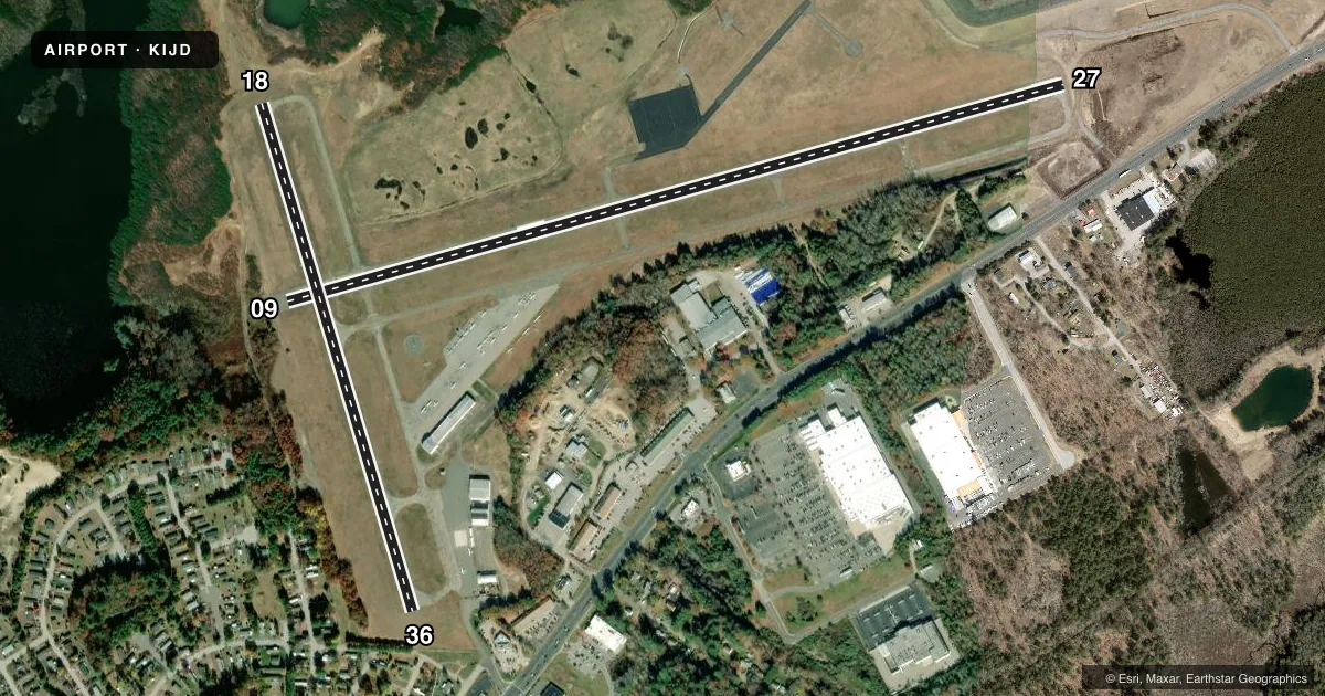
Runways & pattern
Full pagePattern entry · RWY 09
LEFT TRAFFIC| Runway | Heading (°M) | Length | Surface | Traffic |
|---|---|---|---|---|
| 09/27 | 59° / 239° | 4,271 ft | ASPH | Standard L |
| 18/36 | 148° / 328° | 2,799 ft | ASPH | Standard L |
Runway end performance
| End | TORA | TODA | ASDA | LDA | VGSI | Approach lights | Obstruction |
|---|---|---|---|---|---|---|---|
| 09 | — | — | — | — | — | — | 53', trees, 210' from thr, 220' R of cntrln, slope 0 |
| 27 | — | — | — | — | — | — | 36', tree, 415' from thr, 255' R of cntrln, slope 5 |
| 18 | — | — | — | — | — | — | 46', trees, 800' from thr, 200' R of cntrln, slope 13 |
| 36 | — | — | — | — | — | — | 60', trees, 800' from thr, 50' R of cntrln, slope 10 |
Declared distances in feet. TORA = takeoff run available, TODA = takeoff distance, ASDA = accelerate-stop, LDA = landing distance.
Airport sketch
Runways drawn to scale from FAA survey coordinates, rendered over satellite imagery. Not for navigation.
Approaches & charts
ILS · 1
Services on the field
Fuel grades, oxygen, maintenance, ramp storage and lighting — as declared to the FAA by the airport operator.
Fuel & services
- Fuel
- 100LLA+
- Oxygen (bottled)
- Not available
- Oxygen (bulk)
- Not available
- Airframe repair
- Major
- Power plant repair
- Major
- Other services
- INSTR
Ramp & ground
- Transient storage
- Tie-down
- Landing fee
- No fee published
- Customs
- Not available
- Lighting schedule
- SEE RMK
- Beacon schedule
- SS-SR
- Beacon
- White / Green (civil land)(WG)
- Wind indicator
- Yes
- Segmented circle
- Yes
Fuel & FBOs
Cheapest 100LL and Jet A on the field and nearby. Always confirm with the FBO before taxi.
Airport notes
Surface conditions, obstructions, local procedures, lighting outages and other notes published with each FAA cycle.
General notes
- 4 OBS LGTS ON SRNDG HILLS OTS INDEFLY.
- BIRDS ON & INVOF ARPT.
- FOR CD CTC BRADLEY APCH AT 860-386-3597.
- GLDR ACT ON & INVOF ARPT APR-NOV.
Lighting notes
- ACTVT REIL RWY 27; MIRL RWY 09/27- CTAF.
Fuel notes
- 100LLSELF SVC FUEL, CREDIT CARD ONLY: VISA, MASTERCARD & DISCOVER.
- A+SELF SVC FUEL, CREDIT CARD ONLY: VISA, MASTERCARD & DISCOVER. JET A HAS OVR WING & SNGL POINT NOZZLES.
Approach & departure obstructions
- 09APCH RATIO 25:1 TO DTHR.
- 36APCH RATIO 20:1 TO DTHR.
Other notes
- EXISTED PRIOR TO 1959.
- LDG FEE FOR BUS/CORPORATE ACFT.
VFR map & nearby airports
VFR sectional. Tap any ICAO chip to open that airport.
Key facts · KIJD
Answer card- ICAO
- KIJD
- Name
- WINDHAM
- Location
- WILLIMANTIC, CONNECTICUT
- Elevation
- 246.1 ft MSL
- Traffic pattern altitude
- 1,246.1 ft MSL (1,000 AGL)
- Control tower
- Non-towered (use CTAF)
- Total runways
- 2
- Longest runway
- 09/27 · 4,271 ft
- Published ILS approaches
- 1
- Published frequencies
- 5
- Magnetic variation
- 15°
- Current flight rules
- VFR
- Current wind
- 000° at 0 kt
- Favored runway now
- –
Windham Airport sits in Willimantic, Connecticut. Field elevation is 246.1 ft MSL. It has two asphalt runways. The longest is runway 09/27 at 4,271 ft. There is no control tower, so expect non-towered operations on CTAF 122.975. The field has one ILS approach to runway 27. The published pattern altitude is not listed, so use the standard 1,000 ft AGL unless the current Chart Supplement says otherwise.
Windham Air Services is on the field. It carries 100LL and Jet A. Self-serve fuel is available for 100LL and A+ with credit cards only. Jet A is available with overwing and single-point nozzles. Clearance delivery is handled through Bradley Approach. The airport also has a published landing fee for business and corporate aircraft.
A first-time pilot should pay attention to the surrounding terrain. There are four obstruction lights on hills outside the pattern. Birds are reported on and near the airport. Glider activity is also published from April through November. Runway 27 has REILs. Runways 09 and 27 have medium-intensity lights that are controlled by CTAF. Runway 09 and runway 36 also have published displaced-threshold approach slope notes, so brief the approach carefully before arrival.