METAR & TAF 60M
60M does not publish a METAR.
Showing the nearest reporting station: KORH (WORCESTER RGNL) · 4.2 NM away. Conditions at 60M may differ.
METAR · KORH
Observed 12:54Z
KORH 271254Z 24004KT 10SM CLR 22/14 A2988 RMK AO2 SLP113 T02170139 $
- Wind
- 240° @ 4 kt
- Visibility
- 10 SM
- Temp / Dew
- 22°C / 14°C
- Altimeter
- 29.88 inHg
- Clouds
- CLR
- Density alt
- 2,183 ft
- Ceiling
- Unlimited
- Rules
- VFR
Airport info & contacts
Manager on record, flight service, ARTCC, attendance schedule and pattern altitude — published by the FAA and refreshed every 28 days.
Location
- From city
- 2 NM NE
- VFR sectional
- NEW YORK
- Pattern altitude
- 800 ft AGL · 1,843 ft MSL
- ARTCC
- ZBW · BOSTON
- NOTAM facility
- BDR (NOTAM-D)
Airport manager
Flight service · Hours
- FSS BDR
- BRIDGEPORT1-800-WX-BRIEF
- Attendance
- Unattended
Frequencies
Tap any row to copy the frequency to your clipboard.
Runways & pattern
Full pagePattern entry · RWY 19
LEFT TRAFFICRunway end performance
| End | TORA | TODA | ASDA | LDA | VGSI | Approach lights | Obstruction |
|---|---|---|---|---|---|---|---|
| 01 | — | — | — | — | — | — | 60', trees, 500' from thr, 125' R of cntrln, slope 5 |
| 19 | — | — | — | — | — | — | 55', trees, 800' from thr, 100' R of cntrln, slope 10 |
Declared distances in feet. TORA = takeoff run available, TODA = takeoff distance, ASDA = accelerate-stop, LDA = landing distance.
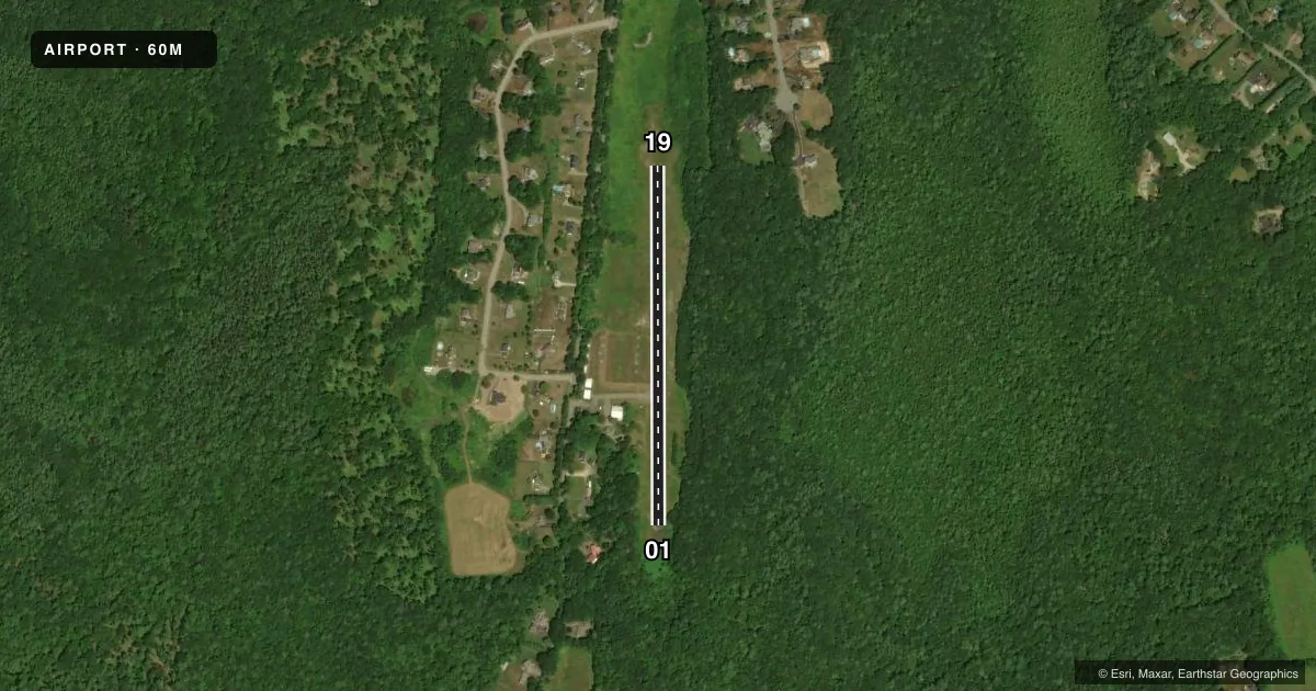
Airport sketch
Runways drawn to scale from FAA survey coordinates, rendered over satellite imagery. Not for navigation.
Approaches & charts
Services on the field
Fuel grades, oxygen, maintenance, ramp storage and lighting — as declared to the FAA by the airport operator.
Fuel & services
- Fuel
- Not available
- Oxygen (bottled)
- Not available
- Oxygen (bulk)
- Not available
- Airframe repair
- Not available
- Power plant repair
- Not available
Ramp & ground
- Transient storage
- Tie-down
- Landing fee
- No fee published
- Customs
- Not available
- Wind indicator
- Yes
- Segmented circle
- No
Fuel & FBOs
Cheapest 100LL and Jet A on the field and nearby. Always confirm with the FBO before taxi.
Airport notes
Surface conditions, obstructions, local procedures, lighting outages and other notes published with each FAA cycle.
General notes
- FOR CD CTC BRADLEY APCH AT 860-386-3597.
- CTC AMGR PPR FOR TSNT ACFT.
Other notes
- THIS AIRPORT HAS BEEN SURVEYED BY THE NATIONAL GEODETIC SURVEY.
- ARPT EXISTED PRIOR TO 1959.
- 01/19SFC COND POOR. RUTS & BUMPS ON RWY & TWY MAY CREATE A HAZ COND TO CERTAIN TYPES OF ACFT.
VFR map & nearby airports
VFR sectional. Tap any ICAO chip to open that airport.
Key facts · 60M
Answer card- ICAO
- 60M
- Name
- SPENCER
- Location
- SPENCER, MASSACHUSETTS
- Elevation
- 1,042.7 ft MSL
- Traffic pattern altitude
- 1,842.7 ft MSL (800 AGL)
- Control tower
- Non-towered (use CTAF)
- Total runways
- 1
- Longest runway
- 01/19 · 1,898 ft
- Published ILS approaches
- 0
- Published frequencies
- 2
- Magnetic variation
- 15°
- Current flight rules
- VFR
- Current wind
- 240° at 4 kt
- Favored runway now
- RWY 19
Spencer Airport (60M) is in Spencer, Massachusetts. The field elevation is 1,042.7 ft MSL. It has one runway, 01/19, which is 1,898 ft long. There is no control tower. CTAF and UNICOM are both 123.0.
Pattern altitude is 800 ft AGL. That puts the pattern at 1,842.7 ft MSL. No ILS approaches are published here, so plan with the current chart and weather in mind. The published remarks say the runway and taxiway surface is poor. Ruts and bumps may create a hazardous condition for some aircraft. That is the main operational item to brief before arrival.
The airport has no on-field FBOs listed. Contact the airport operator or the FBO directly by phone if you need current services before you go. The published remarks also say transient aircraft need prior permission from the airport manager. For clearance delivery, contact Bradley Approach at 860-386-3597. This field existed before 1959. If you are new to the airport, verify the current Chart Supplement for any updated local procedures before flying in.