METAR & TAF 6B6
6B6 does not publish a METAR.
Showing the nearest reporting station: KBED (LAURENCE G HANSCOM FLD) · 10.2 NM away. Conditions at 6B6 may differ.
METAR · KBED
Observed 12:51Z
KBED 271251Z 00000KT 10SM FEW100 18/11 A2985 RMK AO2 SLP119 T01780111 $
- Wind
- 000° @ 0 kt
- Visibility
- 10 SM
- Temp / Dew
- 18°C / 11°C
- Altimeter
- 29.85 inHg
- Clouds
- FEW
- Density alt
- 794 ft
- Ceiling
- Unlimited
- Rules
- VFR
Airport info & contacts
Manager on record, flight service, ARTCC, attendance schedule and pattern altitude — published by the FAA and refreshed every 28 days.
Location
- From city
- 2 NM N
- VFR sectional
- NEW YORK
- Pattern altitude
- 1,032 ft AGL · 1,312 ft MSL
- ARTCC
- ZBW · BOSTON
- NOTAM facility
- BDR (NOTAM-D)
Airport manager
- Name
- DONALD MC PHERSON
- Phone
- 978-897-3933
- Address
- 302 BOXBORO RD, STOW MA 01775
Flight service · Hours
- FSS BDR
- BRIDGEPORT1-800-WX-BRIEF
- Attendance
- 0900-1600
Frequencies
Tap any row to copy the frequency to your clipboard.
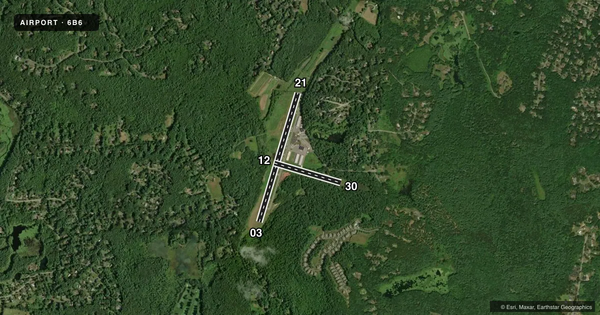
Runways & pattern
Full pagePattern entry · RWY 03
LEFT TRAFFIC| Runway | Heading (°M) | Length | Surface | Traffic |
|---|---|---|---|---|
| 03/21 | 1° / 181° | 3,110 ft | ASPH | Standard L |
| 12/30 | 90° / 270° | 1,600 ft | TURF | Standard L |
Runway end performance
| End | TORA | TODA | ASDA | LDA | VGSI | Approach lights | Obstruction |
|---|---|---|---|---|---|---|---|
| 03 | — | — | — | — | — | — | 156', trees, 2085' from thr, 0' R of cntrln, slope 13 |
| 21 | — | — | — | — | PAPI 2-box left(3.5°) | — | 98', trees, 1750' from thr, 150' R of cntrln, slope 15 |
| 12 | — | — | — | — | — | — | 30', trees, 300' from thr, 125' R of cntrln, slope 10 |
| 30 | — | — | — | — | — | — | 50', trees, 400' from thr, 125' R of cntrln, slope 8 |
Declared distances in feet. TORA = takeoff run available, TODA = takeoff distance, ASDA = accelerate-stop, LDA = landing distance.
Airport sketch
Runways drawn to scale from FAA survey coordinates, rendered over satellite imagery. Not for navigation.
Approaches & charts
Services on the field
Fuel grades, oxygen, maintenance, ramp storage and lighting — as declared to the FAA by the airport operator.
Fuel & services
- Fuel
- 100LL
- Oxygen (bottled)
- Not available
- Oxygen (bulk)
- Not available
- Airframe repair
- Major
- Power plant repair
- Major
- Other services
- INSTR,RNTL,SALES
Ramp & ground
- Transient storage
- Tie-down
- Hangar
- Landing fee
- No fee published
- Customs
- Not available
- Lighting schedule
- SEE RMK
- Beacon schedule
- SS-SR
- Beacon
- White / Green (civil land)(WG)
- Wind indicator
- Yes
- Segmented circle
- Yes
Fuel & FBOs
Cheapest 100LL and Jet A on the field and nearby. Always confirm with the FBO before taxi.
Airport notes
Surface conditions, obstructions, local procedures, lighting outages and other notes published with each FAA cycle.
General notes
- TPA FOR LGT ACFT 1032 FT AGL.
- BFR USING RWY 12/30 CALL AMGR TO DTRM RWY CONDS.
- TREE OBSTN IN APCH; PRIM & TRSN SFCS RWYS 03 & 12/30.
- NOISE ABATEMENT PROCS IN EFCT NTFY AMGR 978-897-3933 OF INTN TO OPR BTN 2300-0600.
- FOR CD CTC BOSTON APCH AT 603-594-5552.
Lighting notes
- ACTVT REIL RWY 21 - CTAF.
VFR map & nearby airports
VFR sectional. Tap any ICAO chip to open that airport.
Key facts · 6B6
Answer card- ICAO
- 6B6
- Name
- MINUTE MAN AIR FLD
- Location
- STOW, MASSACHUSETTS
- Elevation
- 280 ft MSL
- Traffic pattern altitude
- 1,312 ft MSL (1,032 AGL)
- Control tower
- Non-towered (use CTAF)
- Total runways
- 2
- Longest runway
- 03/21 · 3,110 ft
- Published ILS approaches
- 0
- Published frequencies
- 4
- Magnetic variation
- 16°
- Current flight rules
- VFR
- Current wind
- 000° at 0 kt
- Favored runway now
- –
Minute Man Air Fld is in Stow, Massachusetts. Field elevation is 280 ft MSL. It has two runways. The longest is 03/21 at 3,110 ft of asphalt. Runway 12/30 is 1,600 ft of turf. There is no control tower. Pattern altitude for light aircraft is 1,312 ft MSL, which is 1,032 ft AGL.
No ILS approaches are published here. Boston Approach handles the area frequencies listed for approach and departure. For clearance delivery, contact Boston Approach at 603-594-5552. Stow Aviation Services is on the field. It carries 100LL. Runway 21 has runway end identifier lights activated on CTAF. The published remarks also call out tree obstructions in the approach area near the primary and transitional surfaces for runways 03 and 12/30.
This is a field where the details matter. Noise abatement procedures are in effect. If you plan to operate between 2300 and 0600, notify the airport manager first. Before using runway 12/30, call the airport manager to check runway conditions. If you are new to the airport, plan for a close look at the turf strip, the tree environment and the pattern altitude before you arrive.