METAR & TAF KASH
Current METAR
Observed 08:56Z
KASH 270856Z AUTO 00000KT 10SM CLR 11/11 A2985 RMK AO2 SLP106 T01060106 56004
- Wind
- 000° @ 0 kt
- Visibility
- 10 SM
- Temp / Dew
- 11°C / 11°C
- Altimeter
- 29.85 inHg
- Clouds
- CLR
- Density alt
- -145 ft
- Ceiling
- Unlimited
- Rules
- VFR
Airport info & contacts
Manager on record, flight service, ARTCC, attendance schedule and pattern altitude — published by the FAA and refreshed every 28 days.
Location
- From city
- 3 NM NW
- VFR sectional
- NEW YORK
- ARTCC
- ZBW · BOSTON
- NOTAM facility
- ASH (NOTAM-D)
Airport manager
- Name
- CHRIS LYNCH
- Phone
- 603-882-0661
- Address
- 93 PERIMETER RD, NASHUA NH 03063
Flight service · Hours
- FSS BGR
- BANGOR1-800-WX-BRIEF
- Attendance
- 0700-2100
Frequencies
Tap any row to copy the frequency to your clipboard.
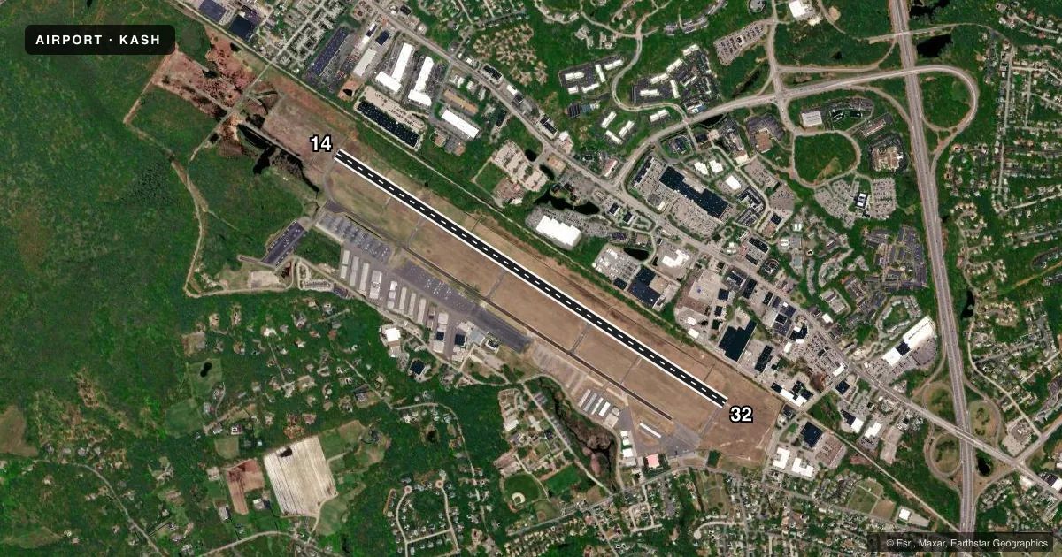
Runways & pattern
Full pagePattern entry · RWY 14
LEFT TRAFFICRunway end performance
| End | TORA | TODA | ASDA | LDA | VGSI | Approach lights | Obstruction |
|---|---|---|---|---|---|---|---|
| 14 | 6,000' | 6,000' | 5,650' | 5,650' | PAPI 4-box right(3°) | MALSR | 30', pole, 1487' from thr, 370' R of cntrln, slope 42 |
| 32 | 6,000' | 6,000' | 6,000' | 5,650' | PAPI 4-box left(3°) | — | 63', tree, 1351' from thr, 287' R of cntrln, slope 18 |
Declared distances in feet. TORA = takeoff run available, TODA = takeoff distance, ASDA = accelerate-stop, LDA = landing distance.
Airport sketch
Runways drawn to scale from FAA survey coordinates, rendered over satellite imagery. Not for navigation.
Approaches & charts
ILS · 1
Services on the field
Fuel grades, oxygen, maintenance, ramp storage and lighting — as declared to the FAA by the airport operator.
Fuel & services
- Fuel
- 100LLA1+
- Oxygen (bottled)
- HIGH/LOW
- Oxygen (bulk)
- HIGH/LOW
- Airframe repair
- Major
- Power plant repair
- Major
- Other services
- CHTR,INSTR,RNTL,SALES
Ramp & ground
- Transient storage
- Tie-down
- Hangar
- Landing fee
- No fee published
- Customs
- Not available
- Lighting schedule
- SEE RMK
- Beacon schedule
- SS-SR
- Beacon
- White / Green (civil land)(WG)
- Wind indicator
- Lighted
Fuel & FBOs
Cheapest 100LL and Jet A on the field and nearby. Always confirm with the FBO before taxi.
Airport notes
Surface conditions, obstructions, local procedures, lighting outages and other notes published with each FAA cycle.
General notes
- ARPT HAS VOLUNTARY NOISE ABATEMENT PROCS. CTC AMGR FOR DETAILS.
- MIGRATORY BIRDS & WILDLIFE ON & INVOF ARPT.
- RAMP BTN TWY D & TWY E CLSD TO ACFT WITH WINGSPAN GTR THAN 48 FT UNLESS AUZD BY ATCT.
Lighting notes
- WHEN TWR CLSD ACTVT MALSR RWY 14; REIL RWY 32; PAPI RWY 14; HIRL RWY 14/32 - CTAF.
Approach & departure obstructions
- 14TREES LCTD ALG RAIL LN N OF RWY.
- 32APCH SLOPE 44:1 TO DTHR.
Other notes
- FOR ACFT OVR 12500 LBS, FEE PER 1000 LBS.
VFR map & nearby airports
VFR sectional. Tap any ICAO chip to open that airport.
Key facts · KASH
Answer card- ICAO
- KASH
- Name
- BOIRE FLD
- Location
- NASHUA, NEW HAMPSHIRE
- Elevation
- 200.4 ft MSL
- Traffic pattern altitude
- 1,200.4 ft MSL (1,000 AGL)
- Control tower
- Towered · 0700-2100
- Total runways
- 1
- Longest runway
- 14/32 · 6,000 ft
- Published ILS approaches
- 1
- Published frequencies
- 8
- Magnetic variation
- 16°
- Current flight rules
- VFR
- Current wind
- 000° at 0 kt
- Favored runway now
- –
Boire Field sits in Nashua, New Hampshire. Field elevation is 200.4 ft MSL. The airport has one runway. Runway 14/32 is 6,000 ft long with asphalt pavement. Tower service is published from 0700 to 2100. The field has one ILS approach. It serves runway 14.
Pattern altitude is not published. Use 1,000 ft AGL for light piston operations unless the current Chart Supplement or ATC gives you something different. Infinity Aviation Services is on the field. It carries 100LL, Jet A and Jet A Prist. Call them at (603) 598-4526 for current services.
This is a busy Nashua-area field. Expect local traffic and voluntary noise abatement procedures. The airport also notes birds and wildlife in the area. There is a ramp restriction between taxiways D and E for aircraft with wingspans over 48 ft unless tower authorizes it. Trees are noted along the railroad lane north of runway 14. Runway 32 has a displaced-threshold approach slope note. When the tower is closed, lighting is activated on CTAF for runway 14, runway 32, the MALSR on 14, the REIL on 32, the PAPI on 14 and the high-intensity runway lights.