METAR & TAF KBED
Current METAR
Observed 14:51Z
KBED 271451Z 00000KT 10SM CLR 24/10 A2984 RMK AO2 SLP116 T02440100 58001 $
- Wind
- 000° @ 0 kt
- Visibility
- 10 SM
- Temp / Dew
- 24°C / 10°C
- Altimeter
- 29.84 inHg
- Clouds
- CLR
- Density alt
- 1,343 ft
- Ceiling
- Unlimited
- Rules
- VFR
Airport info & contacts
Manager on record, flight service, ARTCC, attendance schedule and pattern altitude — published by the FAA and refreshed every 28 days.
Location
- From city
- 0 NM NE
- VFR sectional
- NEW YORK
- ARTCC
- ZBW · BOSTON
- NOTAM facility
- BED (NOTAM-D)
Airport manager
- Name
- CHRISTOPHER J. WILLENBORG
- Phone
- 617-212-6592
- Address
- MASSPORT, 200 HANSCOM DR, BEDFORD MA 01730
Flight service · Hours
- FSS BDR
- BRIDGEPORT1-800-WX-BRIEF
- Attendance
- ALL
Frequencies
Tap any row to copy the frequency to your clipboard.
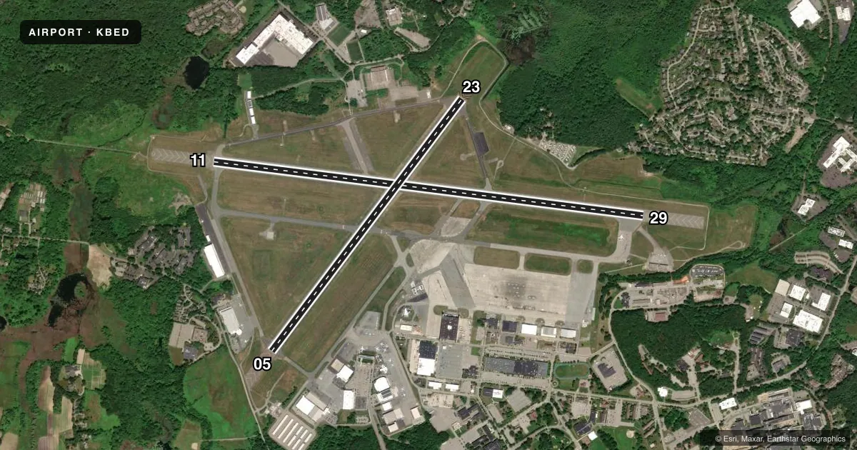
Runways & pattern
Full pagePattern entry · RWY 11
LEFT TRAFFIC| Runway | Heading (°M) | Length | Surface | Traffic |
|---|---|---|---|---|
| 11/29 | 81° / 261° | 7,011 ft | ASPH | Standard L |
| 05/23 | 21° / 201° | 5,107 ft | ASPH | Standard L |
Runway end performance
| End | TORA | TODA | ASDA | LDA | VGSI | Approach lights | Obstruction |
|---|---|---|---|---|---|---|---|
| 11 | 7,011' | 7,011' | 7,011' | 7,011' | PAPI 4-box left(3°) | MALSR | 120', hill, 1050' from thr, 734' R of cntrln, slope 34 |
| 29 | 7,011' | 7,011' | 7,011' | 7,011' | PAPI 4-box right(3°) | MALSR | — |
| 05 | 5,107' | 5,107' | 5,107' | 5,107' | PAPI 4-box left(3.5°) | — | — |
| 23 | 5,107' | 5,107' | 5,107' | 5,107' | PAPI 4-box right(3.2°) | — | — |
Declared distances in feet. TORA = takeoff run available, TODA = takeoff distance, ASDA = accelerate-stop, LDA = landing distance.
Airport sketch
Runways drawn to scale from FAA survey coordinates, rendered over satellite imagery. Not for navigation.
Approaches & charts
ILS · 2
Services on the field
Fuel grades, oxygen, maintenance, ramp storage and lighting — as declared to the FAA by the airport operator.
Fuel & services
- Fuel
- 100LLA
- Oxygen (bottled)
- HIGH/LOW
- Oxygen (bulk)
- HIGH/LOW
- Airframe repair
- Major
- Power plant repair
- Major
- Other services
- AFRT,AMB,AVNCS,CHTR,INSTR,RNTL,SALES
Ramp & ground
- Transient storage
- Tie-down
- Hangar
- Landing fee
- Yes
- Customs
- Not available
- Lighting schedule
- SEE RMK
- Beacon schedule
- SS-SR
- Beacon
- White / Green (civil land)(WG)
- Wind indicator
- Lighted
- Segmented circle
- Yes
Fuel & FBOs
Cheapest 100LL and Jet A on the field and nearby. Always confirm with the FBO before taxi.
Airport notes
Surface conditions, obstructions, local procedures, lighting outages and other notes published with each FAA cycle.
General notes
- PPR FOR ALL ACFT CARRYING XPLOS CALL 617-212-6592.
- NO PLAS/TGLS FOR ACFT 12500 LBS & OVR.
- NOISE ABATEMENT PROCS IN EFCT - HELS OPERG WI CNTLD ASP ARE RQRD TO MNTN HIST PSBL ALT.
- SUPPORT: OPR 1200-0400Z++ MON-FRI, 1300-1900Z++ SAT & SUN, CLSD HOL. CTC BASE OPS PRIOR TO 1700Z++ FRI FOR OT SUPPORT.
- BIRDS & WILDLIFE ON & INVOF ARPT.
- BE ALERT FOR SML ACFT PARKED ON RAMPS.
- (A23) RWY 29 RIGHT TFC ACFT OVR 12500 LBS.
- TWY C, F, J, N, R, S, T, TWY M SOUTH OF TWY E & TWY G BTN RWY 11/29 & RWY 05/23 CLSD TO ACFT GTR THAN 118 FT WINGSPAN. TWY R CLSD TO ACR OPS-GA USE ONLY.
- NO PLAS/TGLS FOR ACFT UNDER 12500 LBS BTN 2300-0700.
- SVC-TRAN ALERT: OPR 1200-0400Z++ WKD; 1400-2200Z++ SUN; PPR OT AND HOL DSN 845-5589/5592. DE-ICING AVBL FR VENDOR.
- AF: PPR ALL MIL ACFT, PAX MNFST REQ ALL INBD PAX, CTC BASE OPS DSN 845-5589/5592, C781-225-5589/5592.
- AF: COMD POST DSN 845-6960/6961, C781-225-6960/6961.
- VOLUNTARY NOISE ABATEMENT PROCS IN EFCT CTC AMGR 617-212-6592. NOISE SENSITIVE HISTORIC AREA S OF ARPT; FOR RWY 23 DEP CONT RWY HDG TO 1000 FT AGL, TURNING CROSSWIND OVR RTE 2.
- SERVICE: MIL ACFT MUST ARNG FOR PRKG ON EAST RAMP WITH TRAN ALERT OR VENDOR.
- TWY R1, R2 CLSD TO ACFT GTR THAN 49 FT WINGSPAN.
- APU-GPU OPS LTD TO MAX OF 30 MINS.
Lighting notes
- ACTVT MALSR RWY 11 & 29; REIL RWY 05 & 23; HIRL RWY 11/29; MIRL RWY 05/23; TWY LGTS - 118.5.
Runway surface & condition
- 05/23PCR VALUE: 770/F/D/W/T
- 11/29PCR VALUE: 950/F/D/W/T
Other notes
- CLSD TO PART 121 ACR OPS WITH OVR 60 SEATS EXCP 24 HR PPR CALL 781-869-8000.
- SURCHARGE FOR EACH LDG & DEP 2300-0700. COML & TSNT LDG FEE.
- 1000 FT AGL FIXED WING; 1500 FT AGL TURBOJET; 1800 FT AGL HEAVY JET ACFT.
VFR map & nearby airports
VFR sectional. Tap any ICAO chip to open that airport.
Key facts · KBED
Answer card- ICAO
- KBED
- Name
- LAURENCE G HANSCOM FLD
- Location
- BEDFORD, MASSACHUSETTS
- Elevation
- 132 ft MSL
- Traffic pattern altitude
- 1,132 ft MSL (1,000 AGL)
- Control tower
- Towered · 0700-2300
- Total runways
- 2
- Longest runway
- 11/29 · 7,011 ft
- Published ILS approaches
- 2
- Published frequencies
- 11
- Magnetic variation
- 16°
- Current flight rules
- VFR
- Current wind
- 000° at 0 kt
- Favored runway now
- –
Laurence G Hanscom Fld sits in Bedford, Massachusetts, near the Boston metro area. Field elevation is 132 ft MSL. The airport has 2 asphalt runways. The longest is 11/29 at 7,011 ft. Tower is open 0700-2300. Two ILS approaches are published for runway ends 11 and 29. Traffic pattern altitude is 1,000 ft AGL for fixed-wing aircraft. That puts the light aircraft pattern at 1,132 ft MSL.
On the field you will find Signature Aviation, Atlantic Aviation and Jet Aviation Boston. They carry AVGAS 100LL and Jet A. Atlantic Aviation and Jet Aviation Boston also carry Jet A Prist. Published remarks call out active noise abatement. There is also a noise sensitive historic area south of the airport. For runway 23 departures, plan to continue runway heading to 1,000 ft AGL before turning crosswind over Route 2.
This is a busy controlled field with military and civilian activity. Some taxiways are closed to aircraft over certain wingspans, so large aircraft should review the current Chart Supplement before arrival. Birds and wildlife are also reported on and near the airport. If you are planning a night arrival, note that there is a surcharge for landings and departures between 2300 and 0700. Check the current FAA Chart Supplement for any current restrictions before flying in.