METAR & TAF KBOS
Current METAR
Observed 04:54Z
KBOS 280454Z 18006KT 10SM FEW250 20/18 A2978 RMK AO2 SLP083 T02000178 402500150 $
- Wind
- 180° @ 6 kt
- Visibility
- 10 SM
- Temp / Dew
- 20°C / 18°C
- Altimeter
- 29.78 inHg
- Clouds
- FEW
- Density alt
- 797 ft
- Ceiling
- Unlimited
- Rules
- VFR
Airport info & contacts
Manager on record, flight service, ARTCC, attendance schedule and pattern altitude — published by the FAA and refreshed every 28 days.
Location
- From city
- 1 NM E
- VFR sectional
- NEW YORK
- ARTCC
- ZBW · BOSTON
- NOTAM facility
- BOS (NOTAM-D)
Airport manager
- Name
- EDWARD FRENI
- Phone
- 617-567-5400
- Address
- LOGAN INTERNATIONAL AIRPORT, HARBORSIDE DR STE 200S, EAST BOSTON MA 02128-2909
Flight service · Hours
- FSS BDR
- BRIDGEPORT1-800-WX-BRIEF
- Attendance
- ALL
Frequencies
Tap any row to copy the frequency to your clipboard.
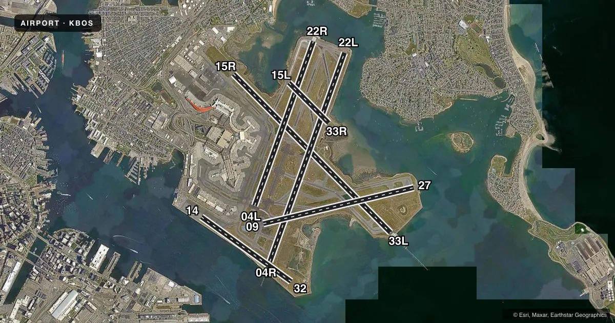
Runways & pattern
Full pagePattern entry · RWY 22L
LEFT TRAFFIC| Runway | Heading (°M) | Length | Surface | Traffic |
|---|---|---|---|---|
| 15R/33L | 120° / 300° | 10,083 ft | ASPH | Standard L |
| 04R/22LFavored | 5° / 185° | 10,006 ft | ASPH | Standard L |
| 04L/22R | 5° / 185° | 7,864 ft | ASPH | Standard L |
| 09/27 | 62° / 242° | 7,001 ft | ASPH | Standard L |
| 14/32 | 110° / 290° | 5,000 ft | ASPH | Standard L |
| 15L/33R | 120° / 300° | 2,557 ft | ASPH | Standard L |
Runway end performance
| End | TORA | TODA | ASDA | LDA | VGSI | Approach lights | Obstruction |
|---|---|---|---|---|---|---|---|
| 15R | 10,083' | 10,083' | 10,083' | 9,202' | PAPI 4-box left(3°) | MALSR | 62', trees, 3040' from thr, 140' R of cntrln, slope 45 |
| 33L | 10,083' | 10,083' | 10,083' | 10,083' | PAPI 4-box right(3°) | ALSF2 | 160', boat, 5075' from thr, slope 30 |
| 04R | 10,006' | 10,006' | 10,006' | 8,851' | PAPI 4-box left(3°) | ALSF2 | 157', boat, 1550' from thr, slope 8 |
| 22L | 10,006' | 10,006' | 10,006' | 8,806' | PAPI 4-box right(3°) | MALSF | 45', boat, 525' from thr, slope 7 |
| 04L | 7,864' | 7,864' | 7,864' | 7,864' | PAPI 4-box left(3.1°) | — | 161', boat, 3250' from thr, slope 18 |
| 22R | 7,864' | 7,864' | 7,864' | 7,046' | PAPI 4-box left(3°) | — | 44', boat, 670' from thr, slope 10 |
| 09 | 7,001' | 7,001' | 7,001' | 7,001' | — | — | 158', boat, 2050' from thr, slope 11 |
| 27 | 7,001' | 7,001' | 7,001' | 7,001' | PAPI 4-box left(3°) | — | 45', boat, 500' from thr, slope 6 |
| 14 | 5,000' | 5,000' | 5,000' | — | — | — | 174', bldg, 1364' from thr, 70' R of cntrln |
| 32 | — | — | — | 5,000' | PAPI 4-box left(3°) | — | — |
| 15L | 2,557' | 2,557' | 2,557' | 2,557' | — | — | — |
| 33R | 2,557' | 2,557' | 2,557' | 2,557' | PAPI 4-box right(3°) | — | — |
Declared distances in feet. TORA = takeoff run available, TODA = takeoff distance, ASDA = accelerate-stop, LDA = landing distance.
Airport sketch
Runways drawn to scale from FAA survey coordinates, rendered over satellite imagery. Not for navigation.
Approaches & charts
ILS · 5
Services on the field
Fuel grades, oxygen, maintenance, ramp storage and lighting — as declared to the FAA by the airport operator.
Fuel & services
- Fuel
- 100LLA
- Oxygen (bottled)
- HIGH/LOW
- Oxygen (bulk)
- HIGH/LOW
- Airframe repair
- Major
- Power plant repair
- Major
- Other services
- AFRT,CARGO,CHTR
Ramp & ground
- Transient storage
- Not published
- Landing fee
- Yes
- Customs
- Not available
- Beacon schedule
- SS-SR
- Beacon
- White / Green (civil land)(WG)
- Wind indicator
- Lighted
- Segmented circle
- No
Fuel & FBOs
Cheapest 100LL and Jet A on the field and nearby. Always confirm with the FBO before taxi.
Airport notes
Surface conditions, obstructions, local procedures, lighting outages and other notes published with each FAA cycle.
General notes
- BIRDS ON & INVOF ARPT.
- NO RON PARKING FOR NON-TENANT CHARTER AIRCRAFT WITHOUT PRIOR MASSPORT PERMISSION.
- TERMINAL E; NORTH & SOUTH CARGO ARRIVALS CTC MASSPORT GATE CONTROL ON FREQ 131.1 BEFORE ENTERING/DEPARTING RAMP AREA.
- NMRS CRANES ON AND INVOF ARPT.
- RWY 14/32 UNIDIRECTIONAL; NO LDGS RWY 14; NO TKOFS RWY 32.
- PILOTS SHOULD COMPLETE ALL CALCULATIONS PRIOR TO PUSHBACK FROM GATE.
- RWY STATUS LGTS IN OPN.
- FOR NOISE ABATEMENT, RWY 15R IS PREFERRED FOR TKOF, RWY 33L IS PREFERRED FOR LDG. FOR MORE INFO ON NOISE ABATEMENT PROCS CALL 617-561-3333.
- THE USE OF THE RNAV SIDS AT BOSTON LOGAN ARE CRITICAL TO RDCG NOISE AND ACHIEVING OUR FLY QUIET GOALS. MASSPORT AND THE FAA ENCOURAGE PILOTS TO USE PUBLD RNAV FLIGHT PROCS AT BOSTON LOGAN ARPT WHENEVER POSS. ALL ACFT THAT HAVE REQD ALTS ABV 10,000 FT SHOULD BE FILING RNAV SIDS WITH FAA ATC. CTC MASSPORT'S NOISE ABATEMENT OFC AT 617-561-3333 WITH ANY QNS.
Runway surface & condition
- 04L/22RPCR VALUE: 800/F/C/X/T
- 04R/22LPCR VALUE: 830/F/C/X/T
- 09/27PCR VALUE: 810/F/C/X/T
- 14/32PCR VALUE: 780/F/C/X/T
- 15L/33RPCR VALUE: 850/F/C/X/T
- 15R/33LPCR VALUE: 800/F/C/X/T
Approach & departure obstructions
- 14AVBL FOR DEPARTURE ONLY.
- 22LUNUSBL BYD 7 DEGS LEFT OF CNTRLN.
- 04RAPCH RATIO 17:1 FROM DSPLCD THR; 43:1 WHEN CHANNEL IS CLEAR.
- 14APPROACHES TO RWY 14 NOT AUTHORIZED.
- 15RAPCH RATIO 50:1 FROM DSPLCD THR.
- 22LAPCH RATIO 38:1 FROM DSPLCD THR.
- 22RAPCH RATIO 33:1 FROM DSPLCD THR; 50:1 TO THR WHEN CHANNEL IS CLEAR.
Arresting gear
- 04L_EMASENGINEERING MATERIALS ARRESTING SYSTEM (EMAS) 190 FT IN LENGTH BY 170 FT IN WIDTH LCTD AT DER 04L.
- 15R_EMASENGINEERED MATERIALS ARRESTING SYSTEM (EMAS) 158 FT IN LENGTH BY 170 FT IN WIDTH LCTD AT DER 15R.
Other notes
- PRVDD THE DESIGNATION OF A MOVEMENT AREA ASSOCIATED WITH THE RELCTN IS COORDINATED WITH & DESIGNATED BY BOSTON ATCT; APPROPRIATE HOLD LINES ESTABLISHED & MARKED FOR SERVICE VEHICLE MOVEMENT & TAXILANES; RELCTN MARKED IN ACCORDANCE WITH FAA ADVISORY CIRCULAR/5930-2.
VFR map & nearby airports
VFR sectional. Tap any ICAO chip to open that airport.
Key facts · KBOS
Answer card- ICAO
- KBOS
- Name
- GENERAL EDWARD LAWRENCE LOGAN INTL
- Location
- BOSTON, MASSACHUSETTS
- Elevation
- 19.1 ft MSL
- Traffic pattern altitude
- 1,019.1 ft MSL (1,000 AGL)
- Control tower
- Towered · 24
- Total runways
- 6
- Longest runway
- 15R/33L · 10,083 ft
- Published ILS approaches
- 5
- Published frequencies
- 20
- Magnetic variation
- 15°
- Current flight rules
- VFR
- Current wind
- 180° at 6 kt
- Favored runway now
- RWY 22L
General Edward Lawrence Logan Intl is in Boston, Massachusetts. The field elevation is 19.1 ft MSL. KBOS has 6 asphalt runways. The longest is 10,083 ft. The tower is open 24 hours. Five ILS approaches are published. Pattern altitude is not published in the facts, so verify the current Chart Supplement before you fly. For light piston traffic, use the standard 1,000 ft AGL pattern only if that matches current published guidance.
Signature Aviation is on the field. It carries 100LL and Jet A. Call them at (617) 561-2500 for current services. Boston Logan is a busy Class B environment. Expect close sequencing and strict compliance with ATC instructions. Massport also publishes noise abatement guidance. Runway 15R is preferred for takeoff. Runway 33L is preferred for landing. RNAV departures are encouraged when possible to help reduce noise. There is no ramp overnight parking for non-tenant charter aircraft without prior Massport permission. Runway status lights are in operation. EMAS is installed at the departure ends of 04L and 15R. If you are planning a first arrival here, brief the runway layout carefully and review the current Chart Supplement before departure.