METAR & TAF KLWM
Current METAR
Observed 14:54Z
KLWM 271454Z 06004KT 10SM CLR 24/10 A2987 RMK AO2 SLP114 T02440100 58001
- Wind
- 060° @ 4 kt
- Visibility
- 10 SM
- Temp / Dew
- 24°C / 10°C
- Altimeter
- 29.87 inHg
- Clouds
- CLR
- Density alt
- 1,325 ft
- Ceiling
- Unlimited
- Rules
- VFR
Airport info & contacts
Manager on record, flight service, ARTCC, attendance schedule and pattern altitude — published by the FAA and refreshed every 28 days.
Location
- From city
- 2 NM E
- VFR sectional
- NEW YORK
- ARTCC
- ZBW · BOSTON
- NOTAM facility
- LWM (NOTAM-D)
Airport manager
- Name
- FRANCISCO A. URENA
- Phone
- 978-794-5880
- Address
- 492 SUTTON ST, NO. ANDOVER MA 01845
Flight service · Hours
- FSS BDR
- BRIDGEPORT1-800-WX-BRIEF
- Attendance
- 0700-2200
Frequencies
Tap any row to copy the frequency to your clipboard.
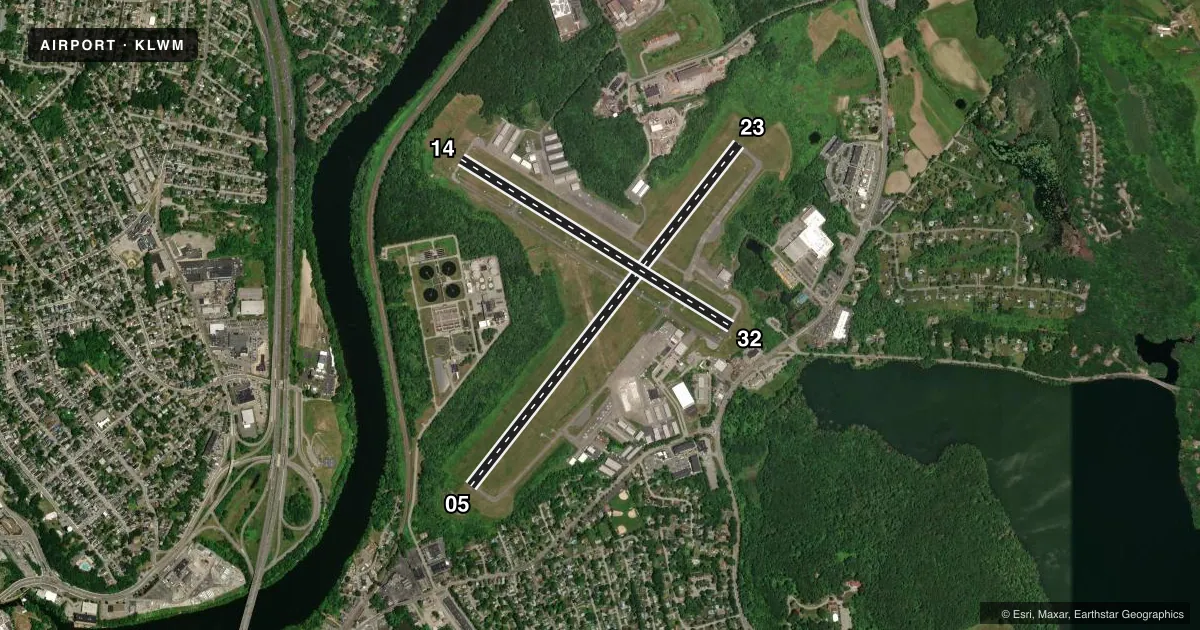
Runways & pattern
Full pagePattern entry · RWY 05
LEFT TRAFFIC| Runway | Heading (°M) | Length | Surface | Traffic |
|---|---|---|---|---|
| 05/23Favored | 23° / 203° | 5,001 ft | ASPH | Standard L |
| 14/32 | 107° / 287° | 3,654 ft | ASPH | Standard L |
Runway end performance
| End | TORA | TODA | ASDA | LDA | VGSI | Approach lights | Obstruction |
|---|---|---|---|---|---|---|---|
| 05 | — | — | — | — | PAPI 4-box right(3°) | — | — |
| 23 | — | — | — | — | PAPI 4-box left(3.7°) | — | 13', trees, 650' from thr, 0' R of cntrln, slope 34 |
| 32 | — | — | — | — | PAPI 4-box left(4°) | — | 7', trees, 300' from thr, 125' R of cntrln, slope 14 |
Declared distances in feet. TORA = takeoff run available, TODA = takeoff distance, ASDA = accelerate-stop, LDA = landing distance.
Airport sketch
Runways drawn to scale from FAA survey coordinates, rendered over satellite imagery. Not for navigation.
Approaches & charts
ILS · 1
Services on the field
Fuel grades, oxygen, maintenance, ramp storage and lighting — as declared to the FAA by the airport operator.
Fuel & services
- Fuel
- 100LLAA+
- Oxygen (bottled)
- Not available
- Oxygen (bulk)
- Not available
- Airframe repair
- Major
- Power plant repair
- Major
- Other services
- AMB,CARGO,INSTR,RNTL,SALES,SURV
Ramp & ground
- Transient storage
- Tie-down
- Hangar
- Landing fee
- Yes
- Customs
- Not available
- Lighting schedule
- SEE RMK
- Beacon schedule
- SS-SR
- Beacon
- White / Green (civil land)(WG)
- Wind indicator
- Yes
- Segmented circle
- No
Fuel & FBOs
Cheapest 100LL and Jet A on the field and nearby. Always confirm with the FBO before taxi.
Airport notes
Surface conditions, obstructions, local procedures, lighting outages and other notes published with each FAA cycle.
General notes
- HILL 5400 FT SE & STANDPIPE 7200 FT NE; LGTD.
- LGTD STACK 296 FT MSL 1/2 MI NW AER 23.
- CLSD TFC PAT, INITIATE TURN-OUT AT 700 FT AGL.
- USE RSNBL EFFORTS TO MNTN MANUFACTURER'S RCMDD BEST ROC.
- WILDLIFE ON & INVOF ARPT.
Lighting notes
- ACTVT REIL RWY 05, 23, 14 & 32; PAPI RWY 05, 23 & 32; HIRL RWY 05/23; MIRL RWY 14/32 - CTAF.
Approach & departure obstructions
- 32APCH RATIO 50:1 TO DTHR.
Other notes
- ESTABD PRIOR TO 1959.
- LNDG FEE FOR ACFT REGISTERED TO CORPORATION ONLY.
VFR map & nearby airports
VFR sectional. Tap any ICAO chip to open that airport.
Key facts · KLWM
Answer card- ICAO
- KLWM
- Name
- LAWRENCE MUNI
- Location
- LAWRENCE, MASSACHUSETTS
- Elevation
- 147.6 ft MSL
- Traffic pattern altitude
- 1,147.6 ft MSL (1,000 AGL)
- Control tower
- Towered · 0700-2200
- Total runways
- 2
- Longest runway
- 05/23 · 5,001 ft
- Published ILS approaches
- 1
- Published frequencies
- 9
- Magnetic variation
- 15°
- Current flight rules
- VFR
- Current wind
- 060° at 4 kt
- Favored runway now
- RWY 05
Lawrence Muni sits in Lawrence, Massachusetts. Field elevation is 147.6 ft MSL. The airport has two asphalt runways. The longest is runway 05/23 at 5,001 ft. The tower is open daily from 0700 to 2200. One ILS approach is published for runway 05.
Pattern altitude is not published. Use the standard 1,000 ft AGL for light piston traffic unless ATC or the Chart Supplement says otherwise. The field uses CTAF for communications outside tower hours. Published remarks call out runway lighting on both runways. Runway 05/23 has high intensity lights. Runway 14/32 has medium intensity lights. REILs are available on both ends of both runways. PAPI is available on runway 05, runway 23 and runway 32.
On the field you will find Lawrence Airmotive with 100LL. Eagle East Aviation carries 100LL and Jet A Prist. Falcon Air carries 100LL and Jet A. Lawrence Jet Center carries Jet A. Wildlife is reported on and near the airport. The published remarks also note a closed traffic pattern with turns outbound at 700 ft AGL. There is a lighted stack about one-half mile northwest of the airport reference point for runway 23. A hill southeast and a standpipe northeast are also lighted. Check the current Chart Supplement for any noise or local operating notes before you go.