METAR & TAF 2B2
2B2 does not publish a METAR.
Showing the nearest reporting station: KBVY (BEVERLY RGNL) · 13.1 NM away. Conditions at 2B2 may differ.
METAR · KBVY
Observed 22:53Z
KBVY 242253Z 30005KT 10SM FEW070 26/13 A2988 RMK AO2 SLP111 T02560128
- Wind
- 300° @ 5 kt
- Visibility
- 10 SM
- Temp / Dew
- 26°C / 13°C
- Altimeter
- 29.88 inHg
- Clouds
- FEW
- Density alt
- 1,383 ft
- Ceiling
- Unlimited
- Rules
- VFR
Airport info & contacts
Manager on record, flight service, ARTCC, attendance schedule and pattern altitude — published by the FAA and refreshed every 28 days.
Location
- From city
- 1 NM SE
- VFR sectional
- NEW YORK
- ARTCC
- ZBW · BOSTON
- NOTAM facility
- BDR (NOTAM-D)
Airport manager
- Name
- STEPHEN NOYES/RICHARD COPITHORNE
- Phone
- 978-463-4222
- Address
- 24 PLUM ISLAND TURNPIKE, NEWBURY MA 01951
Flight service · Hours
- FSS BDR
- BRIDGEPORT1-800-WX-BRIEF
- Attendance
- APR-SEP · 0800-1800
- OCT-MAR · IREG · IREG
Frequencies
Tap any row to copy the frequency to your clipboard.
Runways & pattern
Full pagePattern entry · RWY 28
LEFT TRAFFICRunway end performance
| End | TORA | TODA | ASDA | LDA | VGSI | Approach lights | Obstruction |
|---|---|---|---|---|---|---|---|
| 10 | — | — | — | — | — | — | 100', trees, 500' from thr, 100' R of cntrln, slope 3 |
| 28 | — | — | — | — | — | — | 8', fence, 300' from thr, 55' R of cntrln, slope 10 |
Declared distances in feet. TORA = takeoff run available, TODA = takeoff distance, ASDA = accelerate-stop, LDA = landing distance.
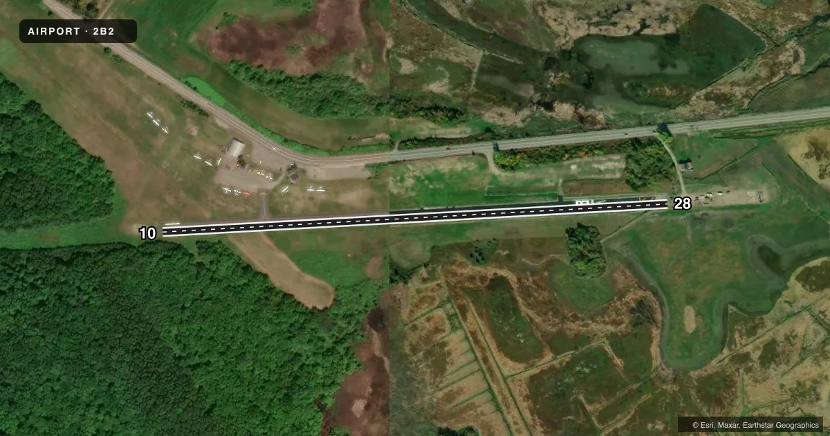
Airport sketch
Runways drawn to scale from FAA survey coordinates, rendered over satellite imagery. Not for navigation.
Approaches & charts
Services on the field
Fuel grades, oxygen, maintenance, ramp storage and lighting — as declared to the FAA by the airport operator.
Fuel & services
- Fuel
- 100LL
- Oxygen (bottled)
- Not available
- Oxygen (bulk)
- Not available
- Airframe repair
- Major
- Power plant repair
- Major
- Other services
- INSTR,RNTL,TOW
Ramp & ground
- Transient storage
- Tie-down
- Landing fee
- No fee published
- Customs
- Not available
- Wind indicator
- Yes
- Segmented circle
- No
Fuel & FBOs
Cheapest 100LL and Jet A on the field and nearby. Always confirm with the FBO before taxi.
Airport notes
Surface conditions, obstructions, local procedures, lighting outages and other notes published with each FAA cycle.
General notes
- NO TGLS ALLOWED.
- WILDLIFE INVOF ARPT.
- FOR CD CTC BOSTON APCH AT 603-594-5552.
- CTC MGR FOR ALL ARPT USE REQS. OWNER DOES NOT OVERSEE OPS.
Approach & departure obstructions
- 284 FT UNLIT FENCE CROSSES RWY. VEHICLE AND EQUIP INVOF RWY.
Other notes
- ESTAB PRIOR 1959
- HNE, HISTORIC NEW ENGLAND INC.
VFR map & nearby airports
VFR sectional. Tap any ICAO chip to open that airport.
Key facts · 2B2
Answer card- ICAO
- 2B2
- Name
- PLUM ISLAND
- Location
- NEWBURYPORT, MASSACHUSETTS
- Elevation
- 11 ft MSL
- Traffic pattern altitude
- 1,011 ft MSL (1,000 AGL)
- Control tower
- Non-towered (use CTAF)
- Total runways
- 1
- Longest runway
- 10/28 · 2,105 ft
- Published ILS approaches
- 0
- Published frequencies
- 4
- Magnetic variation
- 16°
- Current flight rules
- VFR
- Current wind
- 300° at 5 kt
- Favored runway now
- RWY 28
Plum Island Airport sits in Newburyport, Massachusetts. Field elevation is 11 ft MSL. It has one runway, 10/28, which is 2,105 ft long with asphalt pavement. The field is not towered. CTAF and UNICOM are both 123.0. Boston Approach handles clearance delivery on 603-594-5552. No ILS approaches are published here.
Pattern altitude is not published. Use 1,000 ft AGL for light piston operations unless the current Chart Supplement or the airport manager gives you something different. The on-field FBO is Plum Island Aerodrome. It carries 100LL. Call (978) 463-4222 before arrival if you need current field status or service details.
A few local items matter here. No touch-and-go landings are allowed. A 4-foot unlit fence crosses runway 28. Vehicle and equipment may also be in the runway area. Wildlife is in the vicinity. This is a low-elevation coastal field with limited runway length, so plan your performance with care. The airport is owned by Historic New England Incorporated. Contact the manager for all airport use requests. The owner does not oversee operations.