METAR & TAF KDAW
Current METAR
Observed 12:51Z
KDAW 271251Z AUTO 00000KT 10SM CLR 20/13 A2986 RMK AO2 SLP106 T02000133 $
- Wind
- 000° @ 0 kt
- Visibility
- 10 SM
- Temp / Dew
- 20°C / 13°C
- Altimeter
- 29.86 inHg
- Clouds
- CLR
- Density alt
- 1,074 ft
- Ceiling
- Unlimited
- Rules
- VFR
Airport info & contacts
Manager on record, flight service, ARTCC, attendance schedule and pattern altitude — published by the FAA and refreshed every 28 days.
Location
- From city
- 3 NM SE
- VFR sectional
- NEW YORK
- Pattern altitude
- 800 ft AGL · 1,122 ft MSL
- ARTCC
- ZBW · BOSTON
- NOTAM facility
- DAW (NOTAM-D)
Airport manager
- Name
- JOHN MEEHAN
- Phone
- 603-766-9238
- Address
- PDA, 36 AIRLINE AVE, PORTSMOUTH NH 03801
Flight service · Hours
- FSS BGR
- BANGOR1-800-WX-BRIEF
- Attendance
- M-F · 0730-1600
Frequencies
Tap any row to copy the frequency to your clipboard.
Runways & pattern
Full pagePattern entry · RWY 15
LEFT TRAFFICRunway end performance
| End | TORA | TODA | ASDA | LDA | VGSI | Approach lights | Obstruction |
|---|---|---|---|---|---|---|---|
| 15 | — | — | — | — | — | — | 52', trees, 785' from thr, 285' R of cntrln, slope 11 |
| 33 | — | — | — | — | PAPI 4-box left(3°) | ODALS | — |
Declared distances in feet. TORA = takeoff run available, TODA = takeoff distance, ASDA = accelerate-stop, LDA = landing distance.
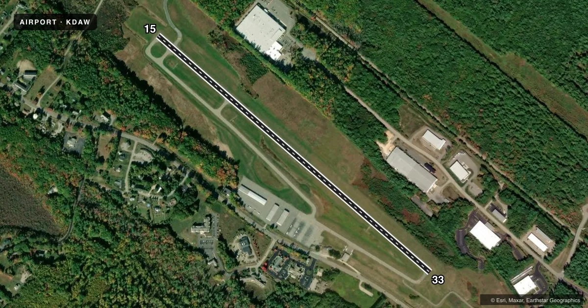
Airport sketch
Runways drawn to scale from FAA survey coordinates, rendered over satellite imagery. Not for navigation.
Approaches & charts
Services on the field
Fuel grades, oxygen, maintenance, ramp storage and lighting — as declared to the FAA by the airport operator.
Fuel & services
- Fuel
- 100LL
- Oxygen (bottled)
- Not available
- Oxygen (bulk)
- Not available
- Airframe repair
- Major
- Power plant repair
- Major
Ramp & ground
- Transient storage
- Tie-down
- Landing fee
- No fee published
- Customs
- Not available
- Lighting schedule
- SEE RMK
- Beacon schedule
- SS-SR
- Beacon
- White / Green (civil land)(WG)
- Wind indicator
- Lighted
- Segmented circle
- Yes
Fuel & FBOs
Cheapest 100LL and Jet A on the field and nearby. Always confirm with the FBO before taxi.
Airport notes
Surface conditions, obstructions, local procedures, lighting outages and other notes published with each FAA cycle.
General notes
- DEER ON & INVOF ARPT AFT SS.
- RWY 33 DSGND CALM WIND RWY.
- ULTRALIGHT; ANTIQUE & NORDO TFC IN GOOD WX.
- FOR CD CTC BOSTON APCH AT 603-594-5552.
Lighting notes
- BCN LCTD 3000 FT NW OF ARPT.
- ACTVT ODALS RWY 33; REIL RWY 15; PAPI RWY 33; MIRL RWY 15/33; WIND CONE LGT - CTAF.
Fuel notes
- 100LLSELF SVC 100LL AVBL 24 HRS WITH CREDIT CARD.
Other notes
- ESTAB PRIOR TO 1959.
- 1EXC HOLS.
- MANAGERMGR PHONE 603-948-1142.
VFR map & nearby airports
VFR sectional. Tap any ICAO chip to open that airport.
Key facts · KDAW
Answer card- ICAO
- KDAW
- Name
- SKYHAVEN
- Location
- ROCHESTER, NEW HAMPSHIRE
- Elevation
- 322.1 ft MSL
- Traffic pattern altitude
- 1,122.1 ft MSL (800 AGL)
- Control tower
- Non-towered (use CTAF)
- Total runways
- 1
- Longest runway
- 15/33 · 4,201 ft
- Published ILS approaches
- 0
- Published frequencies
- 4
- Magnetic variation
- 16°
- Current flight rules
- VFR
- Current wind
- 000° at 0 kt
- Favored runway now
- –
Skyhaven Airport sits in Rochester, New Hampshire. Field elevation is 322.1 ft MSL. The airport has one runway. Runway 15/33 is 4,201 ft of asphalt, so plan performance with that length in mind. There is no control tower. Boston Approach handles clearance delivery. The published frequencies are 125.05 and 269.4 for approach or departure. CTAF and UNICOM are both on 122.7.
There are no published ILS approaches here. Pattern altitude is 800 ft AGL, which is 1,122.1 ft MSL. Runway 33 is the calm wind runway. Lighting is available on the runway. The approach lighting system is active for runway 33. Runway end identifier lights are on runway 15. A PAPI is on runway 33. The beacon sits about 3,000 feet northwest of the airport.
Pease Development Authority is on the field. It carries 100LL. Self-serve 100 low lead fuel is available 24 hours with credit card. Deer are reported on and near the airport after sunset. Ultralight, antique and no-radio traffic can show up in good weather. That makes a good lookout important, especially in the pattern. If you need current operating details or any local restrictions, check the current FAA Chart Supplement or call the airport operator directly.