METAR & TAF KSFM
Current METAR
Observed 11:56Z
KSFM 271156Z AUTO 00000KT 10SM CLR 16/13 A2987 RMK AO2 SLP115 T01610128 10161 20061 53006
- Wind
- 000° @ 0 kt
- Visibility
- 10 SM
- Temp / Dew
- 16°C / 13°C
- Altimeter
- 29.87 inHg
- Clouds
- CLR
- Density alt
- 485 ft
- Ceiling
- Unlimited
- Rules
- VFR
Airport info & contacts
Manager on record, flight service, ARTCC, attendance schedule and pattern altitude — published by the FAA and refreshed every 28 days.
Location
- From city
- 4 NM SE
- VFR sectional
- NEW YORK
- ARTCC
- ZBW · BOSTON
- NOTAM facility
- SFM (NOTAM-D)
Airport manager
- Name
- M. ALLISON NAVIA
- Phone
- 207-324-3172
- Address
- 9 PRESIDENTIAL LN, SANFORD ME 04073
Flight service · Hours
- FSS BGR
- BANGOR1-800-WX-BRIEF
- Attendance
- OCT-MAY · 0700-1700
- JUN-SEPT · 0700-1900
Frequencies
Tap any row to copy the frequency to your clipboard.
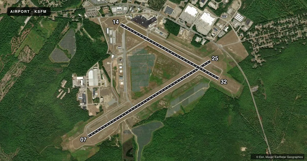
Runways & pattern
Full pagePattern entry · RWY 07
LEFT TRAFFIC| Runway | Heading (°M) | Length | Surface | Traffic |
|---|---|---|---|---|
| 07/25 | 41° / 221° | 6,389 ft | ASPH | Standard L |
| 14/32 | 102° / 282° | 4,999 ft | ASPH | Standard L |
Runway end performance
| End | TORA | TODA | ASDA | LDA | VGSI | Approach lights | Obstruction |
|---|---|---|---|---|---|---|---|
| 07 | — | — | — | — | PAPI 4-box left(3°) | — | 30', tree, 1074' from thr, 278' R of cntrln, slope 29 |
| 25 | — | — | — | — | PAPI 4-box left(3°) | ODALS | 18', pline, 695' from thr, 460' R of cntrln, slope 27 |
| 14 | — | — | — | — | PAPI 4-box left(4°) | — | 68', tree, 516' from thr, 120' R of cntrln, slope 4 |
| 32 | — | — | — | — | PAPI 4-box left(3°) | — | — |
Declared distances in feet. TORA = takeoff run available, TODA = takeoff distance, ASDA = accelerate-stop, LDA = landing distance.
Airport sketch
Runways drawn to scale from FAA survey coordinates, rendered over satellite imagery. Not for navigation.
Approaches & charts
ILS · 1
Services on the field
Fuel grades, oxygen, maintenance, ramp storage and lighting — as declared to the FAA by the airport operator.
Fuel & services
- Fuel
- 100LLAMOGAS
- Oxygen (bottled)
- HIGH/LOW
- Oxygen (bulk)
- Not available
- Airframe repair
- Major
- Power plant repair
- Major
- Other services
- AMB,INSTR,RNTL,SURV
Ramp & ground
- Transient storage
- Tie-down
- Hangar
- Landing fee
- No fee published
- Customs
- Not available
- Lighting schedule
- SEE RMK
- Beacon schedule
- SS-SR
- Beacon
- White / Green (civil land)(WG)
- Wind indicator
- Lighted
- Segmented circle
- Yes
Fuel & FBOs
Cheapest 100LL and Jet A on the field and nearby. Always confirm with the FBO before taxi.
Airport notes
Surface conditions, obstructions, local procedures, lighting outages and other notes published with each FAA cycle.
General notes
- WILDLIFE ON & INVOF ARPT.
- CALM WIND PREFERRED RWY 32.
- 24 HR FUEL AVBL WITH MAJOR CREDIT CARD FOR 100LL, A & MOGAS.
- CONDS NOT MNT DLY 1600-0700 EST.
- FBO AFT HRS CALL-OUT FEE - 207-324-8919.
- FOR CD WHEN APCH CLSD CTC BOSTON ARTCC AT 603-879-6859.
- HIGH VOL FIXED AND ROTARY WING FLT TRNG IN VCNTY.
Lighting notes
- ACTVT ODALS RWY 25; REIL RWY 07; PAPI RWY 07 & 25; HIRL 07/25; MIRL 14/32; TWY LGTS - CTAF. TWY LGTS INOP DALGT HRS.
Approach & departure obstructions
- 07APCH RATIO 49:1 AT DTHR.
- 14APCH RATIO 20:1 AT DTHR.
Other notes
- EXISTED PRIOR TO 1959.
VFR map & nearby airports
VFR sectional. Tap any ICAO chip to open that airport.
Key facts · KSFM
Answer card- ICAO
- KSFM
- Name
- SANFORD SEACOAST RGNL
- Location
- SANFORD, MAINE
- Elevation
- 244.1 ft MSL
- Traffic pattern altitude
- 1,244.1 ft MSL (1,000 AGL)
- Control tower
- Non-towered (use CTAF)
- Total runways
- 2
- Longest runway
- 07/25 · 6,389 ft
- Published ILS approaches
- 1
- Published frequencies
- 5
- Magnetic variation
- 17°
- Current flight rules
- VFR
- Current wind
- 000° at 0 kt
- Favored runway now
- –
Sanford Seacoast Rgnl sits in Sanford, Maine at 244.1 ft MSL. It has two asphalt runways. The longest is 07/25 at 6,389 ft. The field is non-towered. Pattern altitude is not published, so use the standard 1,000 ft AGL for light piston traffic unless the current FAA Chart Supplement says otherwise. One ILS is published for runway 07.
Southern Maine Aviation is on the field. It carries 100LL, Jet A and mogas. Twenty-four hour fuel is available with a major credit card. The airport remarks also note wildlife on and near the field. High volume fixed-wing and rotary-wing training happens in the area. Expect active traffic and stay sharp in the pattern.
Runway 25 has activated approach lighting. Runway 07 has runway end identifier lights. PAPI is published for runways 07 and 25. High intensity lights are on 07 and 25. Medium intensity lights are on 14 and 32. Taxiway lights are tied to CTAF. They are inoperative in daylight hours. The remarks also note a displaced-threshold approach ratio issue on both runway 07 and runway 14. Check the current FAA Chart Supplement before you go. If you need clearance delivery when approach is closed, use Boston ARTCC as published in the remarks.