METAR & TAF 7B3
7B3 does not publish a METAR.
Showing the nearest reporting station: KPSM (PORTSMOUTH INTL AT PEASE) · 7.0 NM away. Conditions at 7B3 may differ.
METAR · KPSM
Observed 15:55Z
KPSM 271555Z 12007KT 10SM CLR 26/11 A2982 RMK AO2A SLP100 T02560110
- Wind
- 120° @ 7 kt
- Visibility
- 10 SM
- Temp / Dew
- 26°C / 11°C
- Altimeter
- 29.82 inHg
- Clouds
- CLR
- Density alt
- 1,559 ft
- Ceiling
- Unlimited
- Rules
- VFR
Airport info & contacts
Manager on record, flight service, ARTCC, attendance schedule and pattern altitude — published by the FAA and refreshed every 28 days.
Location
- From city
- 2 NM N
- VFR sectional
- NEW YORK
- ARTCC
- ZBW · BOSTON
- NOTAM facility
- BGR (NOTAM-D)
Airport manager
- Name
- GARRETT MILLER
- Phone
- 603-964-6749
- Address
- 9A LAFAYETTE RD, NORTH HAMPTON NH 03862
Flight service · Hours
- FSS BGR
- BANGOR1-800-WX-BRIEF
- Attendance
- 0800-1600
Frequencies
Tap any row to copy the frequency to your clipboard.
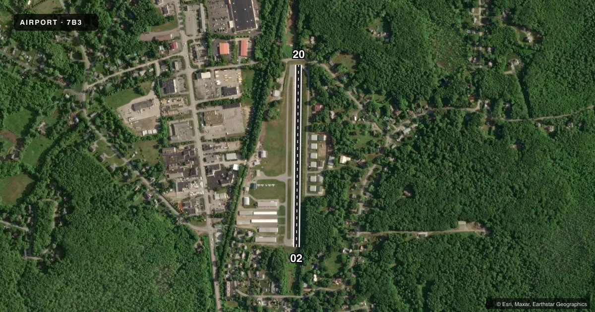
Runways & pattern
Full pagePattern entry · RWY 20
LEFT TRAFFICRunway end performance
| End | TORA | TODA | ASDA | LDA | VGSI | Approach lights | Obstruction |
|---|---|---|---|---|---|---|---|
| 02 | — | — | — | — | — | — | 65', trees, 217' from thr, 83' R of cntrln, slope 0 |
Declared distances in feet. TORA = takeoff run available, TODA = takeoff distance, ASDA = accelerate-stop, LDA = landing distance.
Airport sketch
Runways drawn to scale from FAA survey coordinates, rendered over satellite imagery. Not for navigation.
Approaches & charts
Services on the field
Fuel grades, oxygen, maintenance, ramp storage and lighting — as declared to the FAA by the airport operator.
Fuel & services
- Fuel
- 100LLMOGAS
- Oxygen (bottled)
- Not available
- Oxygen (bulk)
- Not available
- Airframe repair
- Major
- Power plant repair
- Minor
- Other services
- INSTR,RNTL,SALES
Ramp & ground
- Transient storage
- Tie-down
- Hangar
- Landing fee
- No fee published
- Lighting schedule
- SEE RMK
- Wind indicator
- Lighted
- Segmented circle
- No
Fuel & FBOs
Cheapest 100LL and Jet A on the field and nearby. Always confirm with the FBO before taxi.
Airport notes
Surface conditions, obstructions, local procedures, lighting outages and other notes published with each FAA cycle.
General notes
- WILDLIFE ON & INVOF ARPT.
- ROAD AT RWY 20 THR WITH MOD VEHICLE TFC.
- NMRS NORDO ACFT OPRG AT ARPT.
- EXTSV STUDENT PILOT & TRNG OPS AT ARPT.
- PARL RWY OPS NOT PMTD. PILOT WILL DESIGNATE & MAKE RADIO CALL TO ADZ TURF OR GRASS LNDG/TKOF.
- CTN: SHORT & SOFT FLD OPS. FOR SHORT FLD TRNG OR INFO PLS CTC AMGR 603-817-6617.
- FOR CD CTC BOSTON APCH AT 603-594-5552.
Lighting notes
- CTC AMGR AT 603-817-6617 FOR ACTVTN INSTRNS.
Fuel notes
- 100LLSELF SVC 100LL & MOGAS AVBL 24 HRS VIA CREDIT CARD.
Runway surface & condition
- 02/20NSTD LIRL.
- 02/20RWY 02/20 2105 FT X 46 FT ASPH ON W PORTION, 2105 FT X 75 FT ON E PORTION.
Approach & departure obstructions
- 02LOW GROWTH 110 FT L AND 50 FT R OF CNTRLN 100 FT FM RWY END.
- 2055 FT TREES 0+ FT FM RWY END R OF CNTRLN, 44 FT TREES 100 FT FM RWY END L OF CNTRLN.
- 20NSTD DTHR; SNGL RED/GREEN LGT EACH SIDE. THR SITING SFC 10:1 SLP.
- 02OBSTN EXCEEDS A 45 DEG SLP.
Other notes
- ESTAB PRIOR 1959.
- 1EXC THANKSGIVING & CHRISTMAS.
VFR map & nearby airports
VFR sectional. Tap any ICAO chip to open that airport.
Key facts · 7B3
Answer card- ICAO
- 7B3
- Name
- HAMPTON AIRFIELD
- Location
- HAMPTON, NEW HAMPSHIRE
- Elevation
- 93 ft MSL
- Traffic pattern altitude
- 1,093 ft MSL (1,000 AGL)
- Control tower
- Non-towered (use CTAF)
- Total runways
- 1
- Longest runway
- 02/20 · 2,105 ft
- Published ILS approaches
- 0
- Published frequencies
- 2
- Magnetic variation
- 16°
- Current flight rules
- VFR
- Current wind
- 120° at 7 kt
- Favored runway now
- RWY 20
Hampton Airfield sits in Hampton, New Hampshire. Field elevation is 93 ft MSL. It has one runway, 02/20, at 2,105 ft. There is no control tower. CTAF and UNICOM are both 122.8. No ILS approaches are published. The pattern altitude is not published. Use the standard 1,000 ft AGL pattern for light piston aircraft unless the current Chart Supplement says otherwise.
Hampton Airfield is an on-field fuel stop with Hampton Airfield on site. It carries 100LL and mogas. Self-serve fuel is available 24 hours by credit card. The field has been established since before 1959. Expect a short-field mindset here. The published remarks call out trees near runway 20, low growth near runway 02, a road at the runway 20 threshold with vehicle traffic and wildlife on and near the airport. Runway 20 also has a nonstandard displaced threshold with low-intensity lighting. Parallel runway operations are not permitted. The pilot should call out whether the surface use is turf or grass when making radio calls. For clearance delivery, Boston Approach is listed in the remarks. If you are planning short or soft field work, contact the airport manager first.