METAR & TAF 7B2
7B2 does not publish a METAR.
Showing the nearest reporting station: KCEF (WESTOVER ARB/METRO) · 8.7 NM away. Conditions at 7B2 may differ.
METAR · KCEF
Observed 10:55Z
KCEF 271055Z AUTO 00000KT 10SM CLR 15/13 A2982 RMK AO2 SLP100 T01500132 CHINO RWY23 $
- Wind
- 000° @ 0 kt
- Visibility
- 10 SM
- Temp / Dew
- 15°C / 13°C
- Altimeter
- 29.82 inHg
- Clouds
- CLR
- Density alt
- 275 ft
- Ceiling
- Unlimited
- Rules
- VFR
Airport info & contacts
Manager on record, flight service, ARTCC, attendance schedule and pattern altitude — published by the FAA and refreshed every 28 days.
Location
- From city
- 1 NM NE
- VFR sectional
- NEW YORK
- ARTCC
- ZBW · BOSTON
- NOTAM facility
- BTV (NOTAM-D)
Airport manager
- Name
- RICHARD MACISAAC
- Phone
- 860-833-7602
- Address
- 160 OLD FERRY RD, NORTHAMPTON MA 01060
Flight service · Hours
- FSS BTV
- BURLINGTON1-800-WX-BRIEF
- Attendance
- 0800-1800
Frequencies
Tap any row to copy the frequency to your clipboard.
Runways & pattern
Full pagePattern entry · RWY 14
LEFT TRAFFICRunway end performance
| End | TORA | TODA | ASDA | LDA | VGSI | Approach lights | Obstruction |
|---|---|---|---|---|---|---|---|
| 14 | — | — | — | — | PAPI 4-box left(4.5°) | — | 60', trees, 600' from thr, 210' R of cntrln, slope 6 |
| 32 | — | — | — | — | — | — | 32', trees, 1000' from thr, 51' R of cntrln, slope 25 |
Declared distances in feet. TORA = takeoff run available, TODA = takeoff distance, ASDA = accelerate-stop, LDA = landing distance.
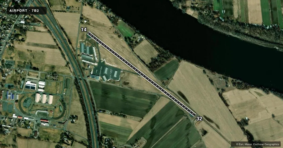
Airport sketch
Runways drawn to scale from FAA survey coordinates, rendered over satellite imagery. Not for navigation.
Approaches & charts
Services on the field
Fuel grades, oxygen, maintenance, ramp storage and lighting — as declared to the FAA by the airport operator.
Fuel & services
- Fuel
- 100LL
- Oxygen (bottled)
- Not available
- Oxygen (bulk)
- Not available
- Airframe repair
- Major
- Power plant repair
- Major
- Other services
- INSTR,RNTL
Ramp & ground
- Transient storage
- Tie-down
- Hangar
- Landing fee
- No fee published
- Customs
- Not available
- Lighting schedule
- SEE RMK
- Beacon schedule
- SS-SR
- Beacon
- White / Green (civil land)(WG)
- Wind indicator
- Lighted
- Segmented circle
- No
Fuel & FBOs
Cheapest 100LL and Jet A on the field and nearby. Always confirm with the FBO before taxi.
Airport notes
Surface conditions, obstructions, local procedures, lighting outages and other notes published with each FAA cycle.
General notes
- ARPT CLSD TO ALL ACFT & HEL CRTFYD FOR 12500 LBS & OVR.
- LDG FEE FOR COML ACFT.
- FEE & PPR FOR COML BLN OPS.
- FOR CD CTC BRADLEY APCH AT 860-386-3597.
- GLDR ACT ON & INVOF ARPT MAY-OCT.
- COLD TEMPERATURE AIRPORT. ALTITUDE CORRECTION REQUIRED AT OR BELOW -24C.
Lighting notes
- ACTVT MIRL RWY 14/32 - CTAF.
Fuel notes
- 100LLFUEL IS 24 HR SELF-SERVE.
Approach & departure obstructions
- 1415 FT ROAD IN PRIM SFC.
- 32ROAD IN PRIM SFC 50 FT FM THR.
- 32APCH 38:1 TO DTHR.
Other notes
- THIS AIRPORT HAS BEEN SURVEYED BY THE NATIONAL GEODETIC SURVEY.
- PAY PHONE AVAILABLE.
- MANAGERRICHM@FLY7B2.COM
VFR map & nearby airports
VFR sectional. Tap any ICAO chip to open that airport.
Key facts · 7B2
Answer card- ICAO
- 7B2
- Name
- NORTHAMPTON
- Location
- NORTHAMPTON, MASSACHUSETTS
- Elevation
- 121.4 ft MSL
- Traffic pattern altitude
- 1,121.4 ft MSL (1,000 AGL)
- Control tower
- Non-towered (use CTAF)
- Total runways
- 1
- Longest runway
- 14/32 · 3,335 ft
- Published ILS approaches
- 0
- Published frequencies
- 5
- Magnetic variation
- 15°
- Current flight rules
- VFR
- Current wind
- 000° at 0 kt
- Favored runway now
- –
Northampton (7B2) sits in Northampton, Massachusetts. Field elevation is 121.4 ft MSL. The airport has one runway. Runway 14/32 is 3,335 ft long and paved with asphalt. There is no control tower. Use CTAF 122.7 for local traffic. No ILS approaches are published here.
Pattern altitude is not published. Use the standard 1,000 ft AGL pattern unless the current Chart Supplement says otherwise. The airport is on the smaller side, so plan for a short field profile if you are bringing in a heavier airplane. The field is closed to aircraft and helicopters certified for 12,500 lb and over. Glider activity is listed from May through October, so keep your scan sharp in the pattern and on climbout.
Northampton Aeronautics is on the field. It carries 100LL. 24-hour self-serve 100LL is published in the remarks. The runway lights on 14/32 are medium intensity and are activated by CTAF. There is a road in the primary surface near the runway ends, including one at the 14 end and one near the threshold of 32. The airport is also listed as a cold temperature airport, so altitude correction is required at or below minus 24 degrees Celsius. Check current procedures before you go.