METAR & TAF KPSF
Current METAR
Observed 12:54Z
KPSF 271254Z AUTO 00000KT 10SM CLR 20/16 A2986 RMK AO2 SLP090 T02000156
- Wind
- 000° @ 0 kt
- Visibility
- 10 SM
- Temp / Dew
- 20°C / 16°C
- Altimeter
- 29.86 inHg
- Clouds
- CLR
- Density alt
- 2,148 ft
- Ceiling
- Unlimited
- Rules
- VFR
Airport info & contacts
Manager on record, flight service, ARTCC, attendance schedule and pattern altitude — published by the FAA and refreshed every 28 days.
Location
- From city
- 2 NM W
- VFR sectional
- NEW YORK
- ARTCC
- ZBW · BOSTON
- NOTAM facility
- PSF (NOTAM-D)
Airport manager
- Name
- ANITA AKOR
- Phone
- 413-448-9790
- Address
- PITTSFIELD MUNICIPAL AIRPORT, 832 TAMARACK RD, PITTSFIELD MA 01201
Flight service · Hours
- FSS BTV
- BURLINGTON1-800-WX-BRIEF
- Attendance
- 0700-1500
Frequencies
Tap any row to copy the frequency to your clipboard.
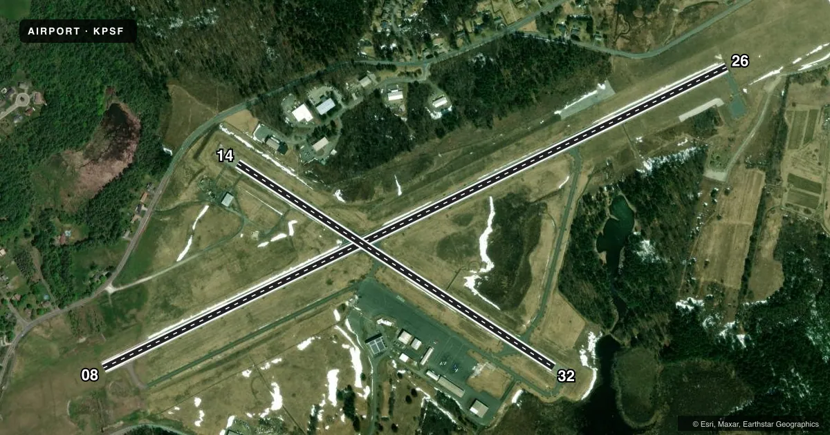
Runways & pattern
Full pagePattern entry · RWY 08
LEFT TRAFFIC| Runway | Heading (°M) | Length | Surface | Traffic |
|---|---|---|---|---|
| 08/26 | 49° / 229° | 5,792 ft | ASPH | 26 R |
| 14/32 | 108° / 288° | 3,147 ft | ASPH | 32 R |
Runway end performance
| End | TORA | TODA | ASDA | LDA | VGSI | Approach lights | Obstruction |
|---|---|---|---|---|---|---|---|
| 08 | — | — | — | — | — | — | 35', trees, 750' from thr, 350' R of cntrln, slope 15 |
| 26 | — | — | — | — | PAPI 4-box left(3°) | — | — |
| 14 | — | — | — | — | — | — | 50', trees, 1000' from thr, 125' R of cntrln, slope 16 |
| 32 | — | — | — | — | — | — | 20', trees, 600' from thr, 120' R of cntrln, slope 20 |
Declared distances in feet. TORA = takeoff run available, TODA = takeoff distance, ASDA = accelerate-stop, LDA = landing distance.
Airport sketch
Runways drawn to scale from FAA survey coordinates, rendered over satellite imagery. Not for navigation.
Approaches & charts
ILS · 1
Services on the field
Fuel grades, oxygen, maintenance, ramp storage and lighting — as declared to the FAA by the airport operator.
Fuel & services
- Fuel
- 100LLAA+
- Oxygen (bottled)
- Low pressure
- Oxygen (bulk)
- Not available
- Airframe repair
- Major
- Power plant repair
- Major
- Other services
- AMB,AVNCS,CHTR,INSTR,RNTL,SALES
Ramp & ground
- Transient storage
- Tie-down
- Hangar
- Landing fee
- Yes
- Customs
- Not available
- Lighting schedule
- SEE RMK
- Beacon schedule
- SS-SR
- Beacon
- White / Green (civil land)(WG)
- Wind indicator
- Yes
- Segmented circle
- Yes
Fuel & FBOs
Cheapest 100LL and Jet A on the field and nearby. Always confirm with the FBO before taxi.
Airport notes
Surface conditions, obstructions, local procedures, lighting outages and other notes published with each FAA cycle.
General notes
- OBSTN LGTD POLES 0.9 NM SE AT 1960 FT; 1.1 NM SE AT 1470 FT; 1.7 NM SW AT 2171 FT (OTS INDEFLY); 1.3 NM NE AT 1330 FT; 2.3 NM NW AT 1890 FT (OTS INDEFLY).
- BIRDS & WILDLIFE ON & INVOF ARPT.
- ALL ACFT USE TWY A, C & D FOR RWY 08-26. TWY A USE LTD TO ACFT WITH WINGSPAN LESS THAN 79 FT. AFT BACK TAX RWY 26 USE TWY D TO TURN ARND.
- CK NOTAMS FOR ARPT COND. AIRFIELD SFC COND NOT MNT & SNOW REMOVAL NOT GUARANTEED BTN 1500-0700.
- NOISE ABATEMENT PROCS IN EFCT 2300-0700.
- FOR CD CTC ALBANY APCH AT 518-862-2299.
- FBO ATNDD MON-FRI 0800-1800, SAT-SUN 0800-1700. FOR FUEL AFT HRS CALL 413-443-6700.
- RWY 14-32 CK NOTAMS FOR CHGS TO LEN & WID.
- COLD TEMPERATURE AIRPORT. ALTITUDE CORRECTION REQUIRED AT OR BELOW -21C.
Lighting notes
- ACTVT REIL RWY 26; PAPI RWY 26; MIRL RWY 08/26 & 14/32 - CTAF.
Runway surface & condition
- 08/26PCR VALUE: 326/F/D/X/T
- 14/32PCR VALUE: 42/F/D/X/T
Other notes
- BUILT PRIOR TO 1959.
- LDG & PRKG FEES.
VFR map & nearby airports
VFR sectional. Tap any ICAO chip to open that airport.
Key facts · KPSF
Answer card- ICAO
- KPSF
- Name
- PITTSFIELD MUNI
- Location
- PITTSFIELD, MASSACHUSETTS
- Elevation
- 1,188.5 ft MSL
- Traffic pattern altitude
- 2,188.5 ft MSL (1,000 AGL)
- Control tower
- Non-towered (use CTAF)
- Total runways
- 2
- Longest runway
- 08/26 · 5,792 ft
- Published ILS approaches
- 1
- Published frequencies
- 5
- Magnetic variation
- 15°
- Current flight rules
- VFR
- Current wind
- 000° at 0 kt
- Favored runway now
- –
Pittsfield Muni is in Pittsfield, Massachusetts. Field elevation is 1,188.5 ft MSL. The airport has two asphalt runways. The longest is runway 08/26 at 5,792 ft. Runway 14/32 is 3,147 ft. There is no control tower. Use CTAF 122.7 for local traffic. Pattern altitude is not published. For light piston planning, use the standard 1,000 ft AGL pattern unless the current Chart Supplement or local procedures say otherwise.
Runway 26 has an ILS. Runway 26 also has REIL and PAPI lighting. Both runways have medium intensity runway lighting. Lyon Aviation is on the field. It carries 100LL, Jet A and Jet A Prist. Call (413) 443-6700 for after-hours fuel or current ramp details. The FBO is attended Monday through Friday from 0800 to 1800. Weekend hours are 0800 to 1700.
This is an airport with published noise abatement from 2300 to 0700. Check NOTAMs before departure. The field has obstructions near several quadrants, so stay sharp on arrival and departure. Birds and wildlife are also reported on and near the airport. Taxiway use on runway 08/26 is specific, so review the current Chart Supplement before you go. Snow removal is not guaranteed between 1500 and 0700, so winter arrivals deserve extra planning.