METAR & TAF 4B0
4B0 does not publish a METAR.
Showing the nearest reporting station: KALB (ALBANY INTL) · 11.4 NM away. Conditions at 4B0 may differ.
METAR · KALB
Observed 10:51Z
KALB 271051Z 00000KT 10SM FEW090 BKN250 19/16 A2984 RMK AO2 SLP102 T01890161 $
- Wind
- 000° @ 0 kt
- Visibility
- 10 SM
- Temp / Dew
- 19°C / 16°C
- Altimeter
- 29.84 inHg
- Clouds
- BKN
- Density alt
- 822 ft
- Ceiling
- 25,000 ft AGL
- Rules
- VFR
Airport info & contacts
Manager on record, flight service, ARTCC, attendance schedule and pattern altitude — published by the FAA and refreshed every 28 days.
Location
- From city
- 2 NM N
- VFR sectional
- NEW YORK
- ARTCC
- ZBW · BOSTON
- NOTAM facility
- BTV (NOTAM-D)
Airport manager
- Name
- TED ZABINSKI
- Phone
- (518) 281-5430
- Address
- 6 OLD SCHOOL ROAD, SELKIRK NY 12158
Flight service · Hours
- FSS BTV
- BURLINGTON1-800-WX-BRIEF
- Attendance
- NOV-MAR · 0800-1600
- APR-OCT · 0600-2100
Frequencies
Tap any row to copy the frequency to your clipboard.
Runways & pattern
Full pagePattern entry · RWY 01
LEFT TRAFFICRunway end performance
| End | TORA | TODA | ASDA | LDA | VGSI | Approach lights | Obstruction |
|---|---|---|---|---|---|---|---|
| 01 | — | — | — | — | — | — | 27', tree, 226' from thr, 69' R of cntrln, slope 1 |
| 19 | — | — | — | — | — | — | 30', tree, 428' from thr, 143' R of cntrln, slope 7 |
Declared distances in feet. TORA = takeoff run available, TODA = takeoff distance, ASDA = accelerate-stop, LDA = landing distance.
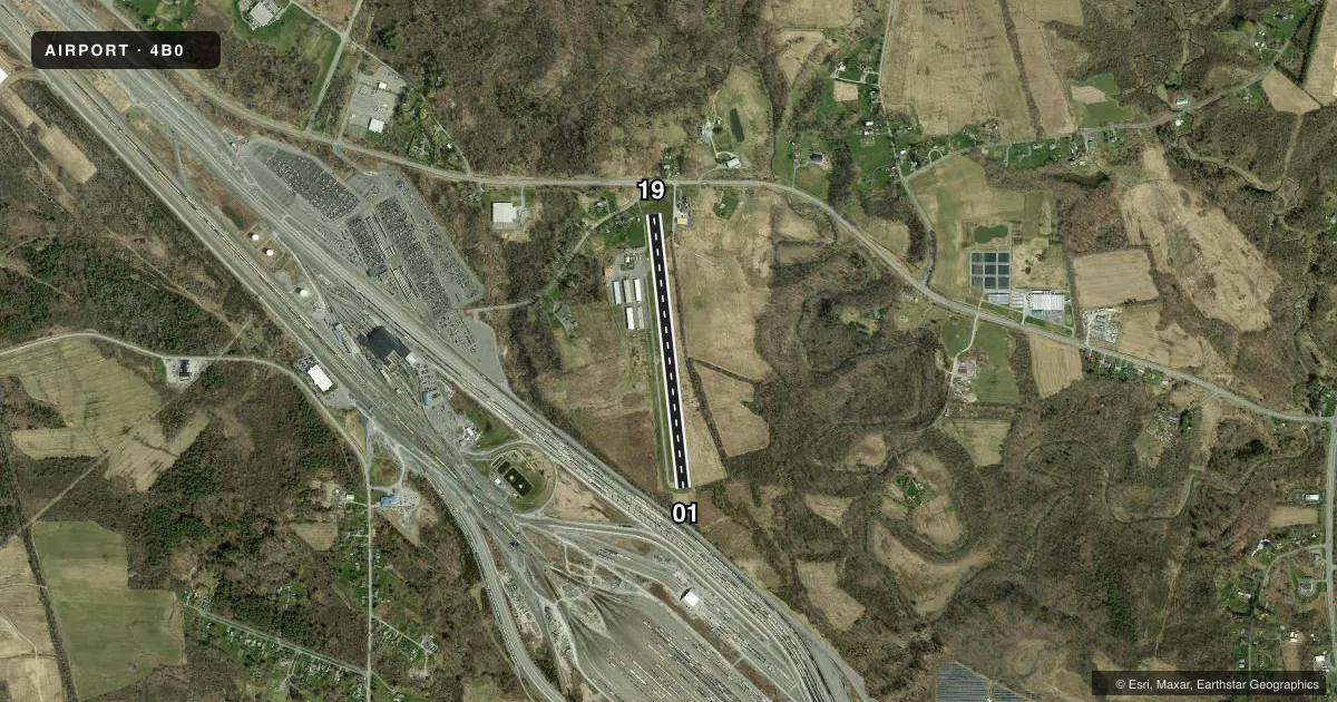
Airport sketch
Runways drawn to scale from FAA survey coordinates, rendered over satellite imagery. Not for navigation.
Approaches & charts
Services on the field
Fuel grades, oxygen, maintenance, ramp storage and lighting — as declared to the FAA by the airport operator.
Fuel & services
- Fuel
- 100LLA
- Oxygen (bottled)
- Not available
- Oxygen (bulk)
- Not available
- Airframe repair
- Major
- Power plant repair
- Major
- Other services
- AMB,INSTR
Ramp & ground
- Transient storage
- Hangar
- Landing fee
- No fee published
- Lighting schedule
- SEE RMK
- Wind indicator
- Lighted
- Segmented circle
- No
Fuel & FBOs
Cheapest 100LL and Jet A on the field and nearby. Always confirm with the FBO before taxi.
Airport notes
Surface conditions, obstructions, local procedures, lighting outages and other notes published with each FAA cycle.
General notes
- ARPT CLSD TO ACFT OVER 12500 LBS.
- BIRDS ON AND INVOF ARPT.
- HEL NOISE ABATEMENT PROC IN EFCT. VFR DEP MNTN RWY HDG TIL REACHING 500 FT AGL. AVOID ARR AND DEP TO/FM THE WEST.
- 17 FT RAILROAD ACRS CNTRLN 200 FT S OF RWY 01
- FOR CD CTC ALBANY APCH AT 518-862-2299.
Lighting notes
- ACTVT LIRL RWY 01/19; WDI LGT - CTAF.
Approach & departure obstructions
- 01+18 FT TREE, 178 FT FM RWY, 116 FT L. 6 FT FENCE 125 FT R & 115 FT L.
- 19+42 FT POLE, 194 FT FM RWY, 176 FT L.
- 01RWY 01 CLNC SLP 18:1 TO DTHR DUE TO +18 FT TREE, 328 FT FM DTHR, 116 FT L.
- 19CLNCE SLOPE 12:1 TO DTHR DUE TO +44 FT TREE, 535 FT FM DTHR, 177 FT L.
VFR map & nearby airports
VFR sectional. Tap any ICAO chip to open that airport.
Key facts · 4B0
Answer card- ICAO
- 4B0
- Name
- SOUTH ALBANY
- Location
- SOUTH BETHLEHEM, NEW YORK
- Elevation
- 195.5 ft MSL
- Traffic pattern altitude
- 1,195.5 ft MSL (1,000 AGL)
- Control tower
- Non-towered (use CTAF)
- Total runways
- 1
- Longest runway
- 01/19 · 2,853 ft
- Published ILS approaches
- 0
- Published frequencies
- 3
- Magnetic variation
- 14°
- Current flight rules
- VFR
- Current wind
- 000° at 0 kt
- Favored runway now
- –
South Albany Airport sits in South Bethlehem, New York. Field elevation is 195.5 ft MSL. The airport has one runway. Runway 01/19 is 2,853 ft long and asphalt. There is no control tower. No ILS approaches are published here.
Pattern altitude is not published. Use 1,000 ft AGL for light piston traffic unless the current Chart Supplement says otherwise. The field uses low intensity runway lights on 01/19. The wind direction indicator light is on CTAF. South Albany Airport Corp is on the field. It carries AVGAS 100LL and Jet A. Call (518) 767-9189 for current service details.
This is a field where the published remarks matter. Runway 01 has obstacle clearance issues near the departure end. Runway 19 also has obstacles on the departure side. There is a railroad crossing south of runway 01. Helicopter noise abatement is in effect. VFR departures are expected to hold runway heading until 500 ft AGL. Arrivals and departures to and from the west should be avoided. The airport is closed to aircraft over 12,500 lb. Birds are reported on and near the airport. For clearance delivery, contact Albany Approach at 518-862-2299 before departure if you need it. Check the current Chart Supplement for any updates before you go.