METAR & TAF 4B1
4B1 does not publish a METAR.
Showing the nearest reporting station: KSCH (SCHENECTADY COUNTY) · 10.6 NM away. Conditions at 4B1 may differ.
METAR · KSCH
Observed 12:55Z
KSCH 261255Z 00000KT 10SM CLR 20/15 A2996
- Wind
- 000° @ 0 kt
- Visibility
- 10 SM
- Temp / Dew
- 20°C / 15°C
- Altimeter
- 29.96 inHg
- Clouds
- CLR
- Density alt
- 1,436 ft
- Ceiling
- Unlimited
- Rules
- VFR
Airport info & contacts
Manager on record, flight service, ARTCC, attendance schedule and pattern altitude — published by the FAA and refreshed every 28 days.
Location
- From city
- 0 NM S
- VFR sectional
- NEW YORK
- ARTCC
- ZBW · BOSTON
- NOTAM facility
- BTV (NOTAM-D)
Airport manager
- Name
- MARY ELIZABETH SLEVIN
- Phone
- 518-390-1133
- Address
- 5051 WESTERN TURNPIKE, DUANESBURG NY 12056
Flight service · Hours
- FSS BTV
- BURLINGTON1-800-WX-BRIEF
- Attendance
- UNATTENDED
Frequencies
Tap any row to copy the frequency to your clipboard.
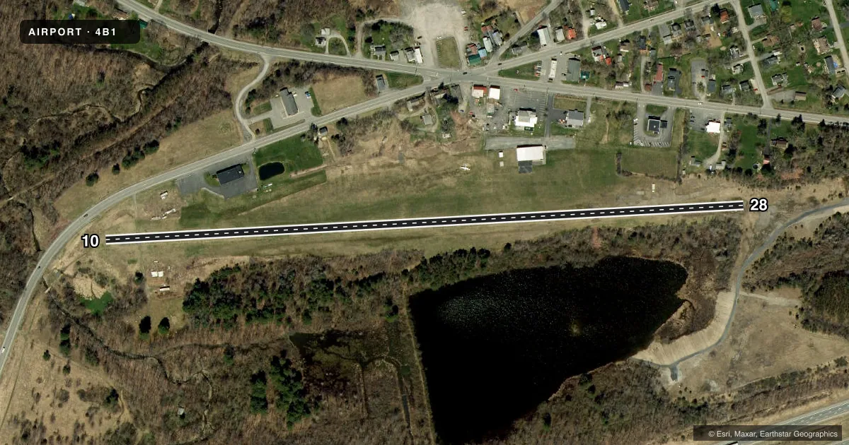
Runways & pattern
Full pagePattern entry · RWY 10
LEFT TRAFFICRunway end performance
| End | TORA | TODA | ASDA | LDA | VGSI | Approach lights | Obstruction |
|---|---|---|---|---|---|---|---|
| 10 | — | — | — | — | — | — | 51', road, 255' from thr, 119' R of cntrln, slope 5 |
| 28 | — | — | — | — | — | — | 60', trees, 249' from thr, 106' R of cntrln, slope 4 |
Declared distances in feet. TORA = takeoff run available, TODA = takeoff distance, ASDA = accelerate-stop, LDA = landing distance.
Airport sketch
Runways drawn to scale from FAA survey coordinates, rendered over satellite imagery. Not for navigation.
Approaches & charts
Services on the field
Fuel grades, oxygen, maintenance, ramp storage and lighting — as declared to the FAA by the airport operator.
Fuel & services
- Fuel
- 100LL
- Oxygen (bottled)
- Not available
- Oxygen (bulk)
- Not available
- Airframe repair
- Not available
- Power plant repair
- Not available
Ramp & ground
- Transient storage
- Tie-down
- Landing fee
- No fee published
- Customs
- Not available
- Wind indicator
- Yes
- Segmented circle
- No
Fuel & FBOs
Cheapest 100LL and Jet A on the field and nearby. Always confirm with the FBO before taxi.
Airport notes
Surface conditions, obstructions, local procedures, lighting outages and other notes published with each FAA cycle.
General notes
- WET SPOTS DEFINED BY CONE MARKERS/IN SPRING/.
- RY 10 SAFETYAREA HAS -20 FT SLOPE 25 FT FM THLD.
- RY 10/28 65 FT TREES IN PRIMARY SURF SOUTH SIDE OF RY.
- FOR CD CTC ALBANY APCH AT 518-862-2299.
Other notes
- NON COMPLIANCE WITH FAR 157.
- 10/28RY 10/28 GRASS WITH SOME AREAS OF GRVL. CHECK WITH AMGR FOR CURRENT CONDITION AT 518-421-8881.
VFR map & nearby airports
VFR sectional. Tap any ICAO chip to open that airport.
Key facts · 4B1
Answer card- ICAO
- 4B1
- Name
- DUANESBURG
- Location
- DUANESBURG, NEW YORK
- Elevation
- 714 ft MSL
- Traffic pattern altitude
- 1,714 ft MSL (1,000 AGL)
- Control tower
- Non-towered (use CTAF)
- Total runways
- 1
- Longest runway
- 10/28 · 2,600 ft
- Published ILS approaches
- 0
- Published frequencies
- 2
- Magnetic variation
- 14°
- Current flight rules
- VFR
- Current wind
- 000° at 0 kt
- Favored runway now
- –
Duanesburg Airport sits in Duanesburg, New York. Field elevation is 714 ft MSL. This is a small non-towered field with one runway. The runway is 10/28. It is 2,600 ft long. No ILS approaches are published here.
Pattern altitude is not published. For light piston ops, plan on the standard 1,000 ft AGL pattern unless the current Chart Supplement or local guidance says otherwise. The field uses CTAF 123.0. UNICOM is also 123.0. There are no on-field FBOs listed, so verify services with the airport manager or the field before you go.
The published remarks matter here. Runway 10/28 is grass with some gravel. The airport notes wet spots in spring with cone markers. Trees penetrate the primary surface on the south side of the runway. Runway 10 also has a negative slope in the safety area near the threshold. The airport is not compliant with FAR 157. That makes a current preflight check important before you launch. If you need clearance delivery, Albany Approach is the published contact. For a first-time arrival, treat this as a short turf-gravel strip with terrain and surface conditions that can change fast after rain.