METAR & TAF KALB
Current METAR
Observed 11:51Z
KALB 271151Z 00000KT 10SM FEW090 SCT250 21/16 A2985 RMK AO2 SLP105 T02060161 10211 20178 51008 $
- Wind
- 000° @ 0 kt
- Visibility
- 10 SM
- Temp / Dew
- 21°C / 16°C
- Altimeter
- 29.85 inHg
- Clouds
- SCT
- Density alt
- 1,160 ft
- Ceiling
- Unlimited
- Rules
- VFR
Airport info & contacts
Manager on record, flight service, ARTCC, attendance schedule and pattern altitude — published by the FAA and refreshed every 28 days.
Location
- From city
- 6 NM NW
- VFR sectional
- NEW YORK
- ARTCC
- ZBW · BOSTON
- NOTAM facility
- ALB (NOTAM-D)
Airport manager
- Name
- RAMON CAMILLI
- Phone
- 518-242-2384
- Address
- 737 ALBANY SHAKER RD, ALBANY NY 12211
Flight service · Hours
- FSS BTV
- BURLINGTON1-800-WX-BRIEF
- Attendance
- ALL
Frequencies
Tap any row to copy the frequency to your clipboard.
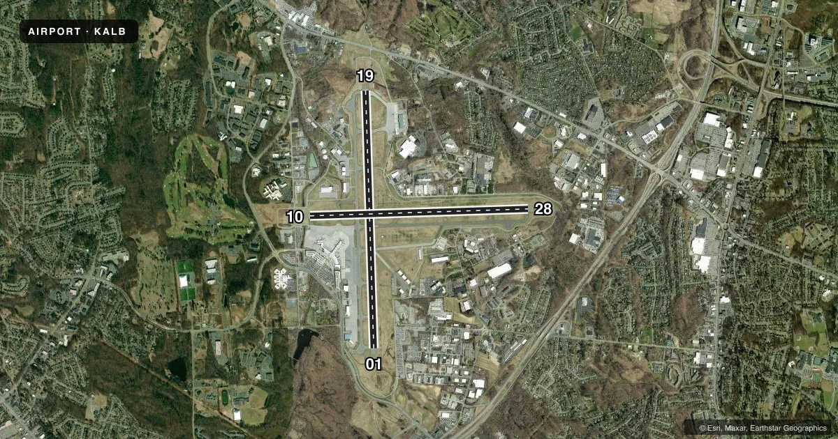
Runways & pattern
Full pagePattern entry · RWY 01
LEFT TRAFFIC| Runway | Heading (°M) | Length | Surface | Traffic |
|---|---|---|---|---|
| 01/19 | 345° / 165° | 8,500 ft | ASPH | Standard L |
| 10/28 | 75° / 255° | 7,200 ft | ASPH | Standard L |
Runway end performance
| End | TORA | TODA | ASDA | LDA | VGSI | Approach lights | Obstruction |
|---|---|---|---|---|---|---|---|
| 01 | 8,500' | 8,500' | 8,500' | 8,500' | PAPI 4-box right(3°) | MALSR | — |
| 19 | 8,500' | 8,500' | 8,500' | 8,500' | PAPI 4-box left(3°) | MALSR | 80', tree, 2040' from thr, 75' R of cntrln, slope 23 |
| 10 | 7,200' | 7,200' | 6,780' | 6,780' | — | — | 151', gnd, 5009' from thr, 84' R of cntrln, slope 31 |
| 28 | 7,200' | 7,200' | 7,200' | 6,007' | PAPI 4-box left(3.22°) | — | 54', tree, 1019' from thr, 162' R of cntrln, slope 15 |
Declared distances in feet. TORA = takeoff run available, TODA = takeoff distance, ASDA = accelerate-stop, LDA = landing distance.
Airport sketch
Runways drawn to scale from FAA survey coordinates, rendered over satellite imagery. Not for navigation.
Approaches & charts
ILS · 2
Services on the field
Fuel grades, oxygen, maintenance, ramp storage and lighting — as declared to the FAA by the airport operator.
Fuel & services
- Fuel
- 100LLA
- Oxygen (bottled)
- High pressure
- Airframe repair
- Major
- Power plant repair
- Major
- Other services
- CARGO,INSTR,RNTL,SALES,SURV
Ramp & ground
- Transient storage
- Tie-down
- Hangar
- Landing fee
- Yes
- Customs
- Available
- Lighting schedule
- SS-SR
- Beacon schedule
- SS-SR
- Beacon
- White / Green (civil land)(WG)
- Wind indicator
- Lighted
- Segmented circle
- No
Fuel & FBOs
Cheapest 100LL and Jet A on the field and nearby. Always confirm with the FBO before taxi.
Airport notes
Surface conditions, obstructions, local procedures, lighting outages and other notes published with each FAA cycle.
General notes
- TWY D EAST OF RWY 01/19 RSTRD TO ACFT 12500 LBS & LESS.
- BIRDS, DEER & OTHER WILDLIFE ON & INVOF ARPT.
- WX BALLOON LAUNCHES APRXLY 3 MI S OF ARPT AT 0600 & 1800.
- TWY C WEST OF TWY A: NON MOV AREA.
- CUST/IMG FLT INFO SVC FAC LCTD N END GA APN. ACFT CLRG CUST USE PAINTED PSN MKGS & PROCD TO MINIMIZE BLAST IMPACT.
- MOWING WI SAFETY AREAS OF ALL RWYS & TWYS MAY-NOV.
- NO ACFT PRKG BTN FIRE STN & TWY L.
Runway surface & condition
- 01/19PCR VALUE: 508/F/D/X/T
- 10/28PCR VALUE: 266/F/D/X/T
Approach & departure obstructions
- 10RWY 28 APCH RATIO 26:1 TO DTHR.
Other notes
- OWNERLEASEE. PROPERTY OWNED BY ALBANY CO, 112 STATE ST, ALBANY, NY 12207; FONE 518-447-7000.
VFR map & nearby airports
VFR sectional. Tap any ICAO chip to open that airport.
Key facts · KALB
Answer card- ICAO
- KALB
- Name
- ALBANY INTL
- Location
- ALBANY, NEW YORK
- Elevation
- 284.8 ft MSL
- Traffic pattern altitude
- 1,284.8 ft MSL (1,000 AGL)
- Control tower
- Towered · 24
- Total runways
- 2
- Longest runway
- 01/19 · 8,500 ft
- Published ILS approaches
- 2
- Published frequencies
- 19
- Magnetic variation
- 13°
- Current flight rules
- VFR
- Current wind
- 000° at 0 kt
- Favored runway now
- –
Albany Intl is in Albany, New York. The field elevation is 284.8 ft MSL. It has 2 asphalt runways. The longest is 8,500 ft on runway 01/19. Albany has a control tower that operates 24 hours. Two ILS approaches are published for runway ends 01 and 19.
The pattern altitude is not published in the facts provided. Check the current Chart Supplement before you go. Million Air is on the field. It carries 100LL, Jet A and Jet A Prist. Call (518) 242-2444 for current service details. The airport sits under Class C airspace. Albany Approach and Departure are on 118.05. D-ATIS is 120.45. Ground is 121.7. UNICOM is 122.95.
A few local items matter here. Wildlife is reported on and near the airport. Taxiway D east of runway 01/19 is limited to aircraft 12,500 lb and less. Runway 28 has a published displaced-threshold obstacle note. Customs and immigration processing is handled at the north end of the general aviation apron. If you are planning a first arrival, brief the tower early and watch for the airport’s mixed airline and GA traffic. The runway lengths are generous. The main things to verify are current pattern guidance, taxi routing and any operational notes in the Chart Supplement.