METAR & TAF 1H4
1H4 does not publish a METAR.
Showing the nearest reporting station: KALB (ALBANY INTL) · 21.8 NM away. Conditions at 1H4 may differ.
METAR · KALB
Observed 12:51Z
KALB 271251Z 00000KT 10SM FEW100 FEW180 FEW250 23/17 A2985 RMK AO2 SLP105 T02280167 $
- Wind
- 000° @ 0 kt
- Visibility
- 10 SM
- Temp / Dew
- 23°C / 17°C
- Altimeter
- 29.85 inHg
- Clouds
- FEW
- Density alt
- 2,088 ft
- Ceiling
- Unlimited
- Rules
- VFR
Airport info & contacts
Manager on record, flight service, ARTCC, attendance schedule and pattern altitude — published by the FAA and refreshed every 28 days.
Location
- From city
- 1 NM E
- VFR sectional
- NEW YORK
- ARTCC
- ZBW · BOSTON
- NOTAM facility
- BTV (NOTAM-D)
Airport manager
- Name
- WALTER J BIRMANN
- Phone
- 518-966-5343
- Address
- 3822 COUNTY ROUTE 26, GREENVILLE NY 12083
Flight service · Hours
- FSS BTV
- BURLINGTON1-800-WX-BRIEF
- Attendance
- MAY-NOV · DALGT
Frequencies
Tap any row to copy the frequency to your clipboard.
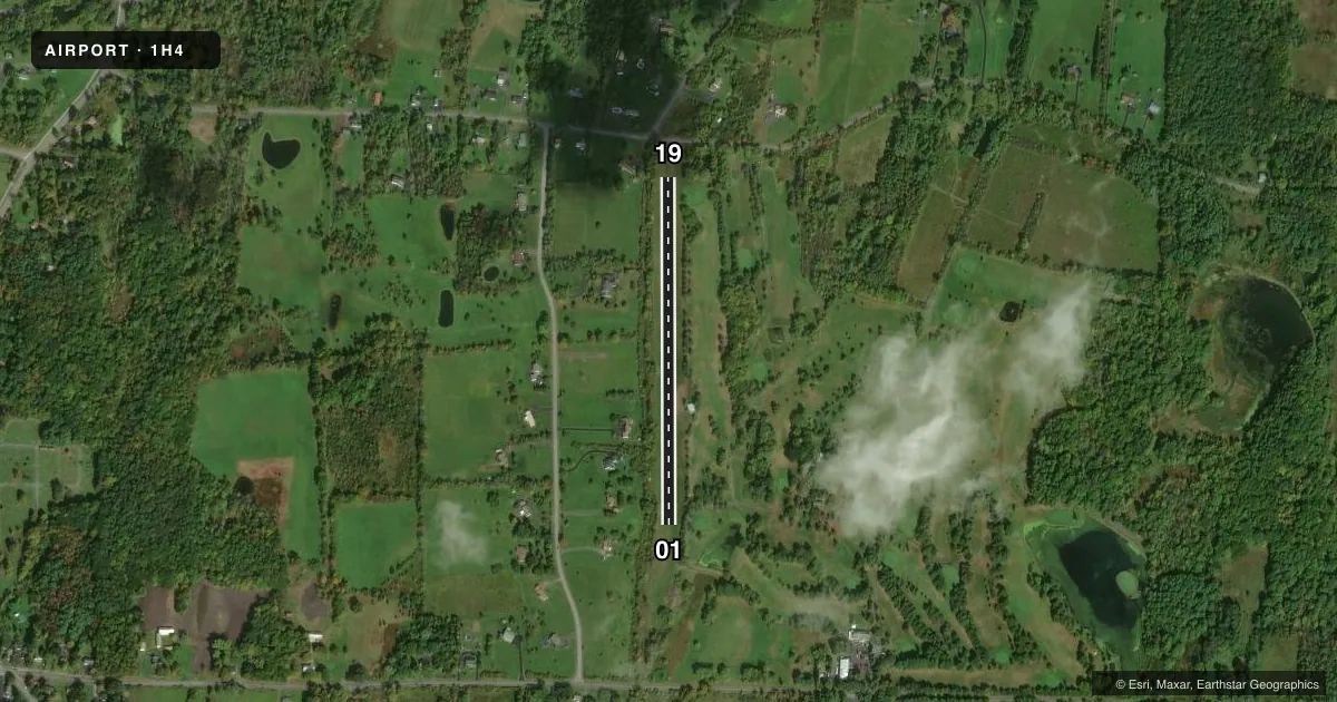
Runways & pattern
Full pagePattern entry · RWY 01
LEFT TRAFFICRunway end performance
| End | TORA | TODA | ASDA | LDA | VGSI | Approach lights | Obstruction |
|---|---|---|---|---|---|---|---|
| 01 | — | — | — | — | — | — | 50', trees, 17' from thr, 97' R of cntrln, slope 0 |
| 19 | — | — | — | — | — | — | 56', trees, 20' from thr, 56' R of cntrln, slope 1 |
Declared distances in feet. TORA = takeoff run available, TODA = takeoff distance, ASDA = accelerate-stop, LDA = landing distance.
Airport sketch
Runways drawn to scale from FAA survey coordinates, rendered over satellite imagery. Not for navigation.
Approaches & charts
Services on the field
Fuel grades, oxygen, maintenance, ramp storage and lighting — as declared to the FAA by the airport operator.
Fuel & services
- Fuel
- Not available
- Airframe repair
- Not available
- Power plant repair
- Not available
Ramp & ground
- Transient storage
- Tie-down
- Hangar
- Landing fee
- No fee published
- Wind indicator
- Yes
- Segmented circle
- No
Fuel & FBOs
Cheapest 100LL and Jet A on the field and nearby. Always confirm with the FBO before taxi.
Airport notes
Surface conditions, obstructions, local procedures, lighting outages and other notes published with each FAA cycle.
General notes
- RWY 01/19 MAY BE CLSD AFTER RAINS DUE TO WETNESS.
- RWY 01/19 SOFT & WET DURING MAR-JUN.
- APT CLSD DEC 1 THRU APR 1.
- +30 FT POWER LINE PARALLEL TO AND 150 FT WEST OF RY CNTRLN.
- FOR CD CTC ALBANY APCH AT 518-862-2299.
Approach & departure obstructions
- 01RY EDGES AND DSPLCD THLD MRKD BY WHITE MARKERS (1 FT SQ.); END OF USBL RY NOT MKD AND IS 112 FT NORTH OF WHITE THLD MARKERS.
- 19RY EDGES AND THLD MARKED BY WHITE MARKERS (1 FT SQ.)
- 010:0 CONTROLLING OBSTRUCTION SLOPE TO DSPLCD THLD DUE TO +53 FT TREES 81 FT RIGHT.
Other notes
- VFR ONLY.
VFR map & nearby airports
VFR sectional. Tap any ICAO chip to open that airport.
Key facts · 1H4
Answer card- ICAO
- 1H4
- Name
- GREENVILLE-RAINBOW
- Location
- GREENVILLE, NEW YORK
- Elevation
- 840 ft MSL
- Traffic pattern altitude
- 1,840 ft MSL (1,000 AGL)
- Control tower
- Non-towered (use CTAF)
- Total runways
- 1
- Longest runway
- 01/19 · 1,801 ft
- Published ILS approaches
- 0
- Published frequencies
- 2
- Magnetic variation
- 14°
- Current flight rules
- VFR
- Current wind
- 000° at 0 kt
- Favored runway now
- –
Greenville-Rainbow (1H4) sits in Greenville, New York at 840 ft MSL. It has one runway. Runway 01/19 is 1,801 ft of turf, so plan for a short-field, soft-field operation. The airport is not towered. CTAF and UNICOM are both 122.8. No ILS approaches are published here. The pattern altitude is not published, so use the standard 1,000 ft AGL unless the current FAA Chart Supplement says otherwise.
This field is VFR only. The airport is closed from December 1 through April 1. Runway 01/19 may also close after rain because the surface gets wet. The runway is soft and wet during March through June. There is a 30-foot power line parallel to the runway. It sits about 150 feet west of centerline. Runway 01 has a displaced threshold. The usable end is 112 feet north of the white threshold markers. Trees off the right side create a zero-to-zero controlling obstruction slope to that threshold.
For clearance delivery, contact Albany Approach at 518-862-2299. There are no on-field FBOs listed, so verify services before you go. If you are planning a first visit, treat this as a turf strip with seasonal and weather-related limits. Check the current FAA Chart Supplement before departure.