METAR & TAF 1B1
1B1 does not publish a METAR.
Showing the nearest reporting station: KPSF (PITTSFIELD MUNI) · 20.3 NM away. Conditions at 1B1 may differ.
METAR · KPSF
Observed 11:54Z
KPSF 271154Z AUTO 00000KT 10SM SCT060 17/14 A2986 RMK AO2 SLP088 T01720144 10172 20128 51004
- Wind
- 000° @ 0 kt
- Visibility
- 10 SM
- Temp / Dew
- 17°C / 14°C
- Altimeter
- 29.86 inHg
- Clouds
- SCT
- Density alt
- 560 ft
- Ceiling
- Unlimited
- Rules
- VFR
Airport info & contacts
Manager on record, flight service, ARTCC, attendance schedule and pattern altitude — published by the FAA and refreshed every 28 days.
Location
- From city
- 4 NM NE
- VFR sectional
- NEW YORK
- ARTCC
- ZBW · BOSTON
- NOTAM facility
- BTV (NOTAM-D)
Airport manager
- Name
- BRIAN MCDONALD
- Phone
- 518-828-0871
- Address
- 401 STATE STREET, 178 ROUTE 23B, HUDSON NY 12534
Flight service · Hours
- FSS BTV
- BURLINGTON1-800-WX-BRIEF
- Attendance
- 0700-1800
Frequencies
Tap any row to copy the frequency to your clipboard.
Runways & pattern
Full pagePattern entry · RWY 03
LEFT TRAFFICRunway end performance
| End | TORA | TODA | ASDA | LDA | VGSI | Approach lights | Obstruction |
|---|---|---|---|---|---|---|---|
| 03 | — | — | — | — | PAPI 4-box left(3°) | — | 62', tree, 1370' from thr, 342' R of cntrln, slope 18 |
| 21 | — | — | — | — | PAPI 4-box right(3.52°) | — | 30', tree, 430' from thr, 219' R of cntrln, slope 7 |
Declared distances in feet. TORA = takeoff run available, TODA = takeoff distance, ASDA = accelerate-stop, LDA = landing distance.
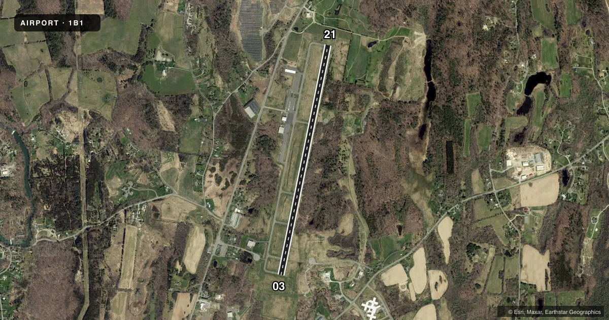
Airport sketch
Runways drawn to scale from FAA survey coordinates, rendered over satellite imagery. Not for navigation.
Approaches & charts
Services on the field
Fuel grades, oxygen, maintenance, ramp storage and lighting — as declared to the FAA by the airport operator.
Fuel & services
- Fuel
- 100100LLA1+
- Oxygen (bottled)
- High pressure
- Oxygen (bulk)
- High pressure
- Airframe repair
- Major
- Power plant repair
- Minor
- Other services
- CHTR,INSTR
Ramp & ground
- Transient storage
- Tie-down
- Hangar
- Landing fee
- No fee published
- Customs
- Not available
- Lighting schedule
- SEE RMK
- Beacon schedule
- SS-SR
- Beacon
- White / Green (civil land)(WG)
- Wind indicator
- Yes
- Segmented circle
- Yes
Fuel & FBOs
Cheapest 100LL and Jet A on the field and nearby. Always confirm with the FBO before taxi.
Airport notes
Surface conditions, obstructions, local procedures, lighting outages and other notes published with each FAA cycle.
General notes
- FOR CD CTC ALBANY APCH AT 518-862-2299.
- RWY 21 DSGND CALM WIND RWY.
- WILDLIFE ON AND INVOF ARPT.
- RWY COND NOT MNT OR RPTD WHEN ARPT UNATNDD.
- GRASS CUTTING EQPT OPS ADJ TO ALL OP SVC AREAS, DALGT HRS APR-OCT.
Lighting notes
- ACTVT REIL RWY 03 & 21; MIRL RWY 03/21 - CTAF.
Fuel notes
- 100LL100LL SELF-SVC AVBL 24 HRS.
- A1+FULL SVC JET A AVBL AFT HRS BY PRIOR ARRGMNT; CALL 518-828-9461.
Other notes
- A/C MAINT ASST AVBL AFT HRS; CALL 518-828-9461
VFR map & nearby airports
VFR sectional. Tap any ICAO chip to open that airport.
Key facts · 1B1
Answer card- ICAO
- 1B1
- Name
- COLUMBIA COUNTY
- Location
- HUDSON, NEW YORK
- Elevation
- 198.4 ft MSL
- Traffic pattern altitude
- 1,198.4 ft MSL (1,000 AGL)
- Control tower
- Non-towered (use CTAF)
- Total runways
- 1
- Longest runway
- 03/21 · 5,350 ft
- Published ILS approaches
- 0
- Published frequencies
- 4
- Magnetic variation
- 13°
- Current flight rules
- VFR
- Current wind
- 000° at 0 kt
- Favored runway now
- –
Columbia County Airport sits in Hudson, New York. Field elevation is 198.1 ft MSL. The airport has one runway, 03/21, which is 5,350 ft long. There is no control tower. Pattern altitude is not published, so use the standard 1,000 ft AGL for light piston operations unless the current Chart Supplement says otherwise.
No ILS approaches are published here. Approach and departure service is through Albany on 132.825 and 307.2. CTAF and UNICOM are both 123.05. For clearance delivery, Albany Approach is listed at 518-862-2299. Runway 21 is the calm wind runway. Runway end identifier lights are available for 03 and 21. Medium intensity runway lighting is available for 03/21 and is controlled by CTAF.
Richmor Aviation is on the field. It carries 100LL and Jet A. 100LL self-serve fuel is available 24 hours. Full service Jet A is available after hours by prior arrangement. After-hours maintenance assistance is also available by calling the same number. Watch for grass cutting equipment near operational areas from April through October. Wildlife is present on and near the airport. Runway condition is not maintained or reported when the airport is unattended.